• Happy First Use of Insulin to Treat Diabetes (1922)! ⚕️💉

Leaving tonight - SPOT tracking page

Jim, it does appear Alan stayed put yesterday, could be wind issues as he has a couple of lakes to cross on his way North up the Putahow, or, since he was hoping to be there for the Caribou migration and if he happened upon that event it would be a good reason to not move for a few days.

The day he backtracked he may have done a food cache since he has to come by that on the way from Nueltin.

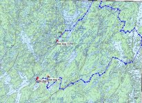
I'll put a map or two together for you so you get an understanding of his route. So far, he started on Wollaston Lake in Saskatchewan, crossed the lake and headed downstream on the Cochrane River to the height of land crossing. He then was heading downstream on the Thlewiaza River. At the point he made the jog back upstream, he did another set of portages to get into the Putahow River, which is where he is now. In the Putahow he can go downstream to Neultin Lake than will come back up the Thlewiaza. That would be the little loop at the top of the trip, then he retraces his steps back to Wollaston.

Simple right?
 
No Title

Does this help? There are 20 rapids indicated on the topo map from his present position out to Neultin Lake.
 

Attachments

  • photo5081.jpg
    photo5081.jpg
    229.6 KB · Views: 1
Yes ! By the Spot map, it looks like he's traveling on dry land.
With 20 portages, he is to some extent.


​Thanks again Karin !!!
 
Jim, because Alan is only doing daily check ins, the Spot just joins the dots, as the crow flies so to speak. With the mapping program I have I can also track his route for distances, yesterday he did a pretty good 26km/16 miles. In his thread on MyCCR he indicated he was hoping to do 20 miles a day, tomorrow will be 3 weeks into the trip.
 
A thought on Alan's previous back track. I recall the long set of rapids in Downes book, Alan was a little concerned about them but then later told me he read of someone else who had made the run down them who had thought they were great and the better part of the trip. If that run he made and backtracked was the set of rapids Downes spoke of, and he ran down them by turning right then maybe the reason he did so was because he simply wanted to run them, that if he did not turn right and instead simply went around the loop the way he is now he would only portage around them as he finished his loop.

One more thought, anyone know of a place to get wind/ weather reports from this area? His Mother, who is far more savvy then I with a computer has been stymied in her attempts.
 
One more thought, anyone know of a place to get wind/ weather reports from this area? His Mother, who is far more savvy then I with a computer has been stymied in her attempts.

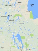
Umm, no, not really. Without any towns or much people at all up that way, nothing even close is reported. Churchill on the coast is the highest point with reports but due to being on the coast it likely isn't a good representation. Brochet (Lynn Lake) may be more accurate despite being much further south. I would pick something between the two but nights are likely in the 40's or lower given he is at the top of Manitoba and moving into Nunavut. That is seriously empty of humans up there.

http://weather.gc.ca/city/pages/mb-42_metric_e.html

http://weather.gc.ca/city/pages/mb-53_metric_e.html
 
A thought on Alan's previous back track. I recall the long set of rapids in Downes book, Alan was a little concerned about them but then later told me he read of someone else who had made the run down them who had thought they were great and the better part of the trip. If that run he made and backtracked was the set of rapids Downes spoke of, and he ran down them by turning right then maybe the reason he did so was because he simply wanted to run them, that if he did not turn right and instead simply went around the loop the way he is now he would only portage around them as he finished his loop.

Roy, that makes sense. My first thought was “food cache”, but if it were solely that it would have been easier to leave it at the confluence near where he camped.
 
No Title

Ok, for a matter of perspective. Alan is about 950km/590 miles north of where we live as the crow flies.
 

Attachments

  • photo5125.jpg
    photo5125.jpg
    81.9 KB · Views: 0
Epic I tell you, truly epic. How the hell do you top this? He will be ruined for lesser trips now.
 
Epic I tell you, truly epic. How the hell do you top this? He will be ruined for lesser trips now.

How true!!
I could see Alan writing a book, describing the design and build of his Bloodvein II, as well as his solo (except for Sadie) travels. Who knows, his self made videos could go viral and he could become temporarily famous!
Meanwhile, I'll be following along and anxiously awaiting his return and his trip reports...
 
He is still a looooooong ways out yet. Lots of great paddling and awesome times to be had.
 
I have been wondering what kind of fish live under his canoe? Did he ever mention to anyone on this forum, if he fishes to supplement his diet? I know I would, in a worst case of hunger, I would dig deep into my pack and pull out a little rag of mono gill net I got in Finland. I never had to use it, but it has given me comfort knowing i had it along. Any native brook (speckled) trout in the area he is in?
 
He is generally not an angler, it just slows him down. I cannot imagine being in area's that see so few humans and not fishing though.

Up that far it is mostly Lake Trout, Northern Pike and perhaps Grayling.
 
Last edited:
Back
Top