- Joined
- Aug 10, 2018
- Messages
- 1,204
- Reaction score
- 1,591
In my wrap-up from my BWCA trip, I'd stated that I'd share the inReach link next trip so people could follow along at home if they wished. I, of course, didn't do that last year when I did the Steel River loop but as Glenn suggested in this thread, I will do so on this year's trip. (Glenn: if there's a better place for this post, feel free to move it)
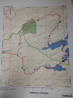
This Sunday morning, I'm headed for Memaquay's backyard again and I'll be taking a very leisurely trip on the Marshall Lakes loop. I'm told that it's typically done in 5-7 days but I'm planning on taking my time, doing a lot of fishing, exploring every campsite or other point of interest that I find and turning it into a 10-12 day trip (including the side trip into Faulbert where I might take a layover day, except that it's pretty early in the route). I'll post the 1st page of Mem's map set but I'll allow him to share the rest as he wishes.
As recped did for his Paddling in Circles thread, I've switched the mapshare feature on my inReach to "public" so that anyone interested can follow along without a password. I don't think you can message me but, if I'm wrong, I ask that you please don't. With the plan that I'm on, I get 40 free messages and I know, going in, that one each day will be used by my dad (which, at 87, I'll gladly allow) when he sends an "ok, thanks" response to the nightly "all clear". (I have no idea what additional messages cost but I'd rather not find out)
If you're wondering what friends & family see when you're in the woods and they're at home, you can check the mapshare and see what the inReach provides them. If you carry a Spot or Zoleo and care to share the tracking, I'm ok with you doing it on this thread or starting your own (I'm curious to compare the others)
Here's the link to mine: https://share.garmin.com/YOEM6 (in case you're curious, the "YOEM6" has no significance... Garmin assigned it & I let it be)
My protocol is to turn on the device in the morning, just before I break camp (sometimes takes a few minutes for the tracking to start), leave it on & tracking all day (it reports my whereabouts every 10 minutes) until I'm done traveling. I send an "all clear" to those at home before I hit the sack and it then gets turned off to save the battery and recharge.
One further request: I tend to drive rather quickly and would appreciate it if nobody calls the highway patrol and tips them off that "there is an old, multi-colored Ford Ranger with a canoe on the roof that's haulin' butt around mile marker _____". Thanks in advance.
This Sunday morning, I'm headed for Memaquay's backyard again and I'll be taking a very leisurely trip on the Marshall Lakes loop. I'm told that it's typically done in 5-7 days but I'm planning on taking my time, doing a lot of fishing, exploring every campsite or other point of interest that I find and turning it into a 10-12 day trip (including the side trip into Faulbert where I might take a layover day, except that it's pretty early in the route). I'll post the 1st page of Mem's map set but I'll allow him to share the rest as he wishes.

As recped did for his Paddling in Circles thread, I've switched the mapshare feature on my inReach to "public" so that anyone interested can follow along without a password. I don't think you can message me but, if I'm wrong, I ask that you please don't. With the plan that I'm on, I get 40 free messages and I know, going in, that one each day will be used by my dad (which, at 87, I'll gladly allow) when he sends an "ok, thanks" response to the nightly "all clear". (I have no idea what additional messages cost but I'd rather not find out)
If you're wondering what friends & family see when you're in the woods and they're at home, you can check the mapshare and see what the inReach provides them. If you carry a Spot or Zoleo and care to share the tracking, I'm ok with you doing it on this thread or starting your own (I'm curious to compare the others)
Here's the link to mine: https://share.garmin.com/YOEM6 (in case you're curious, the "YOEM6" has no significance... Garmin assigned it & I let it be)
My protocol is to turn on the device in the morning, just before I break camp (sometimes takes a few minutes for the tracking to start), leave it on & tracking all day (it reports my whereabouts every 10 minutes) until I'm done traveling. I send an "all clear" to those at home before I hit the sack and it then gets turned off to save the battery and recharge.
One further request: I tend to drive rather quickly and would appreciate it if nobody calls the highway patrol and tips them off that "there is an old, multi-colored Ford Ranger with a canoe on the roof that's haulin' butt around mile marker _____". Thanks in advance.

