- Joined
- Aug 21, 2018
- Messages
- 1,726
- Reaction score
- 1,914
In 2019, Kathleen and I paddled the Yukon River, from Whitehorse to Dawson City. The following is what I wrote in my journal at the end of that trip.
Kathleen and I had spent 17 days and 7,250 km (4,500 miles) on the road to live only 14 days on the Yukon River. Was it worth it, some might ask. What a silly question, though. I apologize for putting words in your mouth. Kathleen and I are northern river canoeists. Of course it was worth it. Besides, the road trip was an integral part of the adventure, and will certainly provide many lasting memories.
Kathleen and I are now deciding where to go next. As you might remember, we thought it might be nice to go on a guided trip, and let someone else, like Rainer Russmann, of Yukon Wild, with whom we shared a camp on the Yukon River, do all the work.
We looked at Rainer’s webpage, and saw that he offers trips on the Blackstone River, down to the Peel River, above the Aberdeen Canyon. The Blackstone River had always appealed to me, except for the part about having to portage as much as 10 km (six miles) around Aberdeen Canyon. Rainer’s trip though, flies home before the portage. Maybe we should book that trip, we thought.
Rainer lists the trip at $5,500 Canadian per person, for a total cost to me and Kathleen of $11,000 Canadian (about $8,250 U.S.) That’s a lot of money, for less than two weeks of actually being on the river. Of course, that includes float plane flights, some accommodation, all you can eat, and the sheer joy of watching Rainer doing all the work. But still, that’s a lot of money.
But we have to spend a lot of money, and time, no matter what trip we pursue. Our preference is to be in the far north, certainly north of sixty degrees, and preferably north of the Arctic Circle. When we reflect on our wilderness canoe trips, our favourite was the Thelon River, in 1993, when we paddled east for 37 days and 950 km (590 miles) from the outlet of Lynx Lake down to Baker Lake at the head of Chesterfield Inlet on Hudson Bay.
Several rivers are tied for our second favourite trip. But we much enjoyed our adventure in 2001, when we flew back to Lynx Lake, and then paddled west to Whitefish Lake, and then portaged over the height of land to Sandy Lake and the Snowdrift River, which carried us back toward Great Slave Lake.
These two northern trips both featured nearly constant daylight and the spectacular scenery and isolation of the Barren Grounds. This is what we seek. So our plan now is to fly to the western edge of Whitefish Lake, and then paddle back toward the eastern edge of Lynx Lake. We might not even make it that far. We might just find a few spots that we like, and set up base camps. We are getting older. We no longer feel the need to break camp every day just to cover more distance. How much will it cost? Kathleen says it doesn’t make any difference. It’s what we want to do.
For your enjoyment—or at least for our enjoyment—I have provided four images of our Thelon and Snowdrift River trips. We hope to return next summer (2020)
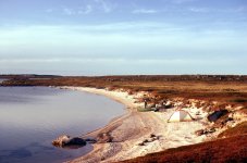
Outlet of Lynx Lake, to the Thelon River, 1993
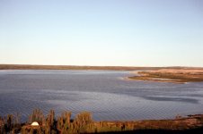
Thelon River below confluence with the Elk River, 1993
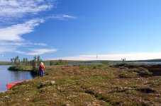
Looking toward Whitefish Lake, 2001
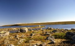
Whitefish Lake camp, 2001
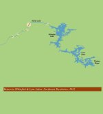
So, in January of 2020, I put down a non-refundable deposit with Ahmic Air in Yellowknife to fly Kathleen and me to the northwest corner of Whitefish Lake—please see diagram on title page. Unfortunately for us, and the world at large, the COVID-19 pandemic broke out soon after, and the Northwest Territories closed its borders, which remained closed, even for the following year in 2021.
Finally, though, in 2022, the Northwest Territories re-opened its borders to tourists, so I contacted Stephen, at Ahmic Air to resurrect our reservation. I also emailed him our 14-day proposed itinerary.
Kathleen and I are getting older. I’m 74, and she is 70. Our legs are starting to go, and the canoe felt a lot heavier, when I got it out of the shed. We planned this to be a leisurely, slow-paced, northern canoe trip, as it will likely be our last time out onto the Barren Grounds. Only 138 km (86 miles) over 14 days. Just an average of 10 km (six miles) per day. Easy peasy. As an added bit of comfort, we also pre-booked two nights at the Lynx Tundra Lodge, a smidge over half way through the trip. It would be an enjoyable break. Have a shower. Sleep on a bed. Maybe someone would even offer to make coffee for us. Maybe the coffee would be available on a non-stop basis. We had never seen the lodge on our previous trip up Lynx Lake, so I entered its coordinates into my GPS:
Lynx Tundra Lodge 620 27.35’ N, 1060 degrees 18.014’ W.
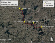
Just for fun, I created this Google Earth map for five of our intended destinations. We planned to begin this trip close to the former camp of the late ‘Tundra’ Tom Faess. We had visited Tom’s camp on our 2001 trip to the Snowdrift River, and tremendously enjoyed his generosity of a free shower and cups of coffee. We were curious what, if anything remained of his camp since his passing away from cancer on April 1, 2018.
After being dropped off by the float plane, and briefly reminiscing about the over-the height-of-land portion of our journey to the Snowdrift River in 2001, we then intended to paddle to Gordon’s Esker. In 2001, Kathleen and I had been windbound for two days on a small beach directly opposite a scenic esker. When we finally reached Tom’s camp after the wind died, I asked the assembled guests, “So, two days ago, Kathleen and I had been camped across from an esker about six km (four miles) from here. We saw a boat with a motor leave the esker and head west. Was it your boat?”
“Yes it was,” replied a lady. “We were visiting Gordon’s esker. Lots of artifacts there.”
“I didn’t know that. Why is it called Gordon’s esker?”
“It was named for Bryan Gordon,” Tom said. “Gordon did a lot of archeological work there. About 10,000 Dene artifacts have been found on that esker.”
Tom further explained that the Whitefish Lake corridor was important for hunting, as the caribou always crossed Whitefish Lake at Gordon's Esker because the water is only 4 ft. (1.3 m) deep.
“The caribou were easy to hunt in the shallow water.”
“Interesting. Too bad Kathleen and I didn’t know that. Would have been great to camp on that esker.”
Well, Kathleen and I had another chance to camp on Gordon’s Esker. We’d be there on July fifth.
On July 10, as you can see from our itinerary, we intended to camp at Lynx Creek Esker, the same spot where we had accidentally camped in 2001. I think I hear you asking, “Accidentally? How can you camp at a spot accidentally? Didn’t you camp there on purpose?”
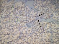
Lynx Lake 1:250,000 Topographic Map
Well, yes and no. Let me explain. Until this current trip, I always navigated with compass and map. Although our kids gave us a GPS for Christmas in 2000, I didn’t take it on our 2001 canoe trip. I prefer map and compass. A map always works. A compass always works. Neither needs batteries nor clear, unobstructed sky. Unless I am paddling through a of complex landscape, I use 1:250,000 topographic maps, like the one pictured above. The lower arrow, near
the end of Lynx Lake, points to a small gap that leads to LaRoque Bay, and eventually Whitefish Lake. The upper arrow points to a narrow channel between LaRoque Bay and Lynx Lake.
When Kathleen and I approached the small gap in 2001, we paddled right on by, against the south shore, and didn’t notice or recognize the small gap. About ten minutes later, however, we certainly noticed the prominent esker on the north shore, which was west of the small gap that we were looking for. “I think maybe we’ve gone to far, Kathleen.”
“Let’s just go a bit more, just to make sure.”
“Sounds good.”
So that’s what we did. We paddled a bit more, and accidentally stumbled across one the best camping sites we’ve ever enjoyed on a wilderness canoe trip. A wide, long sandy beach. Great camping spots above the beach. And, compared to most of our Barren Grounds trips, a reasonable amount of firewood. “Let’s camp here Michael. We can hike back tomorrow to confirm that the small gap to LaRoque Bay and Whitefish Lake is actually where we think it is.”
The next morning, we confirmed that we had paddled right on by the narrow gap. But our great campsite took us only a little bit out of our way. We intend to camp at the Lynx Creek Esker again on this trip. In fact, we’ve even scheduled a rest day there. Looking forward to revisiting one of the best camping sites we’ve ever enjoyed on a wilderness canoe trip.
The final yellow pin indicated on the Google Earth map is where Ahmic Air will pick us up, at the outlet to the Thelon River. I entered the coordinates given to us by Stephen into my GPS:
Outlet to Thelon River 62°21’ N, 1060 00’ W. This is the same spot that Kathleen and I flew to in 1993 when we paddled all alone down the Thelon River to Baker Lake. It will be fun to reminisce on site.
To make sure that Ahmic Air knows where we are on the scheduled pickup day, we will be renting a satellite phone from CasCom/Northern Communication in Yellowknife. Things can always go wrong on isolated, northern canoe trips. We must have communication.
Whitefish & Lynx Lake Itinerary For Kathleen & Michael Pitt (2022)
Day Date Activity Daily km
Tuesday July 5 Fly to Whitefish/Paddle to Gordon’s Esker 8
Wednesday July 6 Exploring Gordon’s Esker 0
Thursday July 7 North Side of East-extending Promontory 20
Friday July 8 Resting on East-extending Promontory 0
Saturday July 9 North End of LaRoque Bay 20
Sunday July 10 Esker at Lynx Creek 20
Monday July 11 Exploring Esker at Lynx Creek 0
Tuesday July 12 Entrance to Channel in West Arm of Lynx Lake 20
Wednesday July 13 Lynx Tundra Lodge 15
Thursday July 14 Lynx Tundra Lodge 0
Friday July 15 Northwest Entrance to Island-studded Channel 15
Saturday July 16 Resting in Entrance to Island-studded Channel 0
Sunday July 17 Outlet to Thelon River 20
Monday July 18 Revisiting Outlet to Thelon River 0
Tuesday July 19 Insurance Against Being Windbound 0
or Fly to Yellowknife
Wednesday July 20 Visiting Yellowknife
Last edited:

