• Happy National Pfeffernusse Day! ⚪🇩🇪😋

West Branch Penobscot from Roll Dam to Chesuncook Dam

You can always put in at Burbank Campsite ( a short way downstream from Roll Dam)
the only other low water issue would be by Big Island
We are doing the trip Aug 10-15. But we will start at Lobster trip and go to Lobster Lake for a couple of days then down river and down lake to Rip Dam.
I can try to remember to ask the folks at Caribou Gate or a ranger ( we usually run across one)
 
Much appreciated if you could ask! Also, the itinerary isn't set yet. Unsure if we want the extra river miles of staring at Roll Dam or would be better off starting at Lobster Stream with extra time at Lobster Lake.
 
When we launched at Burbank because of high water jamming debris under the Lobster put in bridge( you have to go under the bridge to get on the river. We looked for an alternate put in on the river side of the bridge - a no go) we started just below Roll Dam put in cause the river was running furiously. There had been a massive dam release up stream at Sebomook. Burbank had a set of stairs.. I think about a dozen. We launched off the top one.
The first few miles of the river were nice but kind of all the same. We had thought about putting in at Penobscot Farm but that was well underwater with no safe place for the truck without it possibly getting washed away
The extra miles you are mulling over. Its 8, Two hours paddling maybe more if you have to drag.

http://www.penobscotriver.net/penobscot-river.htm
Everyone has different objectives in their trip. We want to hang out at Big Claw as there often are moose there. And we want to paddle up Black Pond to the road at Caucomgomoc Lake and probably to Umbazooksus. before heading down Chesuncook and also visiting the Village.
 
Chesuncook is down 18 feet
From Roll Dam down might be bony but we met a duo that made it
from Lobster down low water many new but passable rips
campsites way up. Could not find Pine Stream
Allagash is closed from what I hear from
the Caribou Gate but I
 
Chesuncook is down 18 feet
From Roll Dam down might be bony but we met a duo that made it
from Lobster down low water many new but passable rips
campsites way up. Could not find Pine Stream
Allagash is closed from what I hear from
the Caribou Gate but I

Looks truncated. PM sent. I gather the campsites are kind of high and dry.
 
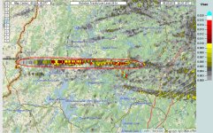
Nothing yet from Allagash Gateway Campground. It is in the path on the map and does have contact with the outside.. also the Caribou Checkpoint is in there.
 
I got in touch with Allagash Gateway Campground and they report "a quick downpour and that was that."

That stuff, tornados, derechos and downbursts can be very localized.

We paddled out of the Adirondacks midday in July 14, 1995. A Derecho hit the area that afternoon. Driving home with two boats atop the van I pulled off the road to park in the shelter of a brick bank building and still thought the van might topple over in the wind. The wife and kids were freaking out as the van rocked side to side.

https://www.spc.noaa.gov/misc/AbtDerechos/casepages/jul1995derechopage.htm

We camped at a site on Stillwater the next summer and it looked like a bomb had gone off dead center in the site, with every tree splayed out and splinterd on the ground in a * pattern from a microburst.

We had something, mini-tornado or derecho downburst, cut across a neighbors pasture some years ago. It snapped and splintered mature hardwoods 20 feet up the trunk, and fortunately missed the house. But not by much; the path of destruction through our woods was obvious.

While I tend to enjoy extreme weather conditions I never want to be camped in the path of that crap.
 
Back
Top