I'm looking at a small map with limited detail but the north finger goes from Carroll to Walking stick lake and the fire is listed at 86785 ha as of May 26 1500hrs
-
Happy National French Bread Day! 🇫🇷 🥖😋
You are using an out of date browser. It may not display this or other websites correctly.
You should upgrade or use an alternative browser.
You should upgrade or use an alternative browser.
Fire in WCPP
- Thread starter red langford
- Start date
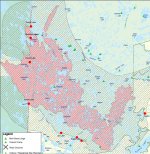
I just received the following update from Claire Quewezence (Assistant Park Superintendent);
Here's a screenshot of the .pdf that she sent me showing the updated fire map:

Just to keep you posted…. Red 3 is still with us even with this most recent weather . Despite yesterday’s rain, the fire area was still sending up smoke in various places, an indication that the fire has gone underground. The eastern flank of the flare-up that occurred last weekend is still active.
As a result, fire managers are not comfortable opening up the Iriam Road to the public just yet. It will remain closed till at least early next week. This also applies to the access points to Woodland Caribou as identified on the attached fire map.
Suppression efforts are ongoing to secure the eastern and northern boundary in that area.
Here's a screenshot of the .pdf that she sent me showing the updated fire map:
Attachments
Wow, that shows the heart of the park being burnt out. Close to half of the total area and not finished yet. I am glad we got in there a few years ago but what a shame. Craziness.
Yeah. I've accessed WCPP from every Manitoba access point and many times through Leano, so I'm glad for those memories, but I am very sad that for the foreseeable future the south part of the park and a large central portion will be problematic for traveling through. I guess I'll just have to find another wilderness area to explore! Like the Churchill River in Saskatchewan...
This will keep Marten busy the next decade or so and might open up areas he has wanted to find old portages to.
We are on our 4th straight day of rain here which can only help with more days forecast.
We are on our 4th straight day of rain here which can only help with more days forecast.
I spoke with Doug Gilmore this afternoon and he said the area that's burned is not quite a barren wasteland of char and indicated there was still lots of green in there. I did propose the park pay me to paddle and document all the good areas but the laughter told me my current job was not going to change.
Update on the fire. Good news! It has been raining for 2 days and that will be hammering the fire. Also according to senior fire crew the fire wasn't all devastating as the maps shows. It is not a 80000 ha swath of charred earth. There is still lots of green and lots will recover sooner rather than later. WCPP has a huge fuel load and what has likely happened is those areas that needed to burn did and those that didn't need to burn didn't.
Update on the fire. Good news! It has been raining for 2 days and that will be hammering the fire. Also according to senior fire crew the fire wasn't all devastating as the maps shows. It is not a 80000 ha swath of charred earth. There is still lots of green and lots will recover sooner rather than later. WCPP has a huge fuel load and what has likely happened is those areas that needed to burn did and those that didn't need to burn didn't.
That is great news. Thanks for sharing.
More good news. I received an email from Harlan in Red Lake also confirming that the fire left swaths of unburned areas within the fire boundaries. It sounds like there might be a lot less devastation than the maps would have us believe.
Great news, Thanks for posting those updates.
My favorite area of WCPP lies between the Gammon and Bloodvein Rivers and is still intact. I hear a finger did get up by Walking Stick but it was narrow. That leaves more country to paddle than you will cover in the coming years. This year the fires did force us to paddle in Quetico the last few weeks but plans are being firmed up for a return to the Pickerel infested waters of Walking Stick in July or August.
The last time I had a group in there one of the die-hard fishermen came back to camp first. He said when he stopped getting a Pickerel on every cast he quit fishing. Irvine is another lake with fishing like that. If you troll you will never getwhere you want to get to.Hold on here.....Pickerel infested waters?????!!!!! Time to dust off the map. You are singing my tune
The last time I had a group in there one of the die-hard fishermen came back to camp first. He said when he stopped getting a Pickerel on every cast he quit fishing. Irvine is another lake with fishing like that. If you troll you will never getwhere you want to get to.
Heaven. Pure Heaven.
") Have you heard about any of the routes out of Leano, whether they've been looked at or not?
Have you heard about any of the routes out of Leano, whether they've been looked at or not?The fire seems to not have moved much on the fire maps in a while. Rain, snow and such have really helped bring it under control. It looked to me like Leano Routes will be fine to Paull and Mexican Hat to Haven. Southwest of that area is in the burn area but I have heard that there is a lot of green and slightly tinged areas inside the fire perimeter as shown on the maps.
I have heard that there is a lot of green and slightly tinged areas inside the fire perimeter as shown on the maps.
Last year when I was around WCPP I came across areas that had burned that spring that looked like they'd been smaller ground fires that didn't get up into the trees. The portage trail I was on actually seemed to be the fire break as one side was burned and the other perfectly fine. Many of the trees still had needles on them but they appeared to now be dead (brown needles). I can imagine that right after the fire things still looked relatively green but that didn't seem to last for long. I don't know how this sort of thing normally works but hopefully it's not the same situation.
Alan
Fire is all but out. They are demobilizing the incident team and gathering up all the gear out in the bush. Leano Access road was graded but is in pretty rough shape. I used to be 90 minutes to get there but now budget 2 hours. Maybe slightly less but not much. Rain 4 out of 5 days did the trick.
There are still crews out there and helicopter traffic as well as trucks back and forth to Bunny Lake area by Leano so be aware and be safe.
PS. Black flies are thick in some areas at the moment and mosquitoes are starting
There are still crews out there and helicopter traffic as well as trucks back and forth to Bunny Lake area by Leano so be aware and be safe.
PS. Black flies are thick in some areas at the moment and mosquitoes are starting
Confirmed today with the Infrared crew, ZERO hot spots. Fire is out. Today there was some 50 crews that came off the fire. WCPP is back in business, but do confirm with the park office for the most accurate information.
That is odd Red since the Manitoba Fire site shows that fire as "Being Held". I guess in Ontario that is classed as being Out. Ha Ha.
I assure you this is is very up to date information. Seems the inter webs may be delayed information, or the fire install burning across the border.
Similar threads
- Replies
- 10
- Views
- 941
- Replies
- 10
- Views
- 2K