- Joined
- Aug 10, 2018
- Messages
- 1,332
- Reaction score
- 1,749
I'm starting to plan for 2025 and thinking of a mid August / early September trip in the Wabakimi area. (hopefully this past July's bugs are dead by then)
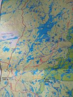
At this point, I'm considering parking in Armstrong and taking the train to Chivelston Lake (just East of the Savant Lake stop). From there, go North through Harris and Harold lakes to Savant lake and follow the Savant River to the Palisade River which can get me to Whitewater Lake. I'll check out whatever is left of the Wendell Beckwith cabins then head to Whiteclay lake, go up the Raymond River, check the pictographs on Cliff Lake and exit via Moonshine, Big Lake and Little Caribou.
My understanding is that this loop should reduce cost by starting & finishing on crown land instead of the being inside the Provincial park the whole time, it will pass through some rarely visited areas with incredible scenery, pictographs in at least 2 locations and some good fishing. The trade-off for this is that some of the lakes are huge and the portages might be rough or non-existent.
One thing I really like is that, if the portages turn out to be total bush-whacking, I'll have lots of options to shorten the route when I get to Whitewater (I have 2 weeks vacation from work but I'm figuring on taking an additional week without pay so I'll have 3 weeks at my disposal)
I've contacted Friends of Wabakimi (@jdeerfoot has been especially helpful), Ramblin' Boy, the Saugeen First Nation and Mattice Lake Outfitters for information on the state of the portages between the rail line and Savant (almost certain to be the least traveled section of the proposed route) but, so far, I've not been able to get any information and Google searches have yielded nothing.
(I've been hesitant to contact Bruce Hyer. Although I suspect he may have the best maps and information, he's also pricey and I don't want to waste his time unless I'm willing to cough up the $500 that seems to be his starting point)
Both Paddleplanner & the FOW planning map show portages existing but that's certainly no guarantee... Does anybody here have insight or an idea of where else to look for info?
Unless someone talks me out of it, I'll probably have the train dump me off & see what I find but I'd like to know that there's a reasonable chance of getting through. (and, yes, I'll post the inReach link here so you can follow along / speculate on difficulty / be glad you're not me... heck, maybe we can have a fundraiser with a "how far does he get / does he bail out via Smoothrock or press the SOS button" pool...)

