• Happy Mathematics Day! ❌📐♾️

Wallace to Sasaginnigak via the Bloodvein

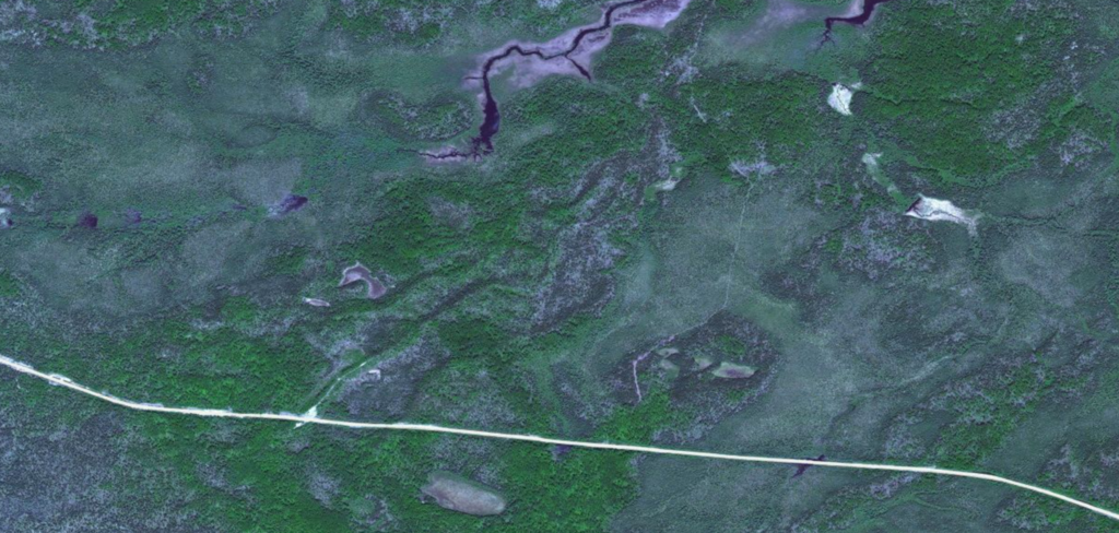
My 2 cents on this... the sat photo is pretty decent and shows the north end and a section in the middle that could be bog. The creek actually doesn't run the full length but swings east according to the topo. We were thinking if you stuck to the rock on the west side you could maybe keep your feet dry. The map from the Canadian Gov't site shows it being a straigh tline down the right side, but I imagine someone likely just made that up.

Official Canadian entry on it... http://www4.rncan.gc.ca/search-place-names/unique/GAXZW
Further info with lakes, rapids and falls... http://travelingluck.com/North+Ameri...m+Portage.html


Last edited:
The first third of that trek looks like it is through some wet ground. I wouldn't call that a portage. At least not one I would have very much fun at. But at least dragging 350M through a bog in late June there won't be any mosquitoes. /sarcasm

I hear there is some guy named Martin who likes to bushwhack his way through WCPP. He once wrote something about understanding the sat images as to what to expect on the ground in terms of vegetation. This same Martin is world famous as I spent the evening last night with a fellow paddler visiting all the way from Germany who had just finished 2 weeks in WCPP not following any routes and he cited this same Martin as a source for information and possibly inspiration. That sort of travel is much more adventurous than I had ever imagined. So saying all that I would not want to dispute a proven authority on reading satellite images, but isn't it possible that that line is just a deep ravine after looking at the topo?
 
I thought it was a ravine too, but Marten's Bing sat-photos suggest a shadow cast from the treeline. Seeing signs of a trail are hopeful.
 
I don't place much faith in sat images for finding ports. There are many places where I know there are portages, because I have cut them, and yet when I zoom in, even with high res, they are not apparent. Last week, I was trying to find the road into Marshall lake on Google Earth. This is a clear road through the bush...no go. Anything looking like a trail is probably a geological or vegetative feature. The one thing to keep in mind, is that almost all ports followed game trails at one time. If a ridge or some form of high ground is available, the port will follow it. If the high ground is not easily attained, you will be walking through swamp. Sat images are good for finding roads that have been completely cleared, like major bush roads, or logging roads where no trees exist, but anything with tree cover will usually not show up.

Edited to say, it is a mistake to place your faith in a sat image that a port exists. Ask me how I know. Hope can be a powerful motivator, but is quickly squashed upon reaching the designated area, and finding....welll......nothing except rocks and trees.
 
Last edited:
Don't want to derail the thread, but just thought I would provide an example of the confusion that a sat image can create. The image below shows the Ogoki road between Marshall lake and Meta Lake. The Ogoki road is the very visible one. You will also notice a gravel pit with a bit of a road running out of it and then another trail to the east of the gravel pit. One might think that either one of these trails would be the 2.2 kilometer port into Meta Lake, but one would be wrong. The gravel pit trail is sometimes a skidoo trail through a swamp, full of blowdown, hasn't been cleared since 2001. The road to the east is a mining road pushed through three years ago, and completely unfriendly to walking. The port actually follows the high ground directly east and adjacent to the sand pit. It then loops northwest to that small arm coming off the river, in the low ground. Try as one might, the actual port will not be visible from bing or google. However, one could find themselves on a wild goose chase following features that look like trails. I find local intel is usually the best way to find those out of the way ports. Make sure your sources are credible though, because there are many people who will repeat second hand info who have never actually been on the port.
 
Memaquay is making an important observation. Just try to find some known portages on a satellite image. I agree that most of what we see on this area's images are a ravine. What intrigues me is the smaller shadow or line that comes out of heavier tree cover about 400 meters from the south end of the hoped for portage. It then disappears into heavy trees again but seems to reappear as that shadow or line 150 meters left of the ravine at about 800 meters. It appears to be going through a low area and there is no change in foliage color on either side of the line. I am seeing no hint of a trail in the bog at the north end and this type of terrain often times will show signs of a trail for decades. That just adds to my suspicion that the best trail probably stays on the higher ground and avoids all the low ground on the north end. It may all be false hope but if I was going to investigate the area on foot I would print these maps images and also plot GPS info for the questionable lines or shadows. It is a nice bonus when you push through the heavy stuff following a GPS and find a decent trail.

I do enjoy doing this virtual exploring on the computer and it has made for some interesting journeys once I get to canoe country. One problem is that most of the trails you can spot on a satellite image are winter trails through wet stunted growth bogs.
 
Last edited:
I agree portage spotting from satellite photos can be pretty hit and miss.

Here are a couple more quotes from the old Berard map describing this trail:

"“North end trail follows bottom of cliff along west side of floating bog”."

At the Bloodvein end: "“Trail begins in marsh at narrow end of arm.”"

The Boy scouts of America still have a canoe tripping presence in the area, flying in now from Bissett. See here:

http://www.ntier.org/About/Summer Canoe Trips.aspx

Perhaps they might have some information on the current state of the portage?

Another option to reach Sassaginnigak from a little further south on the Bloodvein is shown on the Atikaki map here -– you have to zoom in considerably to see the canoe route markings.

https://www.gov.mb.ca/conservation/p...i_park_map.pdf

This route loops east via Scout and Noname lakes to reach Sassaginnigak. I wonder if "Scout Lake" has anything to do with the BSA?

I see the portage in question is not shown on the Atikaki map.

-wjmc

-jmc Capture.JPG
 
Last edited:
Thanks for all of your input. Marten, that Bing topi image is amazing.
WJMC, I have seen those scout badges in the cafe in Bissett, and some of the canoeists on fishing trips, but had never pursued the source. Good for them!
Red, the weather is calling foe wind at my back;)
Mem, you are right as usual, but the tops suggest .....
Karin and Christie, I hope to have a video of the fun portage.

I am off tomorrow morning, a day early. And will report my findings in about 17 or 18 days.

As of today I weigh 173 lbs. I bet I am 162 when I get back. Bets? Maybe start a pool.
 
Be sure to take the new dry edition of the portage north out of Craven. It is shown on the new WCPP map. Those portages were cleared in 2013 so should be in good shape.
 
Be sure to take the new dry edition of the portage north out of Craven. It is shown on the new WCPP map. Those portages were cleared in 2013 so should be in good shape.

The Craven to Ford portage is excellent, but the Ford to Artery portage is terrible. If that is an improvement, I would really, really, hate the old portage. With the new, improved Artery portage first 350 meters is so bad that I thought it was the old portage. I paddled up to the portage marker and started walking in a small creek in a bog surrounded closely by scrub pines and alder, with a poor path through wet, ugly dark staining peat and mud up to the knees most steps.What surprised me is that there was a decent place to walk only a stone's throw away, but the trail is through a mosquito bog. After 200 meters of that depressing trail, I thought that I must be on the old snowmobile track, and went back to the lake and searched for 2 hours for the real portage, only to find that there is not 3 trails or portages, but one! So off I went into the bog for a second try. It turned out that it is about 350 meters of slop in a tangle before a series of steep climbs and descents, that bottom mostly in wet bog.

But the trail was passable and I did survive the ordeal, but never again will pass that way. I can't believe that there was ever a real effort to make that a decent portage, and as far as "take the west trail" goes, there is only one trail, so no one should be saying anything about 2 or 3 trails, tracks, snowmobile tracks or even animal trails. (no animal is stupid enough to subject themselves to that trail). I would have found it most helpful if I was given the heads up from the park office when I asked them specifically about those 2 portages that the Ford to Artery portage was crap. If I sound upset, it is because I am. A little honesty would go a long way.

The Sakaoneekum portage is another story that I will get to tomorrow.

The 17 day solo was indeed epic and I had great weather, but I just got home yesterday and need some time to get the details out on the forum.
 
Be sure to take the new dry edition of the portage north out of Craven. It is shown on the new WCPP map. Those portages were cleared in 2013 so should be in good shape.
Sorry for any misunderstanding. My warning only concerned the portage from Craven to Ford as the Craven end was rerouted a few years ago. Both portages had been cleared in 2013 but the Ford to Craven was the original trail. The worst part is that it is 2100 meters of either the bog or steep climbs and drops back to bog. You noted that you could see better ground for a portage a short ways away, that has always been frustrating to me too. What often times happened is when the park was set up the old snowmobile trails were used for portages and those winter trails were easier to cut through the wet bogs than in the thick trees on dry ground. Over the years many have been improved ( like the Craven to Ford) but the Ford to Artery is one that is still a problem for paddlers. I do not recall even seeing the winter trail mentioned on the old WCPP map when I went through 10 years ago. I noted that the new WCPP map does not even show it. If I ever end up in that corner of the park I want to spend some time scouting for a fix for the Artery-Ford portage. I enjoy doing this and recording a GPS track of what I have found to be a better route. The park needs to do some assessments before they send in a crew to cut a new path. The new park map is laced with new portage paths that replaced a lot of bog walks.
 
Sorry for any misunderstanding. My warning only concerned the portage from Craven to Ford as the Craven end was rerouted a few years ago. Both portages had been cleared in 2013 but the Ford to Craven was the original trail. The worst part is that it is 2100 meters of either the bog or steep climbs and drops back to bog. You noted that you could see better ground for a portage a short ways away, that has always been frustrating to me too. What often times happened is when the park was set up the old snowmobile trails were used for portages and those winter trails were easier to cut through the wet bogs than in the thick trees on dry ground. Over the years many have been improved ( like the Craven to Ford) but the Ford to Artery is one that is still a problem for paddlers. I do not recall even seeing the winter trail mentioned on the old WCPP map when I went through 10 years ago. I noted that the new WCPP map does not even show it. If I ever end up in that corner of the park I want to spend some time scouting for a fix for the Artery-Ford portage. I enjoy doing this and recording a GPS track of what I have found to be a better route. The park needs to do some assessments before they send in a crew to cut a new path. The new park map is laced with new portage paths that replaced a lot of bog walks.

I appreciate your input, Martin. I know that Howard Holtman had a terrible time with the snowmobile trail from Ford to Artery back in 1997. The confusion for me was the fact that the Craven to Ford portage is often talked about in the same sentence or context as the Ford to Artery portage, and they are completely different. If the Ford to Artery portage started just a bit west of the existing trail, it would be mostly dry. Also, the Ford to Artery portage is exactly where the current park map shows, but there is no trace of any old portage trail at the Ford end. I have the old map so I know what was there at one time.

Also of note is the remains of the old portage at the Ford end of the Craven to Ford portage. Someone recently flagged the old trail so that when you reach Ford and are walking back, it appears as if the old trail is the correct trail. I put some branches over the old trail after I was fooled and had to backtrack. Hopefully they last so some poor soul doesn't waste time on that old trail. That new portage is really nice.

In any case, I meant no disrespect toward you. The old trapper snowmobile trails are still there, as I found out on the Sakakoneekum portage. When I finished that portage I was quite confident that Sakakoneekum means "winter trail only". Ha, ha It is funny now that it is over.

I will tell the story of that portage because it is quite intriguing. But I have to look after the iPhone right now.

Thanks again, Martin, your input is appreciated very much. I didn't mean to be a discouragement. BTW, I have read and enjoyed all of your trip accounts on canoestory.com.
 
Thanks for the clarification of where the confusion came from. I have always wondered why the old map shows two paths running parallel and very close together for 2100 meters. As you would have seen, moving to the side on the northern parts would not have changed the steep climbs to a bog walk alternative. I hope you have time to E-mail the park and inform them of the trail being flagged improperly. Wintertime use??

I will be awaiting your info on the Sakakoneekum portage as I plan on getting up there in the next few years. I know the area gets some use but details are hard to come by. Howard Holtman, his story prompted me to drive a little further to Woodland Caribou.
 
Was that your Denali parked at Wallace Lake? It was there Friday, gone Tuesday.

No, I wish I had a Denali, lol. I was dropped off at 12:30, Thursday, June 11 and left for a 17 day solo trip instead of 16, as I was able to leave a day early. My wife didn't argue because she was probably tired of me obsessing on that canoe trip. I was flown out from Kawaseecheewonk, also known as Little Sass, on Saturday, June 27th at 11:30. It was an epic trip in every sense. It was a privilege to have the opportunity to be in that part of the world at that time. Oh, and thanks so much for that Biolite. It sucks to do fine cooking, but if you travel all day and it is getting dark, a handful of twigs and some pine nuts will get a hot meal going. It is light and the fuel is every where so I did not have to bring any with me. I used and appreciated it a lot.
 
Thanks for the clarification of where the confusion came from. I have always wondered why the old map shows two paths running parallel and very close together for 2100 meters. As you would have seen, moving to the side on the northern parts would not have changed the steep climbs to a bog walk alternative. I hope you have time to E-mail the park and inform them of the trail being flagged improperly. Wintertime use??

I will be awaiting your info on the Sakakoneekum portage as I plan on getting up there in the next few years. I know the area gets some use but details are hard to come by. Howard Holtman, his story prompted me to drive a little further to Woodland Caribou.

I finally have the time and inclination to address the Sakakoneekum portage. There is a story attached that I wanted to tell because it involves those who keep the portage open. I kept a journal on this trip (there was no one to talk to for many days at a stretch). So, the Sakakoneekum...

The story begins at Artery lake where I was camped on the island in the south part of the lake, the first decent place to stop after the portage. I woke at 4:30 as usual because it is light, and light wakes me up. My left knee was in a fair amount of pain after the inward hyperextension in the middle of the last portage. I kneeled down with the large pack on, moved to the side and put too much stress on the tendons of my inner knee. It buckled, I fell, and it moved back into place. No audible pops or visible bruising, just some swelling. Close call, but I was ok. After this incident I was really careful about where and how I put my feet.

I was going to take a day off, but the campsite had at tree across to and someone had camped there in the winter and left a fire ring with 10 tin cans in it. My subconscience told me to leave and there was a wind from the south west, so I assessed my physical condition and thought that I could easily ride the wind to the pictographs at the north west part of the lake. Reasonable. So that is what I did, and enjoyed a free ride during an awesome day to the most amazing pictographs that I had ever seen. The wind, however had picked up, moved to more westerly, and threatened to get harsh. So I headed west into the wind, to where the Bloodvein drains the lake. It was a push when the wind picked up, but I made it to the portage where a lodge is located. As I approached the lodge, an American came out to the dock and said, " hey stop in here and have some food! We have lots, and don't say no!" Ok then. I had no problem answering questions and talking and accepting their hospitality. They even carried my gear across the portage. Thanks guys! I was feeling really good after that and my intention of taking a day off travel and the sore knee was at the back of my mind.

It started to rain as I began to paddle the Bloodvein, but my spirits were high. After I had travelled about 2 hours west on the river, I got out at a short portage, did one trip of my double, and what appears around the bend coming up the river, but a canoe with 2 guys coming up the river against the current. As they started to unload, I said to them, when they realized that I was there, "hey guys, the current is going THAT way". They chuckled and introduced themselves. They were Fred Marks and Jay Timmerman. Now, I had no idea who Fred and Jay were, but they told me that they were headed to Albany, which I thought was in New York, but apparently that day on the Bloodvein Albany was at James Bay, and the destination was 1,000 miles from their put-in at Bloodvein village. I learned when I got home that there is an Albany river that empties into James Bay and also a Fort Albany near the coast. I suppose that is why Fred said to me "Well, that is where Albany is, at James bay," when I made New York comments. It was getting late and Fred told me that they had a 12 hour day the previous, but we talked for about 20 minutes. Apparently they had done a previous trip that they wrote a book about.

http://www.amazon.com/Far-Distant-E...d=1435880859&sr=1-1&keywords=far+distant+echo

And Fred was the outfitter that had worked in Bissett with the Boy Scouts of America, and Jay had worked for 10 years as a guide for the scouts from Bissett. Noe Jay mentioned to me that he was the one who had talked the scouts' management into flying the young scouts into the north country instead of making them do the Obukowin portages.

I will post this and carry on so the computer doesn't eat everything.
 
And I completely understood why he had done that after I had completed the Sakakoneekum portage. As part of the scouts program, they maintain portages. To do the Mothers and the Sakakoneekum portages, and work on them on the same trip would push anyone to the brink of "what am I doing?!, there is something terribly wrong with this picture". Hardened adult trippers are pushed to the brink on those portages, and if you put 2 of them in the same trip, and ask them to cut rip-rap etc. , in my humble opinion, you are asking for a despising of the outdoors instead of an embracing. I thought a lot about what Jay had said because of my background and experiences.

Jay told me that the scouts had been maintaining that portage for quite some time. (I did not think to ask him of the origin of the portage, which I need to know now that I am into it as deep as I am.) He said that he had not been there since 2012 or 2013 but that I should expect to see a followable trail, some trail ribbons, and some rip-rap, that it was not easy, I would need a saw likely, but it was definitely there and doable. Well, that was great news to me!

The scouts are active and maintain the portages in that area, just as WJMC had said. I paddled until about 9:30 that night, stopped on a tiny island with gently sloping rocks at Stonehouse, and noted that I had done quite a bit on my day off.... A hot Biolite supper and to bed on the coldest night of the trip.

The next day I had a strong west wind again, fought it all day, and camped in the bay that leads to the Sakaoneekum portage. No one goes into that bay except the scouts, who have a camp at the mouth, so I camped in the bay where no person had set foot. I had a spectacular camp in a unique part of the Bloodvein. The next day was the big portage day, but there was fishing to check out on the way. Such fishing! The pickerel (walleye, lol) were thick and hungry and the pike were huge.

I approached the end of the bay and git out to scout it out. I went to the east and heard a strange animal noise and as I got closer to the noise, it sounded more threatening. I looked for the source of the sound, but could not find it. Then I heard a distinct MEEOOW sound. Weel, I had to admit that I had a lot to learn about the creatures that inhabit this territory, because I did not know what that was. Sure, I could guess, but I had no confidence that I was correct.

Back to the west of the bay I went, and there it was, the marker and a trail! The trail was just as Jay had described it, except he had omitted the waist deep bog and the thick bugs. This portage is passable, but it goes into every kind of terrain that exists from majestic mature forest to scrub pine in soggy bog, a shallow creek with bog here and there, and water so freezing cold in one place that if I didn't get out of it I would have had to stop because my feet were numb. It was so easy to see what had happened to the rip-rap program of the scouts. They started off well, with high spirits for maybe 500m and then gave up and just got through before the day and their strength was gone. It took me 4 1/2 hours of constant hard effort to get through. The best is saved for last, too. Just when you can see the lake and think you are done, there dis 150m of floating bog to struggle through. I put my packs in the canoe and dragged it as best as I could before I sank over my waist. When I was done that portage, I was stained with bog from head to toe, and there was mud and bog on everything. But I made it and I survived. I did feel for those poor scout kids who kept that portage open. That portage could be recut on mature forest mostly higher ground, but that would take 2 days for a 3 person crew to accomplish IMHO.

So that is it. I have some pics, but have to convert them to acceptable format which will take some time. I don't know how Karin gets her pics and reports done so fast and so well.

I hope this helps, Martin. Of course I have much more information about the area and the portage, which I will gladly share. This was the best canoe trip that I have ever done, and will be back to explore more and farther in the future.
 
I shoot most of my pics now on my Nikon, download them then edit in Lightroom 5. Most only need minor tweaking and I don't know the entire program, just what I need to use. I shot 63 photo's in 5 days, took a couple hours to edit down to 23 acceptable shots. I keep a journal daily but only use that for reference when writing the TR. I get it done as soon as possible after a trip so everything is fresh in my mind, especially the last day which doesn't get written down. I write it in Word first, then transfer to the site, less chance of loss that way.

It helps I enjoy writing them.
 
Back
Top