Curse of the Whip-poor-will
Rice River, Sept 1-5, 2014
Day 1
The forecast wasn't the best for the first week of September, but we were undaunted. 60% chance of showers and thunderstorms for Monday afternoon, 40% of the same for Tuesday, sunny Wednesday, Rain all day Thursday, sunny and warm on Friday
Rise and shine bright eyed but not so bushy tailed. On the road a bit after 6, got into some dense fog as we neared the Red River but it cleared as we headed further north. It was a bright day to begin with and quite moist as it had rained all of the day prior.
We got up onto the old Winter Road which is being improved and extended to be all season access to the 3 Reserves on the East side of Lake Winnipeg, Bloodvein Village, Berens River and Poplar River. This will be a long term project as it has taken almost 4 years just to get the road to Bloodvein Village, they are just completing the bridge over the Bloodvein River and that part of the road should be open this October.
What we found wasn't in very good shape, many potholes, slick and soft with barely a lane and a half width at most places. It had rained almost daily for the week prior so this is what it will be like normally once open to daily traffic. What we also found is they are cutting a new path to take many of the twists and turns out and will be putting new bridges in where either a 40 year old bridge exists or bailey bridges are in temporarily. Now, they will be able to do those new bridges without disrupting traffic but where it crosses the Rice River, they will be putting the new bridge at the top of the falls at the road and likely eliminate the parking and River access at its present location. It will likely take them a couple more years to put in the new bridges while they extend the road past Bloodvein Village.
As we pulled in to the access we found much more water than anticipated in the river, the highest we have ever paddled it for sure. There was also a truck already at the put in and that just garnered speculation on our part as we unloaded and headed upstream. They could be setting up a moose camp for when the season opens in two weeks or perhaps up at the lake harvesting the wild rice. Maybe just out for fishing like we were. It would turn out to be much more disturbing.
The first rapid is only a km or so up and we did the shorter port on the left, took less than 5 minutes. The actual portage is on the right but the left side is shorter and keeps you from needing to paddle through the current.
The second, third and fourth rapids/falls are not marked on the topo map.
Next up river is a small falls with the port on the left again, it has the best landing and is about 100 paces at the most.
Around a couple turns in the river is the 3rd, which we lined on River left. Last year when we were up here in much lower water, we found a channel which had been built on the left side along the rock wall to allow ease of movement under low water conditions. We just lined up this channel despite the much higher water levels.
It was at this point we saw a canoe coming out. It was heavily loaded and had maybe 4 inches of freeboard. It was 2 First Nations fellows and they had many blue bins loaded in the boat, they were quite jovial and spoke of the excellent fishing...
The next set is what I call the Double Triple. Coming from downstream it sets up like this... a bony rapid with a rock wall on the right side, a pool, a small falls, another pool, then another bony rapid. There are options here. There is a 300m port on the right side below the first rapid which would take you past that and the falls into the middle pool, or, as we did, wade the first rapid then take the port on the left side around the small falls into the pool. Once in the middle pool the take out for the next rapid is on the left and it puts you upstream of the upper rapid. None of the take outs or put ins for this set is good, mostly rock, plenty of logs in the eddies, not much fun and the portages are not maintained nor well used. We blazed where needed.
In lower water, the first rapid has a channel cut on the right and the upper rapid can be waded on the left but the falls must be ported.
There are many necked down areas which are quite bony to contend with as well as a rock garden between 1 and 2 but with our water level we can float over most of it.
Portage 6 has a nice take out river left and a good camp site exists here. There is remnants of either a First Nations or moose camp and we stay here often.
Some history for this site is it used to be a waterfall but at some point in the last 60 years someone wanted to lower the level of the lake to grow more wild rice, so they removed copious amounts of rock here and a little further upstream which increased flow and dropped the Lake level. It is difficult to imagine the manpower it would have taken to create the rock piles seen at the bottom of this Falls.
Halfway up this portage trail with my first load I found a pile of dead pickerel in the middle of the trail/campsite. There were 18 fish total, all dead, some still a bit soft but all a good eating size. Those fellows had just dumped them right there. Mad as hell! Poachers? It must have been fish in all those tubs and sinking their canoe that deep in the water.
We completed our load transfer up trail, disposed of the fish after a couple of photo's and then sat out a passing thunderstorm as we talked about what might be the reason they dumped perfectly good fish.
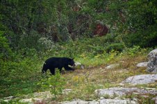
Possibly, they had more than they could handle, or perhaps they were trying to bring a bear in for their next trip in, with it being after Labour Day the canoe trippers wouldn't be coming anymore and a bear would be a bonus. Stupid as it is though as it would spoil the campsite. Maybe they dropped a tub and were in a hurry to get going so left them. The ugly truth might be they are Treaty Indians and doing netting on the lake, thus they can take as much as they can carry. I have a partial of their licence plate as well as description of their truck which we intend to pass on to the conservation authorities and see if anything can be done.
Carry on. The storm passed south of us and on we went. We had been 4 hours to this point and had only one more port/wade to go. Only a km upstream is another small rapid not on the map, we lined/waded this on the right side and then make slow travel against the current to our river mouth/lakeside camp.
The 7 ports are in the first 9.5km of the River from the road. It is a tough slog for sure and may be a reason more people don't go up there. We had our usual camp set up duties, I take care of the tent and getting bedding set out, Christine gets the water going and kitchen set up. Before I was done she had the coffee on. 6 hours to go 12.9km.
With rain in the forecast and storms brewing all around us, we set up the tarp we always bring but rarely use. Our rigging would have made Hoop cry but it was sufficient for the first night. Dinner was steak, eggs and toast.
After finally settling in we broke out the fishing rods and crossed the first bay to the narrows where Christine had fished a couple years earlier on a solo trip.
The lake itself is 3 separate bowls with rampant wild rice in the shallows. With this year's higher water there was less congestion of rice and at least half wasn't even ripe yet.
At the narrows we caught the first of many fish for the trip, only spending a half hour before sundown we boated 5 pickerel and 2 pike. The pickerel were a better size than we are used to getting up here, perhaps another bonus of higher water.
After watching a beautiful sunset, Christine had a small fire while I tried to photograph lightning in a distant storm.
As we lay down, a Whip-poor-will took roost above us and started it's chant, getting another to return it's call. We both groaned and wondered if this is the same bird who has been at every other campsite we have had in 7 Summers in Manitoba. It was almost funny but we were so tired we dropped off fast to its call and the honking of hundreds of geese out on the lake.


Rice River, Sept 1-5, 2014
Day 1
The forecast wasn't the best for the first week of September, but we were undaunted. 60% chance of showers and thunderstorms for Monday afternoon, 40% of the same for Tuesday, sunny Wednesday, Rain all day Thursday, sunny and warm on Friday
Rise and shine bright eyed but not so bushy tailed. On the road a bit after 6, got into some dense fog as we neared the Red River but it cleared as we headed further north. It was a bright day to begin with and quite moist as it had rained all of the day prior.
We got up onto the old Winter Road which is being improved and extended to be all season access to the 3 Reserves on the East side of Lake Winnipeg, Bloodvein Village, Berens River and Poplar River. This will be a long term project as it has taken almost 4 years just to get the road to Bloodvein Village, they are just completing the bridge over the Bloodvein River and that part of the road should be open this October.
What we found wasn't in very good shape, many potholes, slick and soft with barely a lane and a half width at most places. It had rained almost daily for the week prior so this is what it will be like normally once open to daily traffic. What we also found is they are cutting a new path to take many of the twists and turns out and will be putting new bridges in where either a 40 year old bridge exists or bailey bridges are in temporarily. Now, they will be able to do those new bridges without disrupting traffic but where it crosses the Rice River, they will be putting the new bridge at the top of the falls at the road and likely eliminate the parking and River access at its present location. It will likely take them a couple more years to put in the new bridges while they extend the road past Bloodvein Village.
As we pulled in to the access we found much more water than anticipated in the river, the highest we have ever paddled it for sure. There was also a truck already at the put in and that just garnered speculation on our part as we unloaded and headed upstream. They could be setting up a moose camp for when the season opens in two weeks or perhaps up at the lake harvesting the wild rice. Maybe just out for fishing like we were. It would turn out to be much more disturbing.
The first rapid is only a km or so up and we did the shorter port on the left, took less than 5 minutes. The actual portage is on the right but the left side is shorter and keeps you from needing to paddle through the current.
The second, third and fourth rapids/falls are not marked on the topo map.
Next up river is a small falls with the port on the left again, it has the best landing and is about 100 paces at the most.
Around a couple turns in the river is the 3rd, which we lined on River left. Last year when we were up here in much lower water, we found a channel which had been built on the left side along the rock wall to allow ease of movement under low water conditions. We just lined up this channel despite the much higher water levels.
It was at this point we saw a canoe coming out. It was heavily loaded and had maybe 4 inches of freeboard. It was 2 First Nations fellows and they had many blue bins loaded in the boat, they were quite jovial and spoke of the excellent fishing...
The next set is what I call the Double Triple. Coming from downstream it sets up like this... a bony rapid with a rock wall on the right side, a pool, a small falls, another pool, then another bony rapid. There are options here. There is a 300m port on the right side below the first rapid which would take you past that and the falls into the middle pool, or, as we did, wade the first rapid then take the port on the left side around the small falls into the pool. Once in the middle pool the take out for the next rapid is on the left and it puts you upstream of the upper rapid. None of the take outs or put ins for this set is good, mostly rock, plenty of logs in the eddies, not much fun and the portages are not maintained nor well used. We blazed where needed.
In lower water, the first rapid has a channel cut on the right and the upper rapid can be waded on the left but the falls must be ported.
There are many necked down areas which are quite bony to contend with as well as a rock garden between 1 and 2 but with our water level we can float over most of it.
Portage 6 has a nice take out river left and a good camp site exists here. There is remnants of either a First Nations or moose camp and we stay here often.
Some history for this site is it used to be a waterfall but at some point in the last 60 years someone wanted to lower the level of the lake to grow more wild rice, so they removed copious amounts of rock here and a little further upstream which increased flow and dropped the Lake level. It is difficult to imagine the manpower it would have taken to create the rock piles seen at the bottom of this Falls.
Halfway up this portage trail with my first load I found a pile of dead pickerel in the middle of the trail/campsite. There were 18 fish total, all dead, some still a bit soft but all a good eating size. Those fellows had just dumped them right there. Mad as hell! Poachers? It must have been fish in all those tubs and sinking their canoe that deep in the water.
We completed our load transfer up trail, disposed of the fish after a couple of photo's and then sat out a passing thunderstorm as we talked about what might be the reason they dumped perfectly good fish.
Possibly, they had more than they could handle, or perhaps they were trying to bring a bear in for their next trip in, with it being after Labour Day the canoe trippers wouldn't be coming anymore and a bear would be a bonus. Stupid as it is though as it would spoil the campsite. Maybe they dropped a tub and were in a hurry to get going so left them. The ugly truth might be they are Treaty Indians and doing netting on the lake, thus they can take as much as they can carry. I have a partial of their licence plate as well as description of their truck which we intend to pass on to the conservation authorities and see if anything can be done.
Carry on. The storm passed south of us and on we went. We had been 4 hours to this point and had only one more port/wade to go. Only a km upstream is another small rapid not on the map, we lined/waded this on the right side and then make slow travel against the current to our river mouth/lakeside camp.
The 7 ports are in the first 9.5km of the River from the road. It is a tough slog for sure and may be a reason more people don't go up there. We had our usual camp set up duties, I take care of the tent and getting bedding set out, Christine gets the water going and kitchen set up. Before I was done she had the coffee on. 6 hours to go 12.9km.
With rain in the forecast and storms brewing all around us, we set up the tarp we always bring but rarely use. Our rigging would have made Hoop cry but it was sufficient for the first night. Dinner was steak, eggs and toast.
After finally settling in we broke out the fishing rods and crossed the first bay to the narrows where Christine had fished a couple years earlier on a solo trip.
The lake itself is 3 separate bowls with rampant wild rice in the shallows. With this year's higher water there was less congestion of rice and at least half wasn't even ripe yet.
At the narrows we caught the first of many fish for the trip, only spending a half hour before sundown we boated 5 pickerel and 2 pike. The pickerel were a better size than we are used to getting up here, perhaps another bonus of higher water.
After watching a beautiful sunset, Christine had a small fire while I tried to photograph lightning in a distant storm.
As we lay down, a Whip-poor-will took roost above us and started it's chant, getting another to return it's call. We both groaned and wondered if this is the same bird who has been at every other campsite we have had in 7 Summers in Manitoba. It was almost funny but we were so tired we dropped off fast to its call and the honking of hundreds of geese out on the lake.


Last edited:


")