• Happy Founding of The Wilderness Society (1935)! 🏔️🏜️🌲

Inukshuks, Cairns or Rock Piles: What to Do or Not Do?

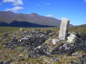
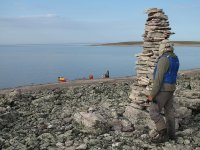
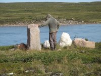
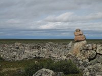
Kathleen and I paddled the Thelon River in 1993, and encountered many Inuit structures along Aberdeen Lake. The word “inukshuk” means “in the likeness of a human.” For generations, Inuit have been creating these impressive stone markers on the vast Arctic landscape. Inukshuks serve several functions, including guiding travellers, warning of danger, assisting hunters and marking places of reverence.
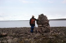
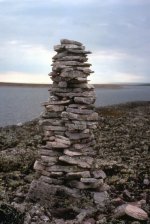
Thelon109 resize.jpg

Thelon110 resize.jpg

Wr read that hese stone pillars (Inukshuks) were used as directional aides, or as markers to guide the caribou to slaughter. Stretching out in a lengthy “V” across the tundra, the pillars appeared as groups of men. The caribou, would be guided to cross narrow sections of the lake or river, where they could be more easily killed by Inuit in their kayaks.

We admired these historical creations, and certainly never thought to destroy them!!!!
 
For generations, Inuit have been creating these impressive stone markers on the vast Arctic landscape. Inukshuks serve several functions, including guiding travellers, warning of danger, assisting hunters and marking places of reverence.
I mentioned this interpretation in my OP. But I wonder how we really know why many of these rock piles were built by ancient, and how ancient, peoples. Maybe some were built by a lonely hunter or family group just for amusement—like a snowman or an Erector Set or Legos—in an absolutely barren wilderness with nothing else to do after dinner in the land of the midnight sun.

as markers to guide the caribou to slaughter. Stretching out in a lengthy “V” across the tundra, the pillars appeared as groups of men. The caribou, would be guided to cross narrow sections of the lake or river, where they could be more easily killed by Inuit in their kayaks.

This is interesting. I don't see how isolated inukshuks could perform this function. The research indicates that long lines of inukshuks, cairns and stone walls were built, often embedded within V-shaped or other funneling topography, to direct the caribou herds to kill blinds on land or hidden kayaks on a shore. Here's a PDF research article:


This next article describes how:

"As a herd of caribou approached, women, children, and elders who were not hunting moved in behind the animals, carefully driving them between the lines of scarecrows, and then urging them along until finally the herd entered the water.

"This was the moment the hunters had been waiting for—sitting in kayaks tucked out of sight against the lakeshore or under a concealing riverbank. Their specially designed inland kayaks (qayaq) were long and narrow, built for maximum speed. Once the caribou started swimming, hunters swiftly paddled after them, came up alongside, and killed the animals with spears.

"Importantly, caribou do not sink like most other animals because their coats are made up of hollow hairs, with tiny pockets of air providing buoyancy. Hunters could get large numbers of caribou and then tow them ashore. Then everyone in the camp worked to butcher the caribou and preserve the meat, either by drying it in the open air or by freezing."

 
I've seen (and mostly abhor, and commonly knock down) cairns throughout the western US--sometimes as something "cute", other times misplaced and leading the follower places he/she really doesn't want to go, and also as legitimate trail demarcations on rock trails where there are no alternatives (no trees, no trampled vegetation). However I have a lot more respect and tolerance of those cairns/inuksuk of the Barrens of Canada. There they are functional tools laid down through generations on lands owned by the people inhabiting them. They provide points of bearing in a pretty bleak, monotonous environment; denote campsites not visible from a river; provide cover for caribou hunters; as well as functions known only by them.
Here's some good background to true inuksuks Inukshuks.

Thelon River--probably the same inuksuk Pitt posted.
sized_IMG_3039.JPG

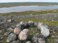
More Thelon inuksuit:
sized_IMG_2894.JPG
sized_IMG_2892.JPG

Inuksuk on the Tha Anne River, Nunavut
sized_38-1408.JPG
 
Last edited:
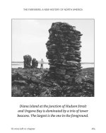
I just finished reading The Farfarers by Farley Mowat. In it he lays down a convincing argument for a wave of European settlement ahead of the Vikings. It describes the cairns similar to the ones photographed above on many of the landfalls and as guides along routes (ie the Kogaluc River approach to Payne Lake while crossing Ungava Peninsula). These mimic structures found in Scotland and Ireland and are way more than 1,000 years old. I would ask that everyone leave the construction and/or destruction of cairns to someone in authority. Screenshot_20231023_101400_Kindle.jpg
 
Possible, I suppose. I went past a week or so ago and he hadn't started building yet so I think it's a summertime thing for him.

Personally, I was impressed by the symmetry and the scale considering that he grew up there but now lives an hour or so away. Also a bit baffled by the amount of time spent knowing that the spring rains will obliterate it completely. (to each his own, I suppose)
 
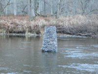
On a related note. Last year floating the Klamath River in California, the second largest river in the state we ran into 5 sets of old bridge abutments. They may have been for roads or railroad crossings. Four of them were old and were no longer holding up anything. They had vegetation growing on them. One set had trees growing on top of them. They were serious hazards to navigation in fast water. The worst of all were the large abutments created at the crossing of Interstate 5. They were close to being perpendicular to the flow of the river. In normal conditions they would be easy to paddle around. In high water they were really dangerous.

Two out of five of these hazards were mentioned in the guide books. This is the kind of stuff that makes me no longer interested in running white water. The man made obstacles were the most dangerous part of the trip. It was too fast for canoes. We used drift boats and still had all we could handle.
 
It's a pretty rare thing in my area - outside the Boise River through the populated areas. I don't care about those. They'll be demolished by the river every spring. In the outback, I just don't ever see them. If I ever do, it's likely that I'll kick it down. I'm pretty sure they have no cultural value here.

As for trail marking....back in the primitive times of my youth, I would use trail tape to mark my way back to the rest of the meat when packing out the first quarter of an elk. On the last trip out, all those trail markers came with me. These days, that's generally accomplished with gps. Otherwise, maps and compass do the job just fine in this part of the country - although I recognize that isn't the case everywhere.

That leads me to the conclusion that the answer for a given area is to ask the land manager about the local policy. Places I already know about, if I see old trail ribbons, I will pull them down. OTOH, when I took a walk around Devil's Tower (hate that name BTW) I noted the sign explaining the religious nature of the ribbons, feathers, etc tied to tree limbs at various locations around the base of the rock. Those are to be left alone, and if one is to be respectful, not even photgraphed.

So I guess the answer is - if there's no sign, ya gotta ask. I would prefer to have to ask or consult the land management website at least, but unfortunately in popular accessable places, we have to tolerate signs.
 
As much as signs of this suburban scene irritate me I never actually knock anything down. I'd feel more of a vandal than an eco warrior.
Maybe these peeps have just grown up (a little) from their beach days of building sand castles. I don't kick them down either.
Like clootie trees and love locked bridges some people just wanna be loved and remembered, and are perhaps searching for something more meaningful out there, somewhere. But I think there are better ways of doing that than littering the world with mini-shrines. Established shrines like established route markers are entirely different and IMO ought to be respected enough so that at the very least we might just let them be.
I don't get whatever that individual was doing when they marked the earth with their own version of creativity but I don't feel entitled to judge their beliefs irrelevant. I will live and let live, tho' I will rant about it. Where I trip I see old blazes and some tape, all of which I respect obviously, as well the pictographs still revered by some and misunderstood by many, valuable cultural parts of a once whole turtle island. Infrequently we come across modern jumbles of rocks, mostly on promontories or campsites, like the ones you'd see along some of our near north highways. These I question their purpose and value but leave them alone. Was some passing tourist letting their children play or did some worried soul leave their message behind? They look silly to me but maybe this is just one more thing I don't get. It's easier to let them be.
There's a tree deep in a forest amongst rolling lands and sheltered places. I won't tell you where it is but if I'd a mind to (which I never will) I could lead you straight to it. On it was almost carved BL loves MP. The young man couldn't bring himself to deface such a beautiful specimen of nature merely to express his exquisite pain. So instead he pocketed his knife and lived his life hoping his girl would always know. I remind her every day.
 
Back
Top