Allagash Lake in Maine was the last piece of the Allagash Wilderness Waterway puzzle I had not dipped my paddle into. https://www.maine.gov/dacf/parksearc...ze/aww-map.pdf
After getting Covid tested so that I could legally enter Maine without having to quarantine for 14 days, I departed Maryland on the Friday of Labor Day weekend and made the 490 mile drive to my mom's house in the town of Kittery, which marks the southernmost extremis of Maine and what real Mainers refer to as "Northern Massachusetts".
After spending the Labor Day weekend with my mom, I departed Kittery on Tuesday, September 8, to drive the remaining 325 of 326 miles to Allagash Lake. That last mile? A reportedly easy portage that would be my first-ever portage to be worthy of the name -- although I intended to cheat and use a small canoe cart to make things even easier!
The drive from Kittery to Millinocket, where the pavement ends, was uneventful. Once I got on to the North Maine Woods logging roads, however, I was slightly anxious about logging trucks and flat tires. I needn't have been. I only experienced one of the former and none of the latter.
I arrived at Telos Checkpoint around 1 pm and the woman issuing permits looked concerned when I told her I was going to Allagash Lake. She pointed to a handwritten note taped to the desk in front of her: "ALLAGASH LAKE ACCESS VIA PORTAGE TRAIL ONLY." I told her that was my plan anyway and that I had even brought a cart for that purpose and she said I was smart because the alternative access, which is via Allagash Stream, was too dry due to the on-going drought up there. I still had another hour and a half drive ahead of me, so I quickly paid my fee ($84.20 including access and five days/four nights of camping), thanked her and got back underway.
(Note: To guide me from Millinocket to Allagash Lake, I used Gaia GPS for the first time on this trip. You could use AppleMaps or Google Maps, but if you turn off your phone up there, when you turn it back on you will no longer have a map or guidance due to the lack of cellular signal. You can download maps from Gaia and they work perfectly when your phone comes back on. Gaia also displayed on my car's screen using CarPlay, so I could watch the little arrow designating my location as I followed my pre-highlighted route. I took my Delorme Maine Gazette/Atlas with me as a back up, but I needn't have. Here's a link to my Gaia track. The blue line is the one I followed along the logging roads to get to Allagash Lake. The purple one is the track of my trip from Ede's to Ice Cave, described below. https://www.gaiagps.com/map/?loc=11....dEfKxZUzf& trackId=fb21d2bf33f227194b2940f60efa6d0e )
Finally, around 2:30 pm, I found myself parked by a locked yellow gate with a sign announcing that motors of any kind were not permitted past the gate (at least until October, which seems weird unless it is to allow snowmobiles). I noted and was sad to see another vehicle there. But at least it was only one other vehicle; and perhaps it was the ranger's truck (I had heard there was a ranger cabin on the lake).
I quickly strapped my cedar strip canoe on top of the canoe cart, threw my gear packs into my canoe and started down the stub of the access road toward the portage trail and the great unknown. Almost immediately I was having issues with the canoe cart. In my haste to get going, I had put one belly strap around the canoe and the cart. That might have worked on a nice paved road, but on the rock-strewn lunar-like surface of this "dirt" access road, this arrangement was not working. The rocks were too numerous to dodge and they worked like wheel chocks on the small wheels of my cart, skewing the cart under the canoe. A smarter man would have stopped right then and there and done a better job of rigging the cart. But I was not a smarter man. It was to be a bad decision on my part.
Eventually, the lunar-like surface of the dirt road ended and the portage trail disappeared into the lush forest surrounding Allagash Lake. Here, at last, was a nice, soft, nearly level grassy portage trail! Carting this trail would be a piece of cake! And it was! For perhaps 100 yards. After that, the portage trail transitioned from grass to dirt, to a rock strewn, rut infested, root festooned hellscape with several short but steep drops that I would rate at Class II+ if water had been flowing over it. (This raises the question: why aren't portage trails rated with a similar system to our whitewater rating system?). Once again, I was having difficulty with the cart. And then it happened. A rock caught a tire, stopped it dead, the cart pivoted under the canoe, and the entire, fully loaded canoe tipped over on its side, spilling my packs, paddles and odds and ends on the side of the trail.
With my canoe resting on its gunnel, I cursed, righted the canoe, tightened the belly strap around the cart as tight as I could, reloaded the canoe with my gear and started off. Within a few minutes, however, it happened again. And then again. And yet again. And again once more. On the fifth occurrence, I had, at last, had enough of the f*%$@&! cart. Grabbing my gear in my hands and tossing the larger of my two packs on my back, I decided to portage the rest of the way to the lake the old fashioned way. Which was just as well, because I was probably only 300-400 or so feet from the lake and the last 100 feet or so were probably the steepest and worst part of the trail. Going back for the rest of the gear and my canoe, which I tossed onto my shoulders using the carrying yoke, I was already thinking about how difficult the mile long portage back would be, especially since it was almost entirely uphill! I'd have to figure something out with the f*%$@&! cart.
But for now, at least, I was safely at the far southern end of Allagash Lake, and the view was already making me forget the portage! The trail had dumped me out right next to the ranger's cabin, which was locked and empty. The vehicle I had seen in the parking lot meant there was someone else on the lake.
I had planned on paddling the length of the lake to go either to Ice Cave or Ledges campsites. But by the time I actually put my paddle in the water it was already after 4 pm and I wanted to set up camp in daylight. So I settled on Ede's, which is the second-most southerly camp on the eastern shore, perhaps only a half a mile or so from the lake's southern end. Ede's is a small, once cell site with a magnificent southwesterly view of the lake's more mountainous southern and western shore. The fire pit and outhouse there were either just cleaned or had not been used much or at all that summer! What a pleasant surprise after all the Adirondack over-usage stories I have read this summer!
I set up my tent on a grassy tent pad with a view of the lake, ate a quick freeze-dried dinner out of the pouch and got ready to retire for the evening. Just before the last of the light faded, I noticed a bit of campfire smoke wafting up from the southern end of the lake where I had just been, but more to the east of the ranger cabin. The only campsite in that vicinity was Carry Trail (just before the lake, the portage trail splits, and the right fork is labeled Carry Trail), so I assumed the owner(s) of the parked truck I had seen back at the gate were camping there for the evening.
It rained moderately overnight. Wednesday morning, I was feeling lazy after breakfast and not much in the mood for paddling. Instead, I walked the shore quite a distance, read my book down by the lake and processed a small amount of firewood with my homemade bucksaw and small forest axe, hoping to enjoy a campfire later that evening.
About an hour after breakfast, as I sat reading my book, a couple (presumably the folks staying at Carry Trail the night before) paddled past me in an impressively loaded canoe, including a big Yellow Labrador Retreiver. Actually, that is not quite accurate. The couple did not paddle past me. The woman in the stern of the canoe paddled past me while her husband in the bow furiously fished from the front of the canoe, casting left, then right, rinse and repeat. (Reminder to self: make sure my next wife is willing to do all the work of propelling me in fully loaded canoe down a lake while I enjoy a little fishing! "Honey, don't slow down, but would you pass me a beer.").
This was obviously something they did quite a lot because the wife was paddling with the most elegant silent paddle entry I have ever NOT heard -- in spite of the fact that she used an above-water recovery on the stroke. Each entry was was made with the upmost precision of a surgeon's scalpel and it made not a sound. Indeed, there was absolutely not any sound coming from this canoe whatsoever. Even the dog sat completely bolt upright and absolutely motionless and silent -- even as I waved to them as they passed by me sitting by my canoe on the shore. While there was absolutely no way they could not have seen me, I received zero acknowledgement from man, woman or dog. These folks (and dog) were all business and the business was fishing. I watched them paddle/fish their way down the lake until they passed around a peninsula and out of sight. As far as I could tell, no fish were caught. I never saw them again, although their car was still parked by the gate when I left.
Wednesday evening I made a small campfire which I maintained for several hours until the rains came and I retreated back to my tent.
Thursday morning there was a gentle southerly breeze and I decided to take advantage of the conditions and explore some of the lake. Leaving my camp set up at Ede's, my target for the morning was Ice Cave campsite about 3.5 miles away on the western shore of the lake and nearly all the way to the lake's northern end. As I paddled north toward Ice Cave, the gentle southerly breeze turned into a southerly wind and some waves picked up. But in short order I found myself at Ice Cave. Ice Cave is a very nice two cell site on a peninsula, each with a private section of shoreline. Both cells were empty and, again, the fire pits had either recently been cleaned or had not been used all summer.
In the clever way Mainers like to give things descriptive names, the Ice Cave campsite is named for an ice cave that is located a short hike up a hill behind the site. (The same cleverness is why there's something like a half-dozen or more "Round Ponds" along the Allagash Wilderness Waterway). I had brought a flashlight intended to explore the cave. Despite an expansive looking opening, as I made my way into the cave there looked to be an uncomfortable squeeze to be made before getting into a large chamber. I suddenly had visions of slipping and falling and/or getting stuck with no one around to help me and I chickened out.
It's just as well that I skipped the spelunking, because when I returned to my canoe, the slight southerly wind had turned into a legit southerly wind and there were now some real waves on the lake. Not whitecaps, but not the kind of waves you can ignore. The trip back to Ede's would be substantially more challenging than the trip to Ice Cave. Sticking close to shore and ducking behind islands and peninsulas, I made it back without too much difficulty, completing the 7.5 mile round trip. You can see the track I took as the purple line on the Gaia GPS link above. Of course, as soon as I touched shore, the winds seemed to die out on the lake. F*%$ you, wind!
After dinner, however, the wind changed direction and a really fierce wind blew from the west almost all night long.
Friday morning I awoke to a westerly wind, somewhat diminished, that was still blowing. Checking the Dark Sky weather forecast using my new Zoleo satellite messenger (I have a separate review of that unit that I have posted), I could see that the forecast for Saturday was even more wind and more rain. I had planned on leaving on Saturday but the forecast made that seem like a losing proposition. Moreover, I could see that the westerly wind was supposed to shift around to the north, which would be favorable to make my exit to the south. So I made the decision to bug out a day early. I quickly packed up, loaded the canoe and waited for the wind to shift. It never did. So in spite of the westerly winds/waves, I decided to head off to the take out to my south, quartering the waves. It wasn't too difficult a trip. And of course, the moment I reached shore, the winds out on the lake where I had just been died just like a switch had been thrown. F*%$ you, wind!
Now all I had between me and my car was that mile-long uphill portage with the f*%$@&! cart. But I had been pondering the errors of my ways and had fashioned a plan for a bomb-proof way to rig the cart to the canoe so that it could roll over anything without the cart so-much as budging. So, in addition to the belly strap, I tied one of my painters to the cart's frame, and then ran the painter through the lining/towing eye in the bow of my canoe and tied it off to the other side of the cart using a trucker's hitch to cinch it tight. I then repeated this process with the other painter, passing it through the eye in the stern of my canoe. It seemed very secure. But discretion being the better part of valor, I decided to portage my 2 packs up the the first 100 or so yards of the trail in order to avoid the worst of it.
The empty canoe practically floated over this rough part of the trail, which encouraged me enough to throw the packs into the canoe for the rest of the portage. And the rigging held up over hill and dale, rock, root and rut. It was a bit of a slog back to the car but, mercifully, there were no recurrence of the tip overs that had plagued my portage in.
In short order I was back at Telos Checkpoint, turning in my paperwork and on my way back to Kittery where I spent the next 2 days before setting off for Maryland.
So, I realized when I got home that I had endured roughly 1600 miles of round trip driving (about 140 miles on logging roads), and 2 miles of portages (including the five tip overs on dry land), all just to paddle probably a little less than 10 miles in total from the put-in on the southern end of Allagash Lake to Ede's, Ede's to Ice Cave, Ice Cave back to Ede's, and Ede's back to the put-in). A ridiculously small amount of reward for the amount of effort.
But, here's the thing: I don't regret it one bit. Allagash Lake was breathtakingly beautiful and the serenity and the solitude was fantastic (and wasn't even spoiled by the one other canoe I briefly saw on the lake). So, I will go back. Next time, however, I will almost certainly stay longer and explore all the lake has to offer. And I will definitely make sure I rig the canoe cart properly before taking off on the portage trail.
(I will be adding photos to this post).

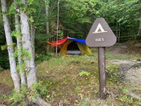
Telos Checkpoint on the way in.

I guess the motor prohibition doesn't apply in the Fall/Winter to get snowmobiles in?
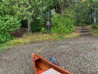
 The view at the put-in after the portage, looking north.

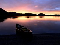
The view from the beach at Ede's looking west.

After getting Covid tested so that I could legally enter Maine without having to quarantine for 14 days, I departed Maryland on the Friday of Labor Day weekend and made the 490 mile drive to my mom's house in the town of Kittery, which marks the southernmost extremis of Maine and what real Mainers refer to as "Northern Massachusetts".
After spending the Labor Day weekend with my mom, I departed Kittery on Tuesday, September 8, to drive the remaining 325 of 326 miles to Allagash Lake. That last mile? A reportedly easy portage that would be my first-ever portage to be worthy of the name -- although I intended to cheat and use a small canoe cart to make things even easier!
The drive from Kittery to Millinocket, where the pavement ends, was uneventful. Once I got on to the North Maine Woods logging roads, however, I was slightly anxious about logging trucks and flat tires. I needn't have been. I only experienced one of the former and none of the latter.
I arrived at Telos Checkpoint around 1 pm and the woman issuing permits looked concerned when I told her I was going to Allagash Lake. She pointed to a handwritten note taped to the desk in front of her: "ALLAGASH LAKE ACCESS VIA PORTAGE TRAIL ONLY." I told her that was my plan anyway and that I had even brought a cart for that purpose and she said I was smart because the alternative access, which is via Allagash Stream, was too dry due to the on-going drought up there. I still had another hour and a half drive ahead of me, so I quickly paid my fee ($84.20 including access and five days/four nights of camping), thanked her and got back underway.
(Note: To guide me from Millinocket to Allagash Lake, I used Gaia GPS for the first time on this trip. You could use AppleMaps or Google Maps, but if you turn off your phone up there, when you turn it back on you will no longer have a map or guidance due to the lack of cellular signal. You can download maps from Gaia and they work perfectly when your phone comes back on. Gaia also displayed on my car's screen using CarPlay, so I could watch the little arrow designating my location as I followed my pre-highlighted route. I took my Delorme Maine Gazette/Atlas with me as a back up, but I needn't have. Here's a link to my Gaia track. The blue line is the one I followed along the logging roads to get to Allagash Lake. The purple one is the track of my trip from Ede's to Ice Cave, described below. https://www.gaiagps.com/map/?loc=11....dEfKxZUzf& trackId=fb21d2bf33f227194b2940f60efa6d0e )
Finally, around 2:30 pm, I found myself parked by a locked yellow gate with a sign announcing that motors of any kind were not permitted past the gate (at least until October, which seems weird unless it is to allow snowmobiles). I noted and was sad to see another vehicle there. But at least it was only one other vehicle; and perhaps it was the ranger's truck (I had heard there was a ranger cabin on the lake).
I quickly strapped my cedar strip canoe on top of the canoe cart, threw my gear packs into my canoe and started down the stub of the access road toward the portage trail and the great unknown. Almost immediately I was having issues with the canoe cart. In my haste to get going, I had put one belly strap around the canoe and the cart. That might have worked on a nice paved road, but on the rock-strewn lunar-like surface of this "dirt" access road, this arrangement was not working. The rocks were too numerous to dodge and they worked like wheel chocks on the small wheels of my cart, skewing the cart under the canoe. A smarter man would have stopped right then and there and done a better job of rigging the cart. But I was not a smarter man. It was to be a bad decision on my part.
Eventually, the lunar-like surface of the dirt road ended and the portage trail disappeared into the lush forest surrounding Allagash Lake. Here, at last, was a nice, soft, nearly level grassy portage trail! Carting this trail would be a piece of cake! And it was! For perhaps 100 yards. After that, the portage trail transitioned from grass to dirt, to a rock strewn, rut infested, root festooned hellscape with several short but steep drops that I would rate at Class II+ if water had been flowing over it. (This raises the question: why aren't portage trails rated with a similar system to our whitewater rating system?). Once again, I was having difficulty with the cart. And then it happened. A rock caught a tire, stopped it dead, the cart pivoted under the canoe, and the entire, fully loaded canoe tipped over on its side, spilling my packs, paddles and odds and ends on the side of the trail.
With my canoe resting on its gunnel, I cursed, righted the canoe, tightened the belly strap around the cart as tight as I could, reloaded the canoe with my gear and started off. Within a few minutes, however, it happened again. And then again. And yet again. And again once more. On the fifth occurrence, I had, at last, had enough of the f*%$@&! cart. Grabbing my gear in my hands and tossing the larger of my two packs on my back, I decided to portage the rest of the way to the lake the old fashioned way. Which was just as well, because I was probably only 300-400 or so feet from the lake and the last 100 feet or so were probably the steepest and worst part of the trail. Going back for the rest of the gear and my canoe, which I tossed onto my shoulders using the carrying yoke, I was already thinking about how difficult the mile long portage back would be, especially since it was almost entirely uphill! I'd have to figure something out with the f*%$@&! cart.
But for now, at least, I was safely at the far southern end of Allagash Lake, and the view was already making me forget the portage! The trail had dumped me out right next to the ranger's cabin, which was locked and empty. The vehicle I had seen in the parking lot meant there was someone else on the lake.
I had planned on paddling the length of the lake to go either to Ice Cave or Ledges campsites. But by the time I actually put my paddle in the water it was already after 4 pm and I wanted to set up camp in daylight. So I settled on Ede's, which is the second-most southerly camp on the eastern shore, perhaps only a half a mile or so from the lake's southern end. Ede's is a small, once cell site with a magnificent southwesterly view of the lake's more mountainous southern and western shore. The fire pit and outhouse there were either just cleaned or had not been used much or at all that summer! What a pleasant surprise after all the Adirondack over-usage stories I have read this summer!
I set up my tent on a grassy tent pad with a view of the lake, ate a quick freeze-dried dinner out of the pouch and got ready to retire for the evening. Just before the last of the light faded, I noticed a bit of campfire smoke wafting up from the southern end of the lake where I had just been, but more to the east of the ranger cabin. The only campsite in that vicinity was Carry Trail (just before the lake, the portage trail splits, and the right fork is labeled Carry Trail), so I assumed the owner(s) of the parked truck I had seen back at the gate were camping there for the evening.
It rained moderately overnight. Wednesday morning, I was feeling lazy after breakfast and not much in the mood for paddling. Instead, I walked the shore quite a distance, read my book down by the lake and processed a small amount of firewood with my homemade bucksaw and small forest axe, hoping to enjoy a campfire later that evening.
About an hour after breakfast, as I sat reading my book, a couple (presumably the folks staying at Carry Trail the night before) paddled past me in an impressively loaded canoe, including a big Yellow Labrador Retreiver. Actually, that is not quite accurate. The couple did not paddle past me. The woman in the stern of the canoe paddled past me while her husband in the bow furiously fished from the front of the canoe, casting left, then right, rinse and repeat. (Reminder to self: make sure my next wife is willing to do all the work of propelling me in fully loaded canoe down a lake while I enjoy a little fishing! "Honey, don't slow down, but would you pass me a beer.").
This was obviously something they did quite a lot because the wife was paddling with the most elegant silent paddle entry I have ever NOT heard -- in spite of the fact that she used an above-water recovery on the stroke. Each entry was was made with the upmost precision of a surgeon's scalpel and it made not a sound. Indeed, there was absolutely not any sound coming from this canoe whatsoever. Even the dog sat completely bolt upright and absolutely motionless and silent -- even as I waved to them as they passed by me sitting by my canoe on the shore. While there was absolutely no way they could not have seen me, I received zero acknowledgement from man, woman or dog. These folks (and dog) were all business and the business was fishing. I watched them paddle/fish their way down the lake until they passed around a peninsula and out of sight. As far as I could tell, no fish were caught. I never saw them again, although their car was still parked by the gate when I left.
Wednesday evening I made a small campfire which I maintained for several hours until the rains came and I retreated back to my tent.
Thursday morning there was a gentle southerly breeze and I decided to take advantage of the conditions and explore some of the lake. Leaving my camp set up at Ede's, my target for the morning was Ice Cave campsite about 3.5 miles away on the western shore of the lake and nearly all the way to the lake's northern end. As I paddled north toward Ice Cave, the gentle southerly breeze turned into a southerly wind and some waves picked up. But in short order I found myself at Ice Cave. Ice Cave is a very nice two cell site on a peninsula, each with a private section of shoreline. Both cells were empty and, again, the fire pits had either recently been cleaned or had not been used all summer.
In the clever way Mainers like to give things descriptive names, the Ice Cave campsite is named for an ice cave that is located a short hike up a hill behind the site. (The same cleverness is why there's something like a half-dozen or more "Round Ponds" along the Allagash Wilderness Waterway). I had brought a flashlight intended to explore the cave. Despite an expansive looking opening, as I made my way into the cave there looked to be an uncomfortable squeeze to be made before getting into a large chamber. I suddenly had visions of slipping and falling and/or getting stuck with no one around to help me and I chickened out.
It's just as well that I skipped the spelunking, because when I returned to my canoe, the slight southerly wind had turned into a legit southerly wind and there were now some real waves on the lake. Not whitecaps, but not the kind of waves you can ignore. The trip back to Ede's would be substantially more challenging than the trip to Ice Cave. Sticking close to shore and ducking behind islands and peninsulas, I made it back without too much difficulty, completing the 7.5 mile round trip. You can see the track I took as the purple line on the Gaia GPS link above. Of course, as soon as I touched shore, the winds seemed to die out on the lake. F*%$ you, wind!
After dinner, however, the wind changed direction and a really fierce wind blew from the west almost all night long.
Friday morning I awoke to a westerly wind, somewhat diminished, that was still blowing. Checking the Dark Sky weather forecast using my new Zoleo satellite messenger (I have a separate review of that unit that I have posted), I could see that the forecast for Saturday was even more wind and more rain. I had planned on leaving on Saturday but the forecast made that seem like a losing proposition. Moreover, I could see that the westerly wind was supposed to shift around to the north, which would be favorable to make my exit to the south. So I made the decision to bug out a day early. I quickly packed up, loaded the canoe and waited for the wind to shift. It never did. So in spite of the westerly winds/waves, I decided to head off to the take out to my south, quartering the waves. It wasn't too difficult a trip. And of course, the moment I reached shore, the winds out on the lake where I had just been died just like a switch had been thrown. F*%$ you, wind!
Now all I had between me and my car was that mile-long uphill portage with the f*%$@&! cart. But I had been pondering the errors of my ways and had fashioned a plan for a bomb-proof way to rig the cart to the canoe so that it could roll over anything without the cart so-much as budging. So, in addition to the belly strap, I tied one of my painters to the cart's frame, and then ran the painter through the lining/towing eye in the bow of my canoe and tied it off to the other side of the cart using a trucker's hitch to cinch it tight. I then repeated this process with the other painter, passing it through the eye in the stern of my canoe. It seemed very secure. But discretion being the better part of valor, I decided to portage my 2 packs up the the first 100 or so yards of the trail in order to avoid the worst of it.
The empty canoe practically floated over this rough part of the trail, which encouraged me enough to throw the packs into the canoe for the rest of the portage. And the rigging held up over hill and dale, rock, root and rut. It was a bit of a slog back to the car but, mercifully, there were no recurrence of the tip overs that had plagued my portage in.
In short order I was back at Telos Checkpoint, turning in my paperwork and on my way back to Kittery where I spent the next 2 days before setting off for Maryland.
So, I realized when I got home that I had endured roughly 1600 miles of round trip driving (about 140 miles on logging roads), and 2 miles of portages (including the five tip overs on dry land), all just to paddle probably a little less than 10 miles in total from the put-in on the southern end of Allagash Lake to Ede's, Ede's to Ice Cave, Ice Cave back to Ede's, and Ede's back to the put-in). A ridiculously small amount of reward for the amount of effort.
But, here's the thing: I don't regret it one bit. Allagash Lake was breathtakingly beautiful and the serenity and the solitude was fantastic (and wasn't even spoiled by the one other canoe I briefly saw on the lake). So, I will go back. Next time, however, I will almost certainly stay longer and explore all the lake has to offer. And I will definitely make sure I rig the canoe cart properly before taking off on the portage trail.
(I will be adding photos to this post).
Telos Checkpoint on the way in.
I guess the motor prohibition doesn't apply in the Fall/Winter to get snowmobiles in?
The view at the put-in after the portage, looking north.The view from the beach at Ede's looking west.
Last edited: