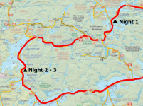
Day 1 : Cedar Lake to Catfish Lake
TOTAL KM: 16.7 KM |
# OF PORTAGES (DISTANCE): 5 (3.6 KM)

Every time we had have been to Access #27 the volume of fellow trippers has been light. Part of the lure of the Northern part of Algonquin is the remote feel to the big lakes. We avoid highway 60 as much as possible in the summer months, and prefer to make the longer drives to find our solitude. With that said, when we stopped at the permit office off of HWY 17 we were told to find the warden at the put in. Apparently they were going to help us, and hopefully he can find a parking spot for us. This was completely unexpected, and had us worried during the 45 -50 minutes driving drive towards Cedar.
We rolled into the Cedar Lake campground and found it absolutely swarming with people. Every campsite was full, and the put in looked like a car dealership. We did spot at least one open parking spotspace, so we wasted no time unloading. so we elected to pull We pulled the truck up by the dock beach on the beach to unloadand unloaded the canoes and gear neatly beside the dock. Within minutes of arriving, a whitean Ontario Park’s truck pulled wheeled over, and the ranger asked us for permits. Apparently the interior was also quite full, with most lakes booked nearly solid from Cedar to Burntroot. We were directed to take the final parking spot (the other one was taken while we unloaded) and they headed on their way. We finished unloading and were greeted by a couple who who had recognized us from You Tube. Paul and his wife were headed up the Petawawa as well. Very nice people and a cool experience. That being said, with the news that the park is nearly full, it was now a race whether Paul knew it or not… Joking aside, we had our eyes set on a few campsites in the South end of Catfish Lake and we wanted to start hustling our way down there.
Eric and Ryan prepped the boats while Evan and Rich headed off down the road to see if the Algonquin Outfitters store was open. Evan wanted to see if Jake Pigeon was still working, and maybe see the boxcar remnants on the way back. This side trip ended up being a waste of time. The office did not appear to be open, and while walking the tracks we did not find the box car. We didn’t search very long though. In our rush we , had not brought the map, and in the back of our minds we were already thinking about crossing Cedar.

We pushed off around 0900-0930, a little later than we had hoped, but the lake was still relatively very calm. It was a B bright, beautiful day with a slight prevailing breeze coming blowing from down from the Northern arm of the lake. When the lake is behaving the crossing to the first portage is easy. Once we were a little over halfway when we noticed an aluminum boat heading angling to pass right in front of us. As the boat approached, it looksed like it was going turning directly into our path!. This confused us and, wondering we wondered if somehow the driver did had not seen us. What we failed to realize, and were least not expecting, was a visit from anotherANOTHER set of wardens! Rarely do we run into rangers or wardens on our trips, let alone two instances. They were friendly, and so after the obligatory life jacket, boating safety equipment, and permit check, we talked about good fishing holes on Catfish. They also tried to prepare us for the calamity we were about to experience on the P715. There was a large LARGE group of inexperienced campers that were stating squatting on the portage into the Petawawa,. who They were apparently holding a permits for a lake 2-3 days travel further South but had yet to make it that far. We gathered that the rangers had already ticketed the parties involved, but were unable to really do anything about this roving band of off permit campers. The warden warned us to stay on permit, and to try to get a head of the group as fast as possible, to avoid being displaced ourselves. I don’t know what we expected to see at the portage, but what we saw was not it!
As we approached we saw an inflatable dingy , 5-6six canoes pulled partly on to shore, and seemingly dozens of people milling about. There was a tent set up (partially?) between the portage and the end of the rapid and many people sitting in camp chairs all over the landing. This is the exact thing we hope to avoid on any of our trips, and not something we expected to see inside of 30 minutes. We noticed Paul and his wife, and another couple further up the trail about to start their portage. We couldn’t land on shore with the mass of boats, so we just jumped out in the shallows, tossed on our bags, and carried the boats right out of the water, around the canoe jam, and on to the portage trail.
Typically, I really like this portage. It is a nice warm up for the future portages of the day. It has just enough incline to remind you that portaging food and gear is not always fun, with an awesome waterfall to remind you that tripping is nearly always fun! Water levels have had been high all year, so the falls was were loud and violent. There is a well marked trail at the top of the falls to the right of the canoe rest. This is an obvious place to view the falls from the top. I also prefer to take a small side path down to the bottom of the falls to really give yourself the immersive experience. We did couldn’t afford to linger long at the falls though. There was a steady stream of campers coming up the hill from Cedar, presumably on their 4-54th or 5th carry of the morning based on the sheer amount of gear they had. We did not want to get caught up in another circus at the top end of the portage. We reached the Petawawa and were greeted by the other couple we had seen earlier from the lake. They were also shocked by the situation we all had just experienced and mentioned their plan to make camp on Narrowbag Lake, and were going to Narrowbag to make camp. We wished them luck, and gladfully happily pushed off on to the Petawawa River.
This section of the Petawawa River, and the section after the P300, is wide and not overly interesting. You are paddling against the current, but you don’t really notice. On previous trips we had seen moose in this section, and also battled strong head winds in addition to the current. Neither of those things were experienced on this trip. Just a quiet paddle with the sun beaming down. The P300 goes around another large waterfall, with another trail at the top for viewing. It is much more difficult to traverse to the bottom of this set of falls though, so we didn’t bother. We met a French man and his daughter (we assumed) while on this portage. They were heading to Catfish as well, and were actually doing the same loop as us but over 8 or 9 days. We cracked a few jokes and, wished them good luck., We pushed off and took the lead in the great race to Catfish Lake!
Our next feature for the day was the P2345 and the dreaded “Unicorn Hill”. After having done this portage multiple times, we knew what to expect. As far as named portages go, this one is easier than “Heart Attack Hill” and “Stairway to Heaven”. The worst part about this portage is the distance you have to carry just to get to the bottom of the hill, and then the incline itself is more of a leg/lung burning incline over an extended period. The other downside is we are normally on day one of a trip, meaning we are carrying 7 daysa week’s worth of food and, booze, and gear. We single carried to the top, passing two more groups on their way down, and stopped for a quick breather at the top. We noticed that the canoe rest at the top of the hill is no longer present, but the mosquitos certainly were. Once you crest the top of the hill, the portage is much easier. It is still over 1 kilometre to the put in, but the trail is wide and feels like it is flat comparatively. While we rested and chatted at the put in the French pair joined us after the first leg of their single carry. We chatted some more with them, joked joking about how light our Kevlar boats are compared to theirs, and hydrated. We even let the Frenchman know that if he managed to find us on Catfish tonight we will have a beer waiting for him. The worst of the day was now over, so we prepared for an afternoon mostly spent paddling.
We paddled the pond between the portages, and completed the P170. This portage is essentially an incline to the road, and then a decline to the lake. We saw some signage, I believe you can extend the P2345 on the south side and just walk the road over the bring bridge to the second half of the P170. Might be worth the effort of not having to load and upload the boats at the pond… and the walk would be flat. Food for thought.
As we were putting into Narrowbag we crossed paths with another two canoes leaving the lake. Man the interior was feeling a little too busy. We talked to the Dad and kids for a short period, mostly about fishing. Somehow we got talking about the Bay of Quinte (where we live) and he mentioned selling a trolling motor to a dairy farmer out our way. In a true example of small town living, we mentioned our friend’s name and sure enough, he had recently sold him a motor. Small world.
Evan fished the weed beds and narrows before the campsite, catching only a few Fallfish. We were going to stop for lunch at the campsite on Narrowbag (if open) but decided to push on and eat at the P80 instead. The campsite on Narrowbag looked poor with tons of weeds and lily pads at the shore.

We ate quick, and also fished the bottom end of the P80. Not even a nibble. Ryan and Evan told the story about how they became wind bound on this portage many years earlier and had wrongfully set up camp there. There used to be a built up firepit at that time, and it appears that the pit was removed and then hastily remade.
 Note: This is not a campsite, the next campsite is on Catfish right around the corner.

We started our paddle on Catfish with hopes to be camping on Shangri La (preferably) or the campsite on the shore close by. We headed to the island with the Alligator remains. Evan had been to this island 3 other times, with the first time being fairly traumatic. Back in 2014, on his day one of a scheduled week long trip to Algonquin, Evan’s cousin Greg managed to step on an old metal spike sticking up from the ground when looking at the Alligator. The spike went through his boot and most of the way through his foot. This resulted in a painful night of bush medical care, Whiskey, and painkillers This was, followed by a very long day of paddling, hiking, and driving to the Pembroke hospital. With that in mind, we were very careful when inspecting the rusting rusted Alligator remnants. Only the metal parts are left at this spot, it is not as well preserved as the remnants located in the Southern bay on Burntroot. Pretty neat none the less. Still worth seeing, just mind your footing!


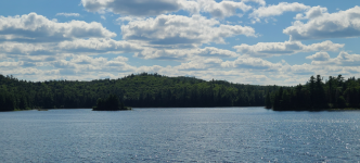
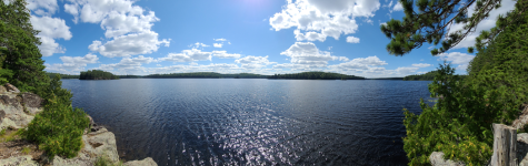
Catfish Lake feels like two separate lakes. The Northern end is much smaller, with nice views to the NW and islands in the South. You access the Southern end of the lake through a narrow channel and then the second half of the lake really opens up. The Northern arm takes you to Lynx Lake and the Luckless Lake portage, but we have never been up that way. We passed by Turtle Rock, where Evan tried to troll per the ranger’s advice (nothing!), and as we turned the corner our destination came into view.


We passed a really elevated campsite on the left shore as we made our way south, noting it was empty in case we had to come back. We kept our eyes peeled for any movement or people on
Shangri La Island. As we angled towards the middle of the lake, to swing the island on the right hand side, we saw our first sign of people. We were disheartened, but at the same time thankful that someone had decided to walk out onto the rocks for a moment, saving us more paddling! We linked up our canoes, checked the map, and decided we would return to the rocky, elevated campsite North of Shangri La.
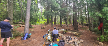
This campsite is very unique. There is a very small beach amongst the rocks at the bottom of the campsite. If you take the path into the trees you can get to the thunderbox if you take a left. You need to take a right and embrace your inner mountain goat to get to the main campsite. Once on top of the site you discover y three tiers of campsite. The top, where there is a nice flat rock and limited tent area, the middle shelf where we set up our chairs and sat on the ledge all evening, and the bottom tier where a huge rock firepit is nestled. No matter where you are on the campsite you have a spectacular view of the lake, made even better by the elevation. We hung our 4 hammocks all over the site, basically anywhere we could find suitable trees. We sat in our chairs and enjoyed the rest of the afternoon / evening drinking beverages and watching canoes pass by. Evan named this campsite the “Eyrie” as we must have looked like a flock of birds perched up in our nest to the people paddling by. Dinner was our classic first night meal; marinated beef skewers, twice baked potatoes, and mushrooms. Like always, Rich had outdid himself on that meal, and with Ryan’s help, cooked it to perfection. It had been an interesting start to the trip. Not quite what we were expecting or hoping for but in the end we had made it to where we needed to be. We had even, and found another excellent campsite to add to our inventory. Most importantly, we were set up nicely perfectly to head out the next day to Red Pine Bay. Hopefully no one needed to use the Thunder Box in the middle of the night, it would be a steep stumble in the dark!
DAY ONE VIDEO:


") which is a rarity in beautiful Algonquin. I have to plan my next trip (solo) up there for the end of August. I've got 7 days to explore and do some photography, just need to decide which route ??
which is a rarity in beautiful Algonquin. I have to plan my next trip (solo) up there for the end of August. I've got 7 days to explore and do some photography, just need to decide which route ??