• Happy Sacagawea Day! 🧭🧑🏽‍🍼🪶🏞

Oopsie moments, or at least almost "oopsie"?

Joined
Jul 22, 2023
Messages
189
Reaction score
191
Location
Portland, Oregon
A post in a thread several days back made me think of an image or two in this slide sequence one of the other participants took of my wife and I on the Rogue River in Southwest Oregon years back (Late June, 2006), one of the few runs on that river that we paddled together OC2. I no longer remember the thread or which post brought up the memory, so I'll just start another thread and see if anyone else wants to add their own "OOPS" moments to it. It may have been on tying bags in for whitewater vs flatwater, but no longer sure. Could have been a tangent in a thread. Anyway . . .

This river section is the standard "wilderness run" on the Wild and Scenic stretch from Graves Creek to Foster Bar, which I've mentioned in other posts here. This run pictured is of the fish ladder "sneak route" around Rainie Falls, which is reached the first day of this run, being as it's only about a mile and a half or two below the put-in. Rainie Falls is normally about a 6-foot or more drop on the left side and usually into a big hole at the bottom. Height and intensity vary with water level. There's the "middle chute" to the right of the falls itself, a little less intense than the main falls, but very narrow, especially for rafts. The fish ladder way over on river right was blasted by a pioneering river runner back in the early 1900s to make the river navigable for his guided fishing trips. He also dynamited parts of Blossom Bar Rapids downstream and likely at least a few other drops between.

There are nine images here, and I'll just post them all, though some of the early ones are probably a bit redundant and not needed. The photographer is standing on river right down at the bottom of the narrow run. The opposite bank seen in the pics here is actually an island and "middle chute" and the main falls runs are on the other side of the island, obscured in thse images. Sorry, I can't find a pic of either of them. You can find YouTube vids online of many runs of all three of these routes if interested.

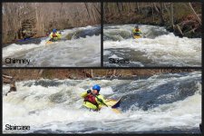
Here are the first three shots in the sequence. The run looks narrow and rocky and it is up top. I thought we were at a higher than normal water level, like 6,000 cfs or higher, but the historical reading of the Agness gauge near the takeout indicates it was between 3600 and 3700 CFS during our run. It can get below 2,000 CFS in the late summer before the winter rains kick in, and has been really high at times in the past. For instance, the gauge hit 129,000 CFS in December, 6 months before our run, and in December 1964, a huge storm that hit much of the West Coast sent the guage up to 290,000 CFS. Really high! My own flow estimation firmware between the ears is rusty these days, but thinks you're looking at maybe 250-300 CFS maximum in the channel here. Anyway:
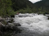
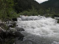
1729721954862.jpeg
1729721994200.jpeg
1729722021315.jpeg

Okay, to there it was just rock picking on the way down, and I was trying to get even farther left than I was. Looks like I'm way left in this next image, but I'm not as far over as I want to be, as here it starts to get a bit dicey.

1729722061344.jpeg

This next pic below is where my wife is starting to wonder about the wisdom of agreeing to the run of this drop. Hey, babe, there's worse downstream! She actually knows that, as she's been on the run before in rafts several times. I have usually paddled this run OC1.

1729722099980.jpeg

This next pic is where she is figuring out she might not want to be here.

1729722144386.jpeg

Our boat here, reasonably heavily loaded with gear already, is now at least half full of water. Notice that the sternman (yours truly) is ready to slap a good low brace. I really wish we were a bit left more as we'd have missed most of the hole(s).

This next image is priceless!

1729722177866.jpeg

You'll notice above that she really doesn't want to be here now. But the lumps are almost over, mostly just a fast short bouncy runout from here, which is good as we're essentially full of water.

1729722238978.jpeg

It doesn't look like the end of the action in the above or next image, but it is smooth right after this one, though I don't have a pic of it.

1729722278830.jpeg

Just bouncy, and smooth water after this one. My end of the canoe doesn't look full, but we did fill it the rest of the way here in these little waves as our freeboard is next to nothing now. The gunnels amidships were under the water soon after this. We paddled the boat to shore (all of 6 feet away?), so close that the photographer couldn't get the whole boat into the frame for the above picture. Just dumped it out and ready to go again.

The boat is a Royalex Dagger Legend 17, a real pig (not only my opinion). We borrowed it for the run to just try it out and hated it. Heavy and real wet in our opinion. We wished we'd have brought the Venture 17 instead (also a Royalex Dagger), but we didn't. We never did flip the boat on the whole run, but were quite lucky in a couple of spots.

That was an "almost oopsie" moment for us. We came through with our upper bodies dry, but not lower bodies. We have gear tied down into the boat, not all of it tight to the floor. There are also air bags in the ends. We don't travel light. We consider trips like this a vacation, not a lesson in deprivation.

Anyone got oops moments of their own to add to this thread?
 
I’ve got lots, but no pictures, and they are faded into the fragmented storage portions of my bean cloud. Falls are the worst, usually after going against my better judgement. I do remember getting onto some windy lakes with a poorly trimmed load. Fishtail surfing in a vicious tail wind in remote Ontario comes to mind. Finally caught a sheltered area to wait out the wind. Relief!
 
Last edited:
Trying to pull a canoe up a small drop. Stern got hung up on a rock slightly sideways and I couldn't push it back to restart. Water was nearly rushing over the gunwale. I couldn't lift the bow any higher. Footing was on the edge of a drop so I couldn't pull it up farther. I gave one last heave to try and dislodge it, failed, water rushed into the boat, and I watched it float away down the river. Thankfully I was wearing my lifejacket so I was able to swim for retrieval.

Alan
 
That's a pretty steep drop, especially with a loaded boat. It's a good thing you had the floatation and had your stuff tied in. It looks like it worked in that situation.
A post in a thread several days back made me think of an image or two in this slide sequence one of the other participants took of my wife and I on the Rogue River in Southwest Oregon years back (Late June, 2006), one of the few runs on that river that we paddled together OC2. I no longer remember the thread or which post brought up the memory, so I'll just start another thread and see if anyone else wants to add their own "OOPS" moments to it. It may have been on tying bags in for whitewater vs flatwater, but no longer sure. Could have been a tangent in a thread. Anyway . . .

This river section is the standard "wilderness run" on the Wild and Scenic stretch from Graves Creek to Foster Bar, which I've mentioned in other posts here. This run pictured is of the fish ladder "sneak route" around Rainie Falls, which is reached the first day of this run, being as it's only about a mile and a half or two below the put-in. Rainie Falls is normally about a 6-foot or more drop on the left side and usually into a big hole at the bottom. Height and intensity vary with water level. There's the "middle chute" to the right of the falls itself, a little less intense than the main falls, but very narrow, especially for rafts. The fish ladder way over on river right was blasted by a pioneering river runner back in the early 1900s to make the river navigable for his guided fishing trips. He also dynamited parts of Blossom Bar Rapids downstream and likely at least a few other drops between.

There are nine images here, and I'll just post them all, though some of the early ones are probably a bit redundant and not needed. The photographer is standing on river right down at the bottom of the narrow run. The opposite bank seen in the pics here is actually an island and "middle chute" and the main falls runs are on the other side of the island, obscured in thse images. Sorry, I can't find a pic of either of them. You can find YouTube vids online of many runs of all three of these routes if interested.

Here are the first three shots in the sequence. The run looks narrow and rocky and it is up top. I thought we were at a higher than normal water level, like 6,000 cfs or higher, but the historical reading of the Agness gauge near the takeout indicates it was between 3600 and 3700 CFS during our run. It can get below 2,000 CFS in the late summer before the winter rains kick in, and has been really high at times in the past. For instance, the gauge hit 129,000 CFS in December, 6 months before our run, and in December 1964, a huge storm that hit much of the West Coast sent the guage up to 290,000 CFS. Really high! My own flow estimation firmware between the ears is rusty these days, but thinks you're looking at maybe 250-300 CFS maximum in the channel here. Anyway:
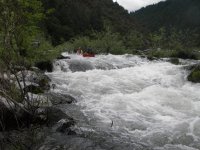
View attachment 143866
View attachment 143867
View attachment 143868

Okay, to there it was just rock picking on the way down, and I was trying to get even farther left than I was. Looks like I'm way left in this next image, but I'm not as far over as I want to be, as here it starts to get a bit dicey.
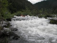
View attachment 143869

This next pic below is where my wife is starting to wonder about the wisdom of agreeing to the run of this drop. Hey, babe, there's worse downstream! She actually knows that, as she's been on the run before in rafts several times. I have usually paddled this run OC1.
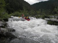
View attachment 143870

This next pic is where she is figuring out she might not want to be here.
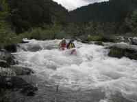
View attachment 143871

Our boat here, reasonably heavily loaded with gear already, is now at least half full of water. Notice that the sternman (yours truly) is ready to slap a good low brace. I really wish we were a bit left more as we'd have missed most of the hole(s).

This next image is priceless!
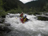
View attachment 143872

You'll notice above that she really doesn't want to be here now. But the lumps are almost over, mostly just a fast short bouncy runout from here, which is good as we're essentially full of water.
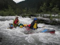
View attachment 143873

It doesn't look like the end of the action in the above or next image, but it is smooth right after this one, though I don't have a pic of it.
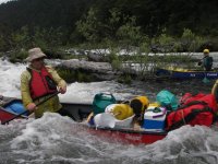
View attachment 143874

Just bouncy, and smooth water after this one. My end of the canoe doesn't look full, but we did fill it the rest of the way here in these little waves as our freeboard is next to nothing now. The gunnels amidships were under the water soon after this. We paddled the boat to shore (all of 6 feet away?), so close that the photographer couldn't get the whole boat into the frame for the above picture. Just dumped it out and ready to go again.

The boat is a Royalex Dagger Legend 17, a real pig (not only my opinion). We borrowed it for the run to just try it out and hated it. Heavy and real wet in our opinion. We wished we'd have brought the Venture 17 instead (also a Royalex Dagger), but we didn't. We never did flip the boat on the whole run, but were quite lucky in a couple of spots.

That was an "almost oopsie" moment for us. We came through with our upper bodies dry, but not lower bodies. We have gear tied down into the boat, not all of it tight to the floor. There are also air bags in the ends. We don't travel light. We consider trips like this a vacation, not a lesson in deprivation.

Anyone got oops moments of their own to add to this thread?
 
That's a pretty steep drop, especially with a loaded boat. It's a good thing you had the floatation and had your stuff tied in. It looks like it worked in that situation.
Thanks Al and others. Yup, it did work just enough. There are other rapids downstream where we had other close calls, but not as close as this one. I could upload the sequence of Blossom Bar but they aren't anywhere near as intense looking. The water was up enough that the one eddy we were supposed to catch on the way down was surging a foot or more and we slipped backwards out the bottom end of it as we just couldn't stay in it. We did get the boat turned around as it's much wider open below there, some waves and holes to avoid, but room to navigate. We actually ran that drop dry, just harrowing backwards and sideways out of that surging eddy.

As Black Fly says, I/we have lots of other oops moments without pics. On the John Day here in Oregon years back, I loaded the boat with a bad list to one side, and we pulled over in an eddy to correct it. Still in the boat I got two packs untied so we could switch them, which should about correct the imbalance, and at the count of three, my wife and I would lift and switch them. Well, we weren't exactly on count. Don't remember who lifted first and then second but it doesn't matter, one side of the boat went down, dipped a gunnel for some water, then the other gunnel went under and stayed under. Would have been hilarious to watch if anyone was there, but the rest of the group (one raft, a coupl of inflatable kayaks) was ahead of us by then. The eddy was about waist deep, and we both stood up laughing our butts off. We got the boat emptied, pack switch done, I tied the packs inm and we pushed off wet.

Another trip on the lower Green in Utah, we were camped at Soda Springs Canyon (not a good place to camp, so not recommended) and the wind was howling upstream when we got up. We decided to go anyway as we were only polanning on paddling a few miles, about five, and we ought to be able to make that. Well, we did, but it took a loooooong time. We were windferried all over the river, bouncing several times off both banks before getting to our campsite. Again, it would have been funny for anyone watching. Somewhere on another thread in this site I mention the same thing happening to us upstream on another run, getting from the Ruby Ranch boat launch down to Trin Alcove, our first campsite.

Another run on the Buffalo River in Arkansas way back when (in 1973) the river came up to huge flood while we were on the water and we paddled on out in that, which we shouldn't have done. We did fine anyway. That oops situation involved a swim like Alan's. I may have uploaded that story to this site earlier. I'll have to check. I don't see it on a quick search, so I'll look more closesly later and add that story to this thread if I don't find it. Don't have pics, long before I ever owned a camera. There are lots of other situations. One time canoeing late '60s in Quetico, I think our third trip there, we were paddling along in a lake, and ran up on a stump submerged enough that we didn't see it. Deep water all around and several boatlengths from any shore, so we couldn't get out of the boat, and anything we did just made us turn circles. We finally got off of it, I think backpaddling off, but it must have taken 15 minutes or more of work to do it. We were in a borrowed 17 foot Grumman standard that trip. If I can come up with others, I'll try to add short descriptions like these.
 
The Buffalo River in Arkansas, 1973 (Easter Weekend)

My immediate family had set up a sort of mini-reunion with parents and some of the kids. Not all would be there. It was finalized that I would be coming down to Missouri (south central, near Springfield, where my parents lived with my youngest brother), and I'd drive down with a sister and another canoeist friend, all of us from the Chicago area. As our gathering would be fairly small, I had the bright idea of turning it into a canoe trip on a river not far away from them, the Buffalo River in north-central Arkansas, and convinced them that we could do it. This is just after the river had been designated Wild and Scenic status in 1972, but I didn't know about that yet. We set it up for over Easter weekend when those of us having to drive the 500+ miles down and then back home again would have more time for travel. I no longer remember exact timing of all this but we three travelers likely left Friday after work.

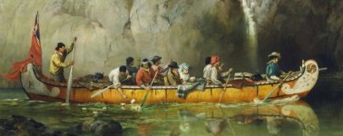
Three of us loaded boat and food and gear onto my 10-month old Ford Econoline van and drove south toward St. Louis. On the roof was a fiberglass replica birchbark canoe that I borrowed from a voyageur canoe racing club I belonged to at that time. The thing is 26 feet long and four feet wide, easily holds eight to ten paddlers. There was going to be just six of us, so there'd be plenty of room for gear. I don't have any pics of the trip or boat, so I'm including an image of a historic 1869 painting of what the craft looks like as a substitute. We didn't dress like that though. No flag either.

1731432729720.jpeg

We northerners got down to my parents' house and slept for a few hours. Up the next morning, my mother decided not to go, so my father and brother loaded his car and we caravanned down so we'd have our own shuttle. We decided to end the trip at Gilbert, Arkansas (population 50?), where there's a paved access point to the river (no bridge crossing) that we could use as a takeout. We got any required gear from my dad's car transferred to the van and his car parked in the lot up near the town. They crawled in with us, and we headed upstream to a launch point. We chose Woolum Ford, which gave us a 22-mile river run, two nights on the river planned, hopefully a short paddle today after launch, a little longer distance on Easter Sunday, and then another short one Monday to the takeout so we could get back to my parents' and then head for home.

Woolum Ford is a low-water bridge across the river. These are basically a line of several large culverts in the river with concrete over them to make a bridge and the water passes underneath through the culverts. When the water level goes up to more than the culverts can handle, the rest goes over the bridge, which acts as sort of a dam, and it can't be driven across. That doesn't happen often or usually for real long.

We unloaded the canoe, which weighs about 250 pounds, not bad for one as big as it is. I pulled out all the paddles and life jackets, and we loaded them and the tents and other gear plus food and kitchen equipment, including a Coleman stove, into the boat. I moved my van from the riverside boat ramp up to the parking lot there and we're ready.

The Buffalo River isn't a real "whitewater" trip, at least not the section we're on, though at low water there are some quite rocky stretches to negotiate, four- to five-feet-a-mile gradient. We're a bit above that, and at a medium water level there are some waves, which wouldn't be of much notice in the large boat we had. The level on the gauge at Gilbert was about seven feet, a somewhat low medium level, no problem for the boat we have or us as paddlers. I've been unable to convert this gauge height to volume (cfs -- cubic feet per second) as daily digital records don't seem to be kept back that far. We launched.

The Buffalo is a nice clear stream as long as it isn't raining, and there hadn't been any precip recently. We were due some, but it shouldn't be more than showers. Remember this is weather forecasting in the early 1970s, before reliable weather satellites were up and sending good data back to Earth.

We paddled downstream slowly, not intending to go far, noticing a nice beach on the right with no one on it maybe five or so miles downstream. This would be a good spot, so we beached the boat and unloaded. We got camp set up while gabbing and getting reacquainted again after months or more apart. We pulled the boat up the beach, which was rather steep, with a good level spot on top for a campsite. We turned the boat over, I threw the paddles and life jackets underneath the boat to get them out of the way, and we set up for cooking supper. Did that, even popped one of those expanding aluminum foil Jiffy Pop popcorn thingies for "dessert." It had been a reasonably warm day, and the night started off that way too.

Partied out and tired from all the travel and excitement, we went to bed shortly after dark. Don't remember the tenting configuration now, but we had at least four of them set up I think.

BOOM!, lightning and thunder shortly after midnight along with a drenching rain, one of those "frog strangler" types that really dumped water on us. It was still sprinkling heavily in the morning but slowed and stopped soon. We learned later that the area got about 4.5 inches in that deluge. At first light, barely enough to be able to see, I unzipped my tent door and I could slap water with my hand without stepping outside. I jumped out in my swimming suit (worn all night) and started shouting for everyone to get up quickly. The water level had to be up maybe six or eight feet already from yesterday after we'd pulled in here.

Others started crawling out of tents and helping. The first thing I did was look for the boat. Yup, still there, but the lower end was bobbing in the water and it could pull free at any time as I hadn't tied it -- we had just pulled it completely out of the water last night. I grabbed it and hauled it up the beach farther. Uh, oh. Paddles and life jackets? I'd thrown them under the boat last night! I looked under it, and no paddles or PFDs. I turned around and glanced downstream. Spinning in the first eddy was our collection of paddles with the life jackets on them. When I'd thrown them (carelessly) under the boat, the paddles had been close together and the PFDs landed on top, holding them all together as a unit. I swam out and got them. (I could mention here that I was two years out of college at that time and had been an NCAA swimmer all four years. No trouble at all, not even dangerous -- my opinion -- swimming out to where they were.) The water was sure muddy and dirty now though. Our tranquil (not really) little stream was now probably past the point of a raging torrent.

We got the tents broken down, pulled poles apart enough without taking them down fully or packing them -- plenty of room in the boat with just five of us -- and then threw the rest of the gear in with them. Our beach was quickly disappearing and we were already on an island, one that was likely to disappear entirely very soon. We had to leave.

We climbed in and pushed off. My sister was feeling terrible, possibly a flu bug or something. She vomited once before we pushed off, and soon she was complaining that hydraulic pressure at the other end was starting to make itself known. We found a place to ground the boat and she did her thing there, both ends. That happened at least one more time. The river wasn't difficult, just really fast current now, rocks way under water, so we decided to keep going rather than stop and wait it out. No telling how long the wait would be. No roads along the river either side to access anywhere.

Ozark streams are often in quite narrow valleys with some side-to-side meandering going on in the valley bottom. However, the river was still rising very rapidly and was soon up high enough that the water didn't always follow those meanders. It spilled over the banks, and the top of the river -- the part canoeists use -- is in places now going straight down the valley in a rush, through the trees and anything else that's there. Anyone camped, and we passed several groups, were all slowly climbing the sides of hills with their gear in order to stay above the water. We had to follow those meanders, meaning lots of ferrying left and right ("setting the bend") to avoid said trees the water pushed us towards. After a couple stops for my sister to empty, and I think just two or three hours after we pushed off, we went under the Route 65 bridge, and Gilbert is just four more miles downstream.

We had to watch for it. There is an access road and boat ramp at the 65 bridge, but though the river was up it was not above our ability, so we kept going toward my dad's car and an easy no-hitch-hike shuttle. The Gilbert boat ramp is usually signaled by a big gravel bar on the left, which was now way under water. It still made a big wide spot that warned of the paved access road down the hill to the boat ramp. I'd taken a look here before we drove upstream so I'd know it for sure when we got here (tomorrow!). That road was also easily visible because there were lots of people standing on it watching the river zoom by as it rose. The crowd was inching backwards up the hill continually to avoid getting their feet wet. We eddied out less than half an hour after going under the Route 65 bridge. We guys immediately started unloading gear. My friend hauled my sister up the steep hill in search of help for her. The town's mayor took her in and put her to bed in her house, while we sorted gear and packed what was still loose, like tents and sleeping bags. It had stopped raining.

My friend came back down. We put her to work watching the boat and gear. We could stand there at that time and watch the river rise an inch a minute on the marked gauge. I timed it for a few minutes. I don't remember what the level was then, though 20s sticks in my mind, but I heard that it later peaked at 49 feet on that gauge, up from the seven feet we saw yesterday. With the friend watching gear and leapfrogging it up the ramp, retying the boat higher up when she could do that, my father, brother, and I took off in his car to go get my van.

Out to Route 65 and head north to the larger town of St. Joe, turn left onto a county road there towards Woolum (no real town that I remember, just a couple farm houses around), but within a mile or two of Route 65 there's a bridge over Mill Creek. That bridge was under water. There's a guy on our side already there, who said he'd made it out from Woolum Ford and crossed this bridge about a half hour ago, just a few minutes before the water made it impassable. No other way to Woolum that wouldn't also have bridge problems. We're on the north side of the Buffalo River. We might be able to get to the south side of the Woolum Ford bridge, but I'd still be staring across the river at my van. We asked him how the river was doing down at Woolum. He told me that when he left, there was one vehicle in the parking lot, a yellow van. At that time the water was about half way up the windows of that van. Mine of course. The parking lot it's in would be a large eddy and not in current, so it's not getting swept away to end up as river litter.

We drove back to Gilbert where we carried the canoe up and parked it in the mayor's yard until I could come and get it, then we loaded what gear we could and all of us back to my parents' house in my dad's car. Tight fit. We ended up putting my friend and sister on a Greyhound bus for Chicago. I called work and explained the situation, that I'd be home a few days late, and stayed there with my parents in hopes of salvaging things. And, yes, tell the paddling club the boat is fine.

I waited a couple days for the water to go down. Even back then, any flooded vehicle is an automatic total. I'd have to buy a new one, but insurance would cover much of it, and that could wait until later. I rented a car for a one-way trip home, one that I could put boat racks on to haul the canoe to Chicago with me. I drove down to Gilbert and picked up the boat, got it tied on the rental car, and headed for Chicago.

I ended up with a beater 1964 Ford Galaxie 500 for interim wheels as another van was built for me.

Many years later we ran across another canoeing couple who was on the river that same weekend, we think a different section though. They had much the same experience but didn't lose a vehicle.

End of story.

I've attached an image above of a painting done back in 1869 by Frances Ann Hopkins, the wife of the secretary to the head of Canadian operations of the Hudson's Bay Company (of England), originally a big fur trading company. Many of you will already know of her. The artist painted herself into the picture, the lady with the blue hat, her heavily bearded husband beside her. The boat we paddled on the Buffalo that year looked exactly like this one. From 50 feet away few would be able to tell it wasn't a boat just like the one in the painting, that good of a replica. Ours was a little shorter as this one pictured is probably closer to 30 feet or maybe a bit longer. Ours was 26 feet. There is a good online Wikipedia article on the painter.

Easter Sunday 1973 was April 22, and the Buffalo hit 79,300 cfs that day according to the instantaneous stream flow data from the USGS for that year. I'm trying to find daily averages for that year but haven't succeeded yet. Trying several different approaches to it indicates to me that the data just isn't available, likely only in paper form, not digital back that far. The highest the Buffalo has been that I can see is 158,000 cfs on December 3, 1982, which is almost twice the Easter '73 peak flow. We didn't paddle on 79K that trip, took out before it got anywhere near that high. It wouldn't surprise me if we weren't floating on 20K or more though, maybe even higher. There have been many other times the Buffalo at that gauge has been over 100Kcfs.
 
Back
Top