Just back from five days touring the Downeast Lakes region. I think of this area as Maine’s mini Boundary Waters. At least 15 lakes can be reached by paddling or short portage — and 20 or more if you are up to longer portages. Yes, there are cottages but, with the exception of bottle lake, the cottages are so few and far apart and the shear size of the lakes so large that it all still feels very remote and wild. I usually get in two or three trips here each year.
On this trip, I launched from the dam at Grand Lake Stream late on Tuesday. It’s not the most remote feeling launch site, but it was late afternoon on Tuesday and I had to paddle the 8.5 mile length of West Grand Lake to get to the night’s campsite at McClellan Cove (45 14.9082, -67 53.0759). Fortunately, there was only a slight head wind and I made good time, arriving just before 7. The heat wave was scheduled to come in the next day, but it was still comfortable on this night and good sleeping weather.
Sorry, I don’t have pictures of this first campsite. Even though I worked as a commercial photographer for 12 years, I find that I take very few personal pictures.
McClellan Cove is a nice site maintained by the Downeast Lakes land Trust. In fact, I took this trip as a volunteer for the DLLT to maintain theis and four other sites assigned to me. That meant pouring lye in the new privy’s that were built last year, sweeping the cobwebs out washing the toilet seats, raking around the fire pits, restocking the the ammo boxes at each site with a DLLT brochure, pencils and a log book. Good work if you can get it.
The McClellan site has two picnic tables, a good fire ring and spectacular views of the lake and surrounding hills. However, it has a very rocky shore and a south wind will make landing difficult if you try to do so at the campsite marker. The best place to land and unload is on a small beach in the corner as you head down the west side of the point. There is a trail that leads back to the campsite. This beach also offers good swimming.
Night two and three were on a small island in the middle of Junior Lake. To get there, you paddle southwest along the far shore of West Grand Lake, turn west into the narrows and cross Junior Bay under Bear Island. Then you head north up the west shore of Junior Bay until you veer left into Junior Stream. The land on the left is part of the Passamaquoddy tribal lands and non-tribal members are asked to not land here out of respect for the tribe’s sovereignty. However, the land on the right on the narrow peninsula is private with a great campsite (45 15.3302, -67 57.4641) on level ground below a cathedral like stand of pine trees. On this trip, I passed by the campsite and continued up Junior Stream.
Junior Stream is an interesting paddle. I usually travel it in the fall and almost every time am entertained by a family of otters playing and feeding. There are beaver, too, and eagles. It looks like moose country but I have never seen one here. I have, however, caught many nice smallmouth bass. In addition to wildlife, Junior Stream also has plenty of rock gardens. This is a very slow moving stream, so this isn’t anything like quick water. However, there are lots sleepers waiting to scratch your boat. I’ve always made it through clean, usually as a matter of luck more than skill. These days, I take along either a pole or a long paddle that I can use standing up to get a better view of what’s ahead of me.

After about 2.5 miles, Junior Stream leads to Junior Lake. Now, just under 2 miles straight ahead and in the smack middle of the lake is an island that doesn’t seem to have a name on any map I’ve referenced. It is the southern most of four small islands that sit just south of Big Islands. Don’t confuse these with the string of islands to the east.
I like to wake early and get my travel done early so I can enjoy time in camp reading or napping or exploring. I was padding by 6:30 on Wednesday morning and arrived at this campsite just about 10. I like to approach the campsite from the west into what I think of as a lagoon (I know it’s not really a lagoon) between it and another island. Once inside this lagoon, there is a sand beach on the left and you can see the ubiquitous yellow “Fire Permit Require” sign just above the beach. I landed here and enjoy one of the finest campsites in all of Maine. It has spectacular views, lots of bird watching, shade when you need it and usually a nice breeze. The breeze was especially important on the day I was there, which hit 92 degrees.

And there’s the not-a-lagoon between the two islands. The water is cool and deep and perfect for walking in. Given its shape, it would actually be near perfect for swimming laps. I’m not a confident enough swimmer to do that when traveling solo, so I just walked in to waist high and sat down to let the water cool me off.
Last year, when I was on this island, the red squirrels were a persistent presence. This year I didn’t see a single squirrel. I’m guessing that they left during the winter and didn’t make it back before ice out. Maybe somebody here has a better explanation.
Anyway, when I woke Thursday morning, I could definitely tell I had not recovered from two days of paddling in the heat and so chose another leisurely day of reading (a book about Carl Jung), chasing the shade and sitting in the water. It reached 90 degrees this day with a little more humidity. Still, there was a stiff breeze which kept things comfortable enough, and just before dark a short rain storm cooled it off enough to use the sleeping bag.
When I arrived, I was greeted by this sculpture left by another visitor:

It’s hard to see in the photo, but there’s a little bench in front of the fire pit. It’s made out of a piece of curled bark. Very clever.
The forecast had promised a northern breeze to carry me back to West Grand Lake. The plan was to paddle to Farm Cove, where there is another DLLT campsite. I would stay there the night and also do my volunteer thing of cleaning the privy, etc. Well, as you know lakes make their own weather. Instead of a tailwind, I had a head wind for the first half and an easterly wind hitting me broadside for the second half. One of the things I’ve come to stop doing this past year is count of wind forecasts. Too many times I’ve passed on my daily canoe paddle because of a forecast of heavy winds only to wake up and find it perfectly still out. Now I go to the launch before assuming anything.
At least it was a cooler day at 88 degrees. I reached the Farm Cove campsite (45 13.3830, -67 52.6887) about noon and set out to do my DLLT chores, including cleaning the privy.

Here’s are two better views from the campsite.


After a restful night, I woke early with the intention of being on the water by 6:30 to get to the campsite at Little Mayberry Cove (45 12.2475, -67 48.7160). This is site is just 3 or so miles from the launch at Grand Lake Stream and a good destination if you arrive late. there’s not much special about it but it’s convenient and surround by lots of firewood. After doing my DLLT chores, I headed out, stopping for breakfast at the Pine Tree Store. This is a must stop and I encourage all who canoe here to stop in, enjoy the store’s charm and at least buy a coffee. The store is an important asset to the community and welcomes all visitors to the area.
If I were to do this trip in July and August, when there are more visitors and more motorboats on West Grand Lake, I would drive the 10 plus miles of dirt road to launch at Dobsis Dam. There are beautiful drive-in campsites right at this remote dam for late arrivals, and the access to paddling here includes all the West Grand/Junior Lake/Scraggly Lake corridor on one side and the Sysladobsis Lake/Third and Fourth Machias on the other side. Like I said, it’s a mini Boundary Waters right here in Maine.
Hope this was worth your time to read. If this inspires you to canoe here, let me recommend the fall. It really buttons up there after Labor Day and I have gone on six day trips without seeing another boat or person. It really is quite a feeling to be the only person on these large lakes. Anyway, hope you enjoyed the write up.
On this trip, I launched from the dam at Grand Lake Stream late on Tuesday. It’s not the most remote feeling launch site, but it was late afternoon on Tuesday and I had to paddle the 8.5 mile length of West Grand Lake to get to the night’s campsite at McClellan Cove (45 14.9082, -67 53.0759). Fortunately, there was only a slight head wind and I made good time, arriving just before 7. The heat wave was scheduled to come in the next day, but it was still comfortable on this night and good sleeping weather.
Sorry, I don’t have pictures of this first campsite. Even though I worked as a commercial photographer for 12 years, I find that I take very few personal pictures.
McClellan Cove is a nice site maintained by the Downeast Lakes land Trust. In fact, I took this trip as a volunteer for the DLLT to maintain theis and four other sites assigned to me. That meant pouring lye in the new privy’s that were built last year, sweeping the cobwebs out washing the toilet seats, raking around the fire pits, restocking the the ammo boxes at each site with a DLLT brochure, pencils and a log book. Good work if you can get it.
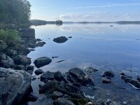
The McClellan site has two picnic tables, a good fire ring and spectacular views of the lake and surrounding hills. However, it has a very rocky shore and a south wind will make landing difficult if you try to do so at the campsite marker. The best place to land and unload is on a small beach in the corner as you head down the west side of the point. There is a trail that leads back to the campsite. This beach also offers good swimming.
Night two and three were on a small island in the middle of Junior Lake. To get there, you paddle southwest along the far shore of West Grand Lake, turn west into the narrows and cross Junior Bay under Bear Island. Then you head north up the west shore of Junior Bay until you veer left into Junior Stream. The land on the left is part of the Passamaquoddy tribal lands and non-tribal members are asked to not land here out of respect for the tribe’s sovereignty. However, the land on the right on the narrow peninsula is private with a great campsite (45 15.3302, -67 57.4641) on level ground below a cathedral like stand of pine trees. On this trip, I passed by the campsite and continued up Junior Stream.
Junior Stream is an interesting paddle. I usually travel it in the fall and almost every time am entertained by a family of otters playing and feeding. There are beaver, too, and eagles. It looks like moose country but I have never seen one here. I have, however, caught many nice smallmouth bass. In addition to wildlife, Junior Stream also has plenty of rock gardens. This is a very slow moving stream, so this isn’t anything like quick water. However, there are lots sleepers waiting to scratch your boat. I’ve always made it through clean, usually as a matter of luck more than skill. These days, I take along either a pole or a long paddle that I can use standing up to get a better view of what’s ahead of me.
After about 2.5 miles, Junior Stream leads to Junior Lake. Now, just under 2 miles straight ahead and in the smack middle of the lake is an island that doesn’t seem to have a name on any map I’ve referenced. It is the southern most of four small islands that sit just south of Big Islands. Don’t confuse these with the string of islands to the east.
I like to wake early and get my travel done early so I can enjoy time in camp reading or napping or exploring. I was padding by 6:30 on Wednesday morning and arrived at this campsite just about 10. I like to approach the campsite from the west into what I think of as a lagoon (I know it’s not really a lagoon) between it and another island. Once inside this lagoon, there is a sand beach on the left and you can see the ubiquitous yellow “Fire Permit Require” sign just above the beach. I landed here and enjoy one of the finest campsites in all of Maine. It has spectacular views, lots of bird watching, shade when you need it and usually a nice breeze. The breeze was especially important on the day I was there, which hit 92 degrees.
And there’s the not-a-lagoon between the two islands. The water is cool and deep and perfect for walking in. Given its shape, it would actually be near perfect for swimming laps. I’m not a confident enough swimmer to do that when traveling solo, so I just walked in to waist high and sat down to let the water cool me off.
Last year, when I was on this island, the red squirrels were a persistent presence. This year I didn’t see a single squirrel. I’m guessing that they left during the winter and didn’t make it back before ice out. Maybe somebody here has a better explanation.
Anyway, when I woke Thursday morning, I could definitely tell I had not recovered from two days of paddling in the heat and so chose another leisurely day of reading (a book about Carl Jung), chasing the shade and sitting in the water. It reached 90 degrees this day with a little more humidity. Still, there was a stiff breeze which kept things comfortable enough, and just before dark a short rain storm cooled it off enough to use the sleeping bag.
When I arrived, I was greeted by this sculpture left by another visitor:
It’s hard to see in the photo, but there’s a little bench in front of the fire pit. It’s made out of a piece of curled bark. Very clever.
The forecast had promised a northern breeze to carry me back to West Grand Lake. The plan was to paddle to Farm Cove, where there is another DLLT campsite. I would stay there the night and also do my volunteer thing of cleaning the privy, etc. Well, as you know lakes make their own weather. Instead of a tailwind, I had a head wind for the first half and an easterly wind hitting me broadside for the second half. One of the things I’ve come to stop doing this past year is count of wind forecasts. Too many times I’ve passed on my daily canoe paddle because of a forecast of heavy winds only to wake up and find it perfectly still out. Now I go to the launch before assuming anything.
At least it was a cooler day at 88 degrees. I reached the Farm Cove campsite (45 13.3830, -67 52.6887) about noon and set out to do my DLLT chores, including cleaning the privy.
Here’s are two better views from the campsite.
After a restful night, I woke early with the intention of being on the water by 6:30 to get to the campsite at Little Mayberry Cove (45 12.2475, -67 48.7160). This is site is just 3 or so miles from the launch at Grand Lake Stream and a good destination if you arrive late. there’s not much special about it but it’s convenient and surround by lots of firewood. After doing my DLLT chores, I headed out, stopping for breakfast at the Pine Tree Store. This is a must stop and I encourage all who canoe here to stop in, enjoy the store’s charm and at least buy a coffee. The store is an important asset to the community and welcomes all visitors to the area.
If I were to do this trip in July and August, when there are more visitors and more motorboats on West Grand Lake, I would drive the 10 plus miles of dirt road to launch at Dobsis Dam. There are beautiful drive-in campsites right at this remote dam for late arrivals, and the access to paddling here includes all the West Grand/Junior Lake/Scraggly Lake corridor on one side and the Sysladobsis Lake/Third and Fourth Machias on the other side. Like I said, it’s a mini Boundary Waters right here in Maine.
Hope this was worth your time to read. If this inspires you to canoe here, let me recommend the fall. It really buttons up there after Labor Day and I have gone on six day trips without seeing another boat or person. It really is quite a feeling to be the only person on these large lakes. Anyway, hope you enjoyed the write up.