- Joined
- Mar 16, 2017
- Messages
- 256
- Reaction score
- 209
About 20 years ago, Doug Doremus mailed me a newspaper article from Lubec Maine. In it Mike Krepner talked about his dream of forming a canoe trail he would call the Northern Forest Canoe Trail. I found a way to contact Mike and me & Doug considered following the route he and three others had concocted. But 750 odd miles was too long for us, so we opted to make our own route and starting in 2000 we paddled from the Saint Lawrence Seaway to Casco Bay in three separate trips over the course of 15 years. As we were deciding on a route, I caught up with Mike in his yert at the Maine Festival of the Arts at Thomas Point Beach. He lamented that he was mostly able to sell only cell phone bags and Delorme Atlas cases to the yuppies. I bought a Skitikuk Portage pack made in his solar shop in Waldoborough. We sat and talked for quite a while. Mike helped in the planning of that trip, suggesting two different routes from the Saint Lawrence and so much info on other portage and travel routes.
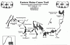
Before the NFCT, Mike created the Eastern Maine Canoe Trail, which never really caught on, and he also drew simple black and white maps of several other ancient canoe routes in Maine. Some people collect mountain peaks, like the NE 4,000 footers. I collect Mike's portage trails.The Maliseet Trail, the Gassabius Portage, Winnegance and the Pemaquid Portage to name a few.
This weekend, on Saturday, a friend and I are going to cover the Merriconeag Portage, which requires landowner permission and the highest of high tides, pass by Thomas Point Beach on our way north up the New Meadow River to Che'aguahadongonek (Also known as Stevens Carry) which crosses over to the Androscoggin as it enters Merrymeeting Bay. These are just two of the fifteen or so coastal carry trails that make up Mike's Wawenok Ahwangans. In honor of Mike Krepner, I'll dust off that old Skitikuk Pack and use it for this trip, and toast his memory on the trail.
His old website, NativeTrails.org, disappeared a long time ago. If you do a web search for Igas Isle, his outfitting company, you get no results. It's as if he took a look at today's technology, turned, and with one last look over his shoulder, disappeared into the bush. Rest in peace, Mike.

