• Happy Apple Cider Day! 🍎🍵

River Advice for Virginia or thereabouts

Joined
Apr 17, 2023
Messages
181
Reaction score
283
Location
Nantucket, USA
I go on a canoe trip with a reasonably experienced group of men every year (we average about ten people in five tandem boats) and the mantle of trip-leader gets passed around between a smaller contingent. This year, a friend from Richmond, Virginia is organizing the trip and thinks he might plan something in his neck of the woods. He hasn't selected a river and I'm hoping this community might help point us in the right direction. I bought a copy of Roger Corbett's "Virginia Whitewater" but I'm curious if there are any rivers particularly suited to our profile.

Normally our trips are in Maine: both branches of the Penobscot, Webster Brook, Allagash, Machias, St. Croix, etc. The trips average 5-6 days and every year we rent the majority of our boats and coordinate a shuttle trip with a local outfitter. We enjoy whitewater up to class III and prefer remote-feeling locations. We used to saddle ourselves with big mileage but have mellowed. Limited portages are ok but this is not exactly a fast and light group.

Thank you, Steve
 
The New River is a good bet. It runs from NC through VA to WV. It is big and historic. Below Hinton it is a large, wide, powerful river. It is awesome for solid paddlers but a lousy place to have a yard sale.

WV has many gems suitable for multiday trips including the Greenbrier and Cheat.

Few of these rivers are pure wilderness, but there are lots of isolated runs along the trip.

There are also low country options, like the rivers feeding into the Albemarle sound. No whitewater, but some open water. Perhaps someone else can recommend a specific one of those.
 
Virginia in July/August is gonna be very hot and humid if you're used to Maine summers.
The Upper James is a good sixty-mile run, but it is not remote. The river parallels train tracks and roads for most of it, and some camping spots are frequented by car campers fishing. In July it'd be pretty bony in spots. It's mostly private land on both banks; there are a few islands to camp and some National Forest land, but generally you'll pay for campsites, so check those prices. There are a goodly number of riffles, a few good 2s in normal water levels, and a miles-long rock garden between Glasgow and the final takeout.
Two Rivers outfitters in Buchanan would be the people to call first; they run campgrounds and rent boats. Shoot me your email in a PM and I'll send you some maps.
 
crap, wait... with McCracken's closed, shuttle/canoe rental is problematic (and water level is sketchy in August anyway)... Allegheny river from Warren, PA to Emlenton or Parker? Might only be 5 days but there are good shuttle/rental options.
 
I go on a canoe trip with a reasonably experienced group of men every year (we average about ten people in five tandem boats) and the mantle of trip-leader gets passed around between a smaller contingent. This year, a friend from Richmond, Virginia is organizing the trip and thinks he might plan something in his neck of the woods. He hasn't selected a river and I'm hoping this community might help point us in the right direction. I bought a copy of Roger Corbett's "Virginia Whitewater" but I'm curious if there are any rivers particularly suited to our profile.

Normally our trips are in Maine: both branches of the Penobscot, Webster Brook, Allagash, Machias, St. Croix, etc. The trips average 5-6 days and every year we rent the majority of our boats and coordinate a shuttle trip with a local outfitter. We enjoy whitewater up to class III and prefer remote-feeling locations. We used to saddle ourselves with big mileage but have mellowed. Limited portages are ok but this is not exactly a fast and light group.

Thank you, Steve
For some reason, respondents think you want to go in July/Aug. If true, water levels could become an issue.

My first thought is the James. Andy Lee published a TR on his trip down the entire James. Maybe even on the old p-net, so it could be here somewhere. IIRC, he had to do a lot of commando camping. On the upper James, I've camped on gravel bars, but I think camping becomes increasingly scarce as you move down river. With a group of ten, it might be tough You could do a lot of good day trips, but I think you'd have to base camp somewhere off river. So, maybe not the James.

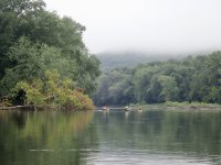
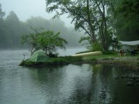
Photo: Camped on a gravel bar, upper James River. Sept. 2008.
IMGP0092.jpeg

I have a total of one day trip on the New, so I don't have much to say on that. I'd be surprised if there are good, multi-day trips there, but, I'm pretty ignorant about the New.

The Potomac is an ideal candidate. There is always water. The C&O canal, administered by NPS, runs 180 miles on the Maryland side from Cumberland to DC, so at least one side of the river is undeveloped, and there's not much on the Virginia side for long stretches. On the canal, there are hiker-biker camp sites about every 10 miles, though from the river the access paths may be steep and narrow. At least there are sites. At summer levels there are islands and gravel bars that also make good sites. It's mostly swiftwater or flat water but there are rapids, including Class V Great Falls, which often can be paddled around via the rewatered C&O. Also, short portages around several dams, from the river to the canal above Great Falls, and around locks on the canal. I think Corbett describes a lot of this stretch, but you can start further upriver than Corbett describes. For example, Old Town to Little Orleans is a favorite stretch.

Photo: Potomac between Old Town and Little Orleans. Aug 2019
P7310022.jpeg
 
I think Chip is right about this
IIRC, he had to do a lot of commando camping. On the upper James, I've camped on gravel bars, but I think camping becomes increasingly scarce as you move down river. With a group of ten, it might be tough

Almost all the 3+ day trips I'd consider in the Mid-Atlantic states will require careful planning. Including reservations at national, state, private campgrounds or houses.
 
Interesting thread. I'm trying to work out a trip in the Mid Atlantic states with my old partner. I'm on Long Island, he's in NC.
I was originally thinking of using my canoes or kayak. I have a light 15'x28" double paddle solo, a cedar 15'x35" tandem, and a Folbot Yukon. I thought I would bring the tandem and the Yukon. We would test the tandem, if it was overloaded we could assemble the Folbot and use both. Now I'm thinking that renting might be simpler if we can.
 
The more I think about it, rental, shuttle, etc taken into account, I think I'd stick with the Allegheny if you head this way. Water levels are more stable as the upstream dams need to maintain adequate water for the barge traffic downstream and most of the islands are public and open for camping (there are also shore camps; especially as you get further south).

Total length is about 110 miles and flow is around 2 or 3 mph so you could paddle a little, float & fish a lot (good smallmouth & walleye/ sauger fishing) and takeout at Emlenton or Parker for a 4-5 day trip (or paddle fewer hours and take even more time). I know of at least 1 outfitter who does full outfitting (PM me if you like & I'll send his contact info) and he could also provide up to date info. If you want to look into it, here are two links to get you started... Trail info & a river map.

Bonus: No portages. Downsides: No whitewater either. Upper stretches are reasonably rustic but there are signs of human habitation throughout the trip.

Whatever you decide, Steve ("Psue"?), let us know. We need more info on options in the east so let us know what you find.
 
Wow, this is all great insight. Thank you! I can confirm that we're indifferent as to the timing of the trip and we would adjust based on weather and water levels, depending on the final river selection.

Since my original post, our trip leader indicated that he had already been looking at West Virginia, so MrPoling's post is right on target.
WV has many gems suitable for multiday trips including the Greenbrier and Cheat.
At first blush, the Greenbrier River seems a little more suited to our open and heavily loaded rental canoes, since there are fewer III+ rapids. Based on my quick internet search, here is the best Greenbrier river paddling description I've found so far. Only 3.5 hours from Richmond, this seems very promising and there's also something to be said for the possibility of a little end-of-trip revelry at the Greenbrier Resort too. Early research indicates that maybe April or May would be the best time to run the river?

I'll start digging into this a little bit further to verify adequate river-access campsites to support a multi-day trip and report back.
 
Last edited:
In the hopes of keeping this thread useful for others like @JohnSand, I'm going to summarize the info provided above. As a general note for this area, and per @MrPoling "Almost all the 3+ day trips I'd consider in the Mid-Atlantic states will require careful planning. Including reservations at national, state, private campgrounds or houses."
  • Virginia
    • James River - Per @MyKneesHurt: not remote. Few good riffles and class II, miles-long rock garden between Glasgow and the final takeout. River parallels train tracks and roads, some camping spots are frequented by car campers . Bony in July. It's mostly private land on both banks; there are a few islands to camp and some National Forest land, but generally you'll pay for campsites, so check those prices. Two Rivers outfitters in Buchanan run campgrounds and rent boats. Per @Chip : camping becomes increasingly scarce as you move down river.
    • New River - per @MrPoling "Runs from NC through VA to WV. It is big and historic. Below Hinton it is a large, wide, powerful river. It is awesome for solid paddlers but a lousy place to have a yard sale."
    • Potomac - Per @Chip: Always water. The C&O canal, administered by NPS, runs 180 miles on the Maryland side from Cumberland to DC, so at least one side of the river is undeveloped, and there's not much on the Virginia side for long stretches. On the canal, there are hiker-biker camp sites about every 10 miles, though from the river the access paths may be steep and narrow. At least there are sites. At summer levels there are islands and gravel bars that also make good sites. It's mostly swiftwater or flat water but there are rapids, including Class V Great Falls, which often can be paddled around via the rewatered C&O. Also, short portages around several dams, from the river to the canal above Great Falls, and around locks on the canal. I think Corbett describes a lot of this stretch, but you can start further upriver than Corbett describes. For example, Old Town to Little Orleans is a favorite stretch.
  • West Virginia:
  • North Carolina: Low Country Rivers that feed into Albemarle Sound (Blackwater, Nottway, Meherin, Roanoke) - no whitewater
  • Pennsylvania
    • Allegheny - Per @Gamma1214 "Water levels are stable as the upstream dams need to maintain adequate water for the barge traffic downstream and most of the islands are public and open for camping (there are also shore camps; especially as you get further south). Total length is about 110 miles and flow is around 2 or 3 mph so you could paddle a little, float & fish a lot (good smallmouth & walleye/ sauger fishing) and takeout at Emlenton or Parker for a 4-5 day trip (or paddle fewer hours and take even more time). I know of at least 1 outfitter who does full outfitting (PM me if you like & I'll send his contact info) and he could also provide up to date info. If you want to look into it, here are two links to get you started... Trail info & a river map. Bonus: No portages. Downsides: No whitewater either. Upper stretches are reasonably rustic but there are signs of human habitation throughout the trip.
    • West Branch of the Susquehanna -
 
Back
Top