A post in a thread several days back made me think of an image or two in this slide sequence one of the other participants took of my wife and I on the Rogue River in Southwest Oregon years back (Late June, 2006), one of the few runs on that river that we paddled together OC2. I no longer remember the thread or which post brought up the memory, so I'll just start another thread and see if anyone else wants to add their own "OOPS" moments to it. It may have been on tying bags in for whitewater vs flatwater, but no longer sure. Could have been a tangent in a thread. Anyway . . .
This river section is the standard "wilderness run" on the Wild and Scenic stretch from Graves Creek to Foster Bar, which I've mentioned in other posts here. This run pictured is of the fish ladder "sneak route" around Rainie Falls, which is reached the first day of this run, being as it's only about a mile and a half or two below the put-in. Rainie Falls is normally about a 6-foot or more drop on the left side and usually into a big hole at the bottom. Height and intensity vary with water level. There's the "middle chute" to the right of the falls itself, a little less intense than the main falls, but very narrow, especially for rafts. The fish ladder way over on river right was blasted by a pioneering river runner back in the early 1900s to make the river navigable for his guided fishing trips. He also dynamited parts of Blossom Bar Rapids downstream and likely at least a few other drops between.
There are nine images here, and I'll just post them all, though some of the early ones are probably a bit redundant and not needed. The photographer is standing on river right down at the bottom of the narrow run. The opposite bank seen in the pics here is actually an island and "middle chute" and the main falls runs are on the other side of the island, obscured in thse images. Sorry, I can't find a pic of either of them. You can find YouTube vids online of many runs of all three of these routes if interested.
Here are the first three shots in the sequence. The run looks narrow and rocky and it is up top. I thought we were at a higher than normal water level, like 6,000 cfs or higher, but the historical reading of the Agness gauge near the takeout indicates it was between 3600 and 3700 CFS during our run. It can get below 2,000 CFS in the late summer before the winter rains kick in, and has been really high at times in the past. For instance, the gauge hit 129,000 CFS in December, 6 months before our run, and in December 1964, a huge storm that hit much of the West Coast sent the guage up to 290,000 CFS. Really high! My own flow estimation firmware between the ears is rusty these days, but thinks you're looking at maybe 250-300 CFS maximum in the channel here. Anyway:
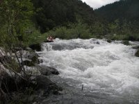
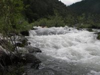
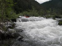
Okay, to there it was just rock picking on the way down, and I was trying to get even farther left than I was. Looks like I'm way left in this next image, but I'm not as far over as I want to be, as here it starts to get a bit dicey.
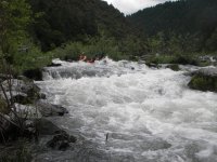
This next pic below is where my wife is starting to wonder about the wisdom of agreeing to the run of this drop. Hey, babe, there's worse downstream! She actually knows that, as she's been on the run before in rafts several times. I have usually paddled this run OC1.
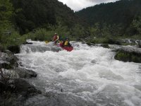
This next pic is where she is figuring out she might not want to be here.
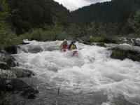
Our boat here, reasonably heavily loaded with gear already, is now at least half full of water. Notice that the sternman (yours truly) is ready to slap a good low brace. I really wish we were a bit left more as we'd have missed most of the hole(s).
This next image is priceless!
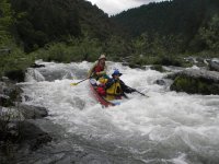
You'll notice above that she really doesn't want to be here now. But the lumps are almost over, mostly just a fast short bouncy runout from here, which is good as we're essentially full of water.
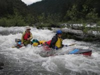
It doesn't look like the end of the action in the above or next image, but it is smooth right after this one, though I don't have a pic of it.
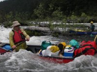
Just bouncy, and smooth water after this one. My end of the canoe doesn't look full, but we did fill it the rest of the way here in these little waves as our freeboard is next to nothing now. The gunnels amidships were under the water soon after this. We paddled the boat to shore (all of 6 feet away?), so close that the photographer couldn't get the whole boat into the frame for the above picture. Just dumped it out and ready to go again.
The boat is a Royalex Dagger Legend 17, a real pig (not only my opinion). We borrowed it for the run to just try it out and hated it. Heavy and real wet in our opinion. We wished we'd have brought the Venture 17 instead (also a Royalex Dagger), but we didn't. We never did flip the boat on the whole run, but were quite lucky in a couple of spots.
That was an "almost oopsie" moment for us. We came through with our upper bodies dry, but not lower bodies. We have gear tied down into the boat, not all of it tight to the floor. There are also air bags in the ends. We don't travel light. We consider trips like this a vacation, not a lesson in deprivation.
Anyone got oops moments of their own to add to this thread?
This river section is the standard "wilderness run" on the Wild and Scenic stretch from Graves Creek to Foster Bar, which I've mentioned in other posts here. This run pictured is of the fish ladder "sneak route" around Rainie Falls, which is reached the first day of this run, being as it's only about a mile and a half or two below the put-in. Rainie Falls is normally about a 6-foot or more drop on the left side and usually into a big hole at the bottom. Height and intensity vary with water level. There's the "middle chute" to the right of the falls itself, a little less intense than the main falls, but very narrow, especially for rafts. The fish ladder way over on river right was blasted by a pioneering river runner back in the early 1900s to make the river navigable for his guided fishing trips. He also dynamited parts of Blossom Bar Rapids downstream and likely at least a few other drops between.
There are nine images here, and I'll just post them all, though some of the early ones are probably a bit redundant and not needed. The photographer is standing on river right down at the bottom of the narrow run. The opposite bank seen in the pics here is actually an island and "middle chute" and the main falls runs are on the other side of the island, obscured in thse images. Sorry, I can't find a pic of either of them. You can find YouTube vids online of many runs of all three of these routes if interested.
Here are the first three shots in the sequence. The run looks narrow and rocky and it is up top. I thought we were at a higher than normal water level, like 6,000 cfs or higher, but the historical reading of the Agness gauge near the takeout indicates it was between 3600 and 3700 CFS during our run. It can get below 2,000 CFS in the late summer before the winter rains kick in, and has been really high at times in the past. For instance, the gauge hit 129,000 CFS in December, 6 months before our run, and in December 1964, a huge storm that hit much of the West Coast sent the guage up to 290,000 CFS. Really high! My own flow estimation firmware between the ears is rusty these days, but thinks you're looking at maybe 250-300 CFS maximum in the channel here. Anyway:


Okay, to there it was just rock picking on the way down, and I was trying to get even farther left than I was. Looks like I'm way left in this next image, but I'm not as far over as I want to be, as here it starts to get a bit dicey.

This next pic below is where my wife is starting to wonder about the wisdom of agreeing to the run of this drop. Hey, babe, there's worse downstream! She actually knows that, as she's been on the run before in rafts several times. I have usually paddled this run OC1.

This next pic is where she is figuring out she might not want to be here.

Our boat here, reasonably heavily loaded with gear already, is now at least half full of water. Notice that the sternman (yours truly) is ready to slap a good low brace. I really wish we were a bit left more as we'd have missed most of the hole(s).
This next image is priceless!

You'll notice above that she really doesn't want to be here now. But the lumps are almost over, mostly just a fast short bouncy runout from here, which is good as we're essentially full of water.

It doesn't look like the end of the action in the above or next image, but it is smooth right after this one, though I don't have a pic of it.

Just bouncy, and smooth water after this one. My end of the canoe doesn't look full, but we did fill it the rest of the way here in these little waves as our freeboard is next to nothing now. The gunnels amidships were under the water soon after this. We paddled the boat to shore (all of 6 feet away?), so close that the photographer couldn't get the whole boat into the frame for the above picture. Just dumped it out and ready to go again.
The boat is a Royalex Dagger Legend 17, a real pig (not only my opinion). We borrowed it for the run to just try it out and hated it. Heavy and real wet in our opinion. We wished we'd have brought the Venture 17 instead (also a Royalex Dagger), but we didn't. We never did flip the boat on the whole run, but were quite lucky in a couple of spots.
That was an "almost oopsie" moment for us. We came through with our upper bodies dry, but not lower bodies. We have gear tied down into the boat, not all of it tight to the floor. There are also air bags in the ends. We don't travel light. We consider trips like this a vacation, not a lesson in deprivation.
Anyone got oops moments of their own to add to this thread?
