• Happy Debut of "I Love Lucy" (1951)! 📺👁💘⚽

How accurate do you find Paddle Planner?

Joined
Aug 10, 2018
Messages
1,283
Reaction score
1,681
Location
Blairsville, PA (about 30 mi E of PGH)
I used Paddle Planner to help with my first BWCA trip but mostly for campsite reviews, portage descriptions and pictures so I'd have a little better idea of what to expect. I wasn't a subscriber then so I couldn't build routes or save them. It would show approximate travel time between 2 locations with estimated paddling time and portaging times but, having little experience back then, I didn't pay much attention to those estimates.

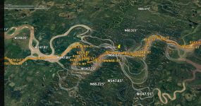
Now, planning a Wabakimi trip next summer, I've subscribed so I can build & save routes but I'm not sure how accurate the app is. I believe that the route I'm considering can be done in 3 weeks but Paddle Planner puts it at 13 days! (I even set it so it would take 3 days to go from the rail line to Savant lake and the more heavily traveled areas).

I input my BWCA route from 3 years ago and checked the time stamps on the photos to compare estimated vs actual paddling times and I seemed to move slowly; typically reaching my destination in about 1/2 again PP's estimated time.

I think I've gotten more efficient at portaging so I'm leaning toward trying the route as planned but allowing for 3 weeks instead of their estimated two (I know some of the portages will be tough and there's always weather delays) but has anyone else compared Paddle Planner's estimates to actual trip time? I've noticed that, when I hit the 3rd week, the planner switched from double portaging to triple (which I won't need to do) but it's still saying 13 days!

Doesn't seem reasonable to me but your thoughts are appreciated.
 
I find it very accurate for distance, campsites, portages,etc. but not so much on time. You can change how fast you paddle and whether you single or double portage but I think it still assumes you never stop paddling.
 
...I think it still assumes you never stop paddling.
Valid point. I DO tend to put down the paddle in favor of the camera and step ashore frequently to check out anything interesting. The times being estimated assuming "constant paddling" might make more sense.

I also don't plan my routes or stick to them if I do, making next days plans each evening.
That's what I'm planning on doing as well but I appreciate that you've also reverse engineered some trips to double-check the times.

Thanks for the input; I'll likely stick with the route as planned and roll the dice on time. The route has options for shortening it if I get into a crunch.
 
I know nothing of commercial trip planner. I do my own route planning. So I went old school and made my own process. For the Yukon River Canoe races, I use Google Earth as relatively accurate, within a couple of years, since the river tends to change its exact route to some extent every year after ice breakup. We passed a number of cliff banks where chunks of earth and permafrost was actively falling into the water, depositing new gravel bars and the current route was notably different than the year before when we were paddling in or near that exact same location.

So initially, using best known historical paddleboat routes around bends, islands and permanent shoals, I plotted my first route map with almost 800 waypoints for the 1000 mile route. I modified the route each year to update it for improvements to the route and speed after we had run the race, or by using the published SPOT route of the latest year fastest racers. Then I downloaded my plotted waypoints into an Excel spreadsheet to do the direction and distance waypoint to waypoint calculations. I included a number of optional cutoff shortcuts out of the main route channel, with on location decisions to be made, depending on water level and current conditions at the time.

A baseline expected current and paddling speed calculated accurate arrival times at each waypoint, very useful for my pit crew to meet or to observe us pass by. My pit crew can load our current SPOT location and time into the spreadsheet and it will dynamically update all future point predicted arrival times based on the day's actual speed and progress so far due to crew paddle apeed and actual river current speed. Each point was labeled with its calculated distance (in tenths of a mile) from the start point, left/right turn next (LT or RT) along with any optional point name. All were then loaded them into my GPS and reloaded back into Google Earth to plot and print the visible route on nearly 100 computer pages, each covering approximate ten mile segments to be waterproofed and put in individual protective plastic sleeves in a 3 ring binder that would go with me during the race. Improvements and updates were made to the route in each of the five years I raced the Yukon (so far). Accurate to actual GPS measured distances within a very small error percentage and invaluable.


Yukon route clip.jpg

circle Y1K route.jpg
 

Attachments

  • Yukon route clip.png
    Yukon route clip.png
    1.1 MB · Views: 2
Last edited:
The times being estimated assuming "constant paddling" might make more sense.
I tend to think of the paddle speed as an average speed. It's also sort of an approximation. I'd never rely on any paddle planning to be someplace at 3:35 on the dot. It's more knowing I'll usually be on the water by 8:00 and want to make camp by 2:00 or 3:00 but so what if Im early or late?
 
So I went old school and made my own process.
It's more knowing I'll usually be on the water by 8:00 and want to make camp by 2:00 or 3:00 but so what if I'm early or late?
Sounds like yknpdlr's method is scary accurate but, for my needs, it doesn't have to THAT accurate. With 2 weeks vacation and taking the 3rd week unpaid, I'm just more concerned with where I might be at the end of the 3rd week than at 3 o'clock on any given afternoon. :D

I'll probably move slow & steady throughout the daylight hours as I'm not really one to lay around camp (didn't even open my book last trip).

I've continued playing with it, I've mapped out a few alternate endings and I'll have with me all the maps the route may traverse. I think it will be interesting to compare their estimated vs my actual times after I'm back.
 
I used it for campsite reviews. I found it was not up to date for conditions and closures in WCPP. The landings need to be emphasized more in their ratings. A 5 star without a beach for bathing, a good landing area, is not a 5 star. It’s useful, but I’m not a subscriber and it’s not my only source for information about a route.
 
It interesting what attributes of a camp site are valued and which not. I'm a wet footer and don't mind getting out in knee deep water April to November, so rarely look at landings. I do highly value level tent pads however. I realize and accept others have different priorities. People who dry foot and hammock would not appreciate my camp site ratings.

I generally aim for sites in BWCAW and the Q based on there orientation to sun and wind. (As a wet footer, you need to dry things. :) )
 
A dear late friend of mine who shared with me 30 years as instructors of BSA guide trek leader training, we often bantered together about strange and humorous training scenarios. When I would discuss with the students about how to wet foot properly and safely load and get in and out of their canoes, he liked to ask me in front of the class to demonstrate so on a rocky deep water high wind shore with my expensive solo carbon canoe. Thanks buddy. One very useful thing he turn me on to many years ago was hammock camping insead of tenting. No need any longer to find a flat level spot on the ground. Slopes, rocks, wet swamps, brushy or dead tree branch debris covered ground, is never a problem.
 
Last edited:
I used it for campsite reviews. I found it was not up to date for conditions and closures in WCPP.
I can see that. It seems that nearly every campsite & portage is reviewed in the BWCA and pictures abound but, looking at maps of most other parks, there is very little to go on.

I think this is largely due to the amount of traffic the BWCA gets and the fact that PP's information seems to be primarily dependent upon the willingness of users to upload reviews, pictures, etc. They incentivize those efforts by offering discounts & on-site "atta boy" awards but accurate, up-to-date information requires a large number of users who are willing to post their experiences after returning home.

Once you venture outside the BW and into areas like Wabakimi, the Everglades or Apostle Islands, you find some campsites marked but almost nothing reviewed or photographed.

I'm still hopeful that it's useful for route planning, it's fun to play with regardless and I DO like that it calculates mileage (kilometerage?) and suggests what maps I'll need.
 
Last edited:
With 2 weeks vacation and taking the 3rd week unpaid, I'm just more concerned with where I might be at the end of the 3rd week than at 3 o'clock on any given afternoon.

I have a pretty good idea of my average daily mileage based on previous trips. I use google maps to roughly measure the mileage of my route and portages. I then divide the total mileage by my daily average to come up with how many days it should take to complete it. Of course you need to fudge for rest/weather days.

Alan
 
Back
Top