G
Guest
Guest
Lance, I’m going to answer your questions under a separate thread, for future Hammocks Beach reference. Hammocks is one of my favorite easy & awesome off-season barrier island paddle-in venues, and I encourage paddlers within striking distance, or travelling through proximity, to visit, especially if unfamiliar with the beauty and novelty of barrier island canoe camping.
Oceanside, it’s not just for kayaks anymore.
Try this link. Go to the right margin and click on Campground Map, and Paddle Trails Map
https://www.ncparks.gov/hammocks-beach-state-park/home
By shallow at low tide I mean that the inlet to the beachfront sites may require wading the boats
 IMG010 by Mike McCrea, on Flickr
That drag was up the inlet en route to the beachfront sites. Sites 12, 13 and 14 are before, or at least a short drag alongside the inlet shallows on the way in. The large open basin past the inlet narrows towards the beachfront sites is usually deep enough to paddle across.
Still, I’d time the tides to paddle out (and back in) for near high tide, so there is paddle blade depth of water in the marsh. Obviously slack to falling tide on the way out helps, and vice versa on the way back. Not that critical for tidal depth along the marked trail through the marsh, but more water, moving in the right direction, is better. Tides done right much the trail is an assisted ride.
Whadda ya want, an extensive, photo heavy travelogue? Happy to oblige, I think Hammocks Beach is another NC State Park off-season gem, on par with Merchants Millpond, but very different from that scenic cypress swamp paddle-in camper
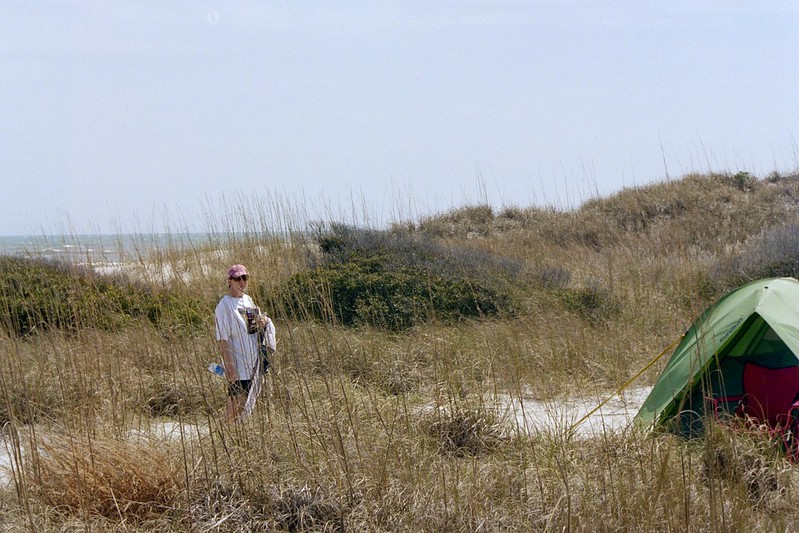
Site 14 is back in the trees, and is my least favorite site. It is sometimes too shady and damp feeling, but it has room for multiple tents, tarps and larger parties.
 P3172667 by Mike McCrea, on Flickr
Site 13 is, uh, interesting in a unique way. A split level site; a dozen steps away from the site landing is a sandy area with room for a tent.
 P3172664 by Mike McCrea, on Flickr
Atop the towering dune immediately behind the site is another part, a second flat sandy area with room for a tent or two and a tarp. There is (dense) forest in back of the top plateau, but distant. Cool place to wander the high dune forest edge though.
The view from site 13’s top plateau area is amazing, far out into the Atlantic. But there isn’t much shade, other than the tall, steep dune backdrop at the bottom area in the evening, and zero escape from the wind.
 P3172665 by Mike McCrea, on Flickr
Site 12 is my favorite. And open sandy area near the inlet with room for a tent and tarp, and an enclosed shady grotto enveloped by the limbs of a couple live oak. At low tide use the easier landing for site 13; it is not far away and there is a short trail between the two. If I wanted two inlet sites, with companions on a separate permit, I’d take 12 and 13.
 P3152656 by Mike McCrea, on Flickr
 PA281464 by Mike McCrea, on Flickr
The beachfront sites, if that’s your thing, are trickier. The couple sites closest to the paddle-in landing, sites 5, 6 and 7, are kind of exposed to wind off the ocean.
 IMG011 by Mike McCrea, on Flickr
 IMG012 by Mike McCrea, on Flickr
And some of the dune sites are pretty small tent/tarp wise. That is site 5.
 PA160408 by Mike McCrea, on Flickr
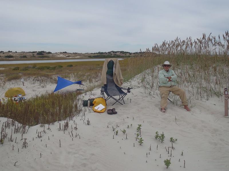
Site 8 is spacious, and has a tall dune in front of camp, which makes a good windblock from ocean breezes, but of course also takes a while to get sunny first thing in the chill off-season morning.
 PA160416 by Mike McCrea, on Flickr
Nice view from atop that beachfront dune though
 PA170435 by Mike McCrea, on Flickr
BTW, all of those site observations are prior to last year’s hurricane. It’s a shifting barrier island, so. . . . .
Some of the sites further away from the landing are likewise very exposed and, although none are a long walk, hiking over loose sand encumbered with gear and potable water is its own challenge.
 PA160433 by Mike McCrea, on Flickr
 PA150371 by Mike McCrea, on Flickr
If you are lucky you might encounter King Canute’s empty throne on the beach, His Highness having been swept out to sea trying to turn back the tide
 PA170443 by Mike McCrea, on Flickr
(Seriously, another of those oft-windy places where a wind block extension on the chair is welcome )
Uh, the facilities, the bathhouse thing down-island near the ferry landing, is a long sandy-hiking ways away. I have never set foot it in it, or even gotten close. I really don’t want to see that kind of syphilization structure, and it too far to hike just to take a morning dump. I bring the wag-bag bucket toilet system instead. And the Fire In A Can of course (no fires permitted at Hammocks Beach, but the FIAC has always been Ranger pre-approved for use.
The beach is pristine. Still, it looks the same hiking up as hiking back; not as interesting as day paddling, or foot wandering behind the dunes or along the marsh side.
PA150371 by Mike McCrea, on Flickr
Rough out a trip plan? Sure. But I have had good luck getting the site I wanted on short notice, at least in October/November or February/March. By short notice I mean a couple or threefour days out. I’m looking for a combination of three things.
Favorable tides for a morning paddle in, and an afternoon paddle out. That one at least is researchable for dates that work well in advance. Use Bogue Inlet, plus an hour for tides filling in or draining out at the mainland HQ launch back in the marsh.
https://www.saltwatertides.com/dynam...linasites.html
Decently warm or dry weather. It can be 50+f or 30f on those shoulder seasons, or even mid-winter. Constant wind and cold is kinda brutal there.
Manageable winds, both speed and direction. Most of the route is marsh protected, but even at a measly 2.5 mile paddle I don’t want to bust my arse getting in or out. Or camp amidst howling winds and blowing sand.
Pick any two above; all three if you get lucky.
It would be a helluva place to paddle a big fast Mad River Northwoods loaded with gear and potable water ;-)
(Check to see if dogs are permitted)
Oceanside, it’s not just for kayaks anymore.
The only web page I found that should have had a water trail map was a dead link. Do you know of one that can be downloaded? And by "shollow water" do you mean paddle digging stand up and pole shallow? Or just take advantage of the tidal surge to help you along shallow?
Try this link. Go to the right margin and click on Campground Map, and Paddle Trails Map
https://www.ncparks.gov/hammocks-beach-state-park/home
By shallow at low tide I mean that the inlet to the beachfront sites may require wading the boats
IMG010 by Mike McCrea, on FlickrThat drag was up the inlet en route to the beachfront sites. Sites 12, 13 and 14 are before, or at least a short drag alongside the inlet shallows on the way in. The large open basin past the inlet narrows towards the beachfront sites is usually deep enough to paddle across.
Still, I’d time the tides to paddle out (and back in) for near high tide, so there is paddle blade depth of water in the marsh. Obviously slack to falling tide on the way out helps, and vice versa on the way back. Not that critical for tidal depth along the marked trail through the marsh, but more water, moving in the right direction, is better. Tides done right much the trail is an assisted ride.
which campsite is that back in the trees? Looking at the reservation pages of the three paddle in only sites (12-14) 14 has no pictures, 13 shows wide open spaces and 12 shows trees. Do you know if there are trees back of all three sites?
Whadda ya want, an extensive, photo heavy travelogue? Happy to oblige, I think Hammocks Beach is another NC State Park off-season gem, on par with Merchants Millpond, but very different from that scenic cypress swamp paddle-in camper
Site 14 is back in the trees, and is my least favorite site. It is sometimes too shady and damp feeling, but it has room for multiple tents, tarps and larger parties.
P3172667 by Mike McCrea, on FlickrSite 13 is, uh, interesting in a unique way. A split level site; a dozen steps away from the site landing is a sandy area with room for a tent.
P3172664 by Mike McCrea, on FlickrAtop the towering dune immediately behind the site is another part, a second flat sandy area with room for a tent or two and a tarp. There is (dense) forest in back of the top plateau, but distant. Cool place to wander the high dune forest edge though.
The view from site 13’s top plateau area is amazing, far out into the Atlantic. But there isn’t much shade, other than the tall, steep dune backdrop at the bottom area in the evening, and zero escape from the wind.
P3172665 by Mike McCrea, on FlickrSite 12 is my favorite. And open sandy area near the inlet with room for a tent and tarp, and an enclosed shady grotto enveloped by the limbs of a couple live oak. At low tide use the easier landing for site 13; it is not far away and there is a short trail between the two. If I wanted two inlet sites, with companions on a separate permit, I’d take 12 and 13.
P3152656 by Mike McCrea, on FlickrPA281464 by Mike McCrea, on FlickrThe beachfront sites, if that’s your thing, are trickier. The couple sites closest to the paddle-in landing, sites 5, 6 and 7, are kind of exposed to wind off the ocean.
IMG011 by Mike McCrea, on FlickrIMG012 by Mike McCrea, on FlickrAnd some of the dune sites are pretty small tent/tarp wise. That is site 5.
PA160408 by Mike McCrea, on FlickrSite 8 is spacious, and has a tall dune in front of camp, which makes a good windblock from ocean breezes, but of course also takes a while to get sunny first thing in the chill off-season morning.
PA160416 by Mike McCrea, on FlickrNice view from atop that beachfront dune though
PA170435 by Mike McCrea, on FlickrBTW, all of those site observations are prior to last year’s hurricane. It’s a shifting barrier island, so. . . . .
Some of the sites further away from the landing are likewise very exposed and, although none are a long walk, hiking over loose sand encumbered with gear and potable water is its own challenge.
PA160433 by Mike McCrea, on FlickrPA150371 by Mike McCrea, on FlickrIf you are lucky you might encounter King Canute’s empty throne on the beach, His Highness having been swept out to sea trying to turn back the tide
PA170443 by Mike McCrea, on Flickr(Seriously, another of those oft-windy places where a wind block extension on the chair is welcome )
Uh, the facilities, the bathhouse thing down-island near the ferry landing, is a long sandy-hiking ways away. I have never set foot it in it, or even gotten close. I really don’t want to see that kind of syphilization structure, and it too far to hike just to take a morning dump. I bring the wag-bag bucket toilet system instead. And the Fire In A Can of course (no fires permitted at Hammocks Beach, but the FIAC has always been Ranger pre-approved for use.
The beach is pristine. Still, it looks the same hiking up as hiking back; not as interesting as day paddling, or foot wandering behind the dunes or along the marsh side.
PA150371 by Mike McCrea, on FlickrAnd since they take reservations 11 months out is it too early to begin to rough out a trip plan?
Rough out a trip plan? Sure. But I have had good luck getting the site I wanted on short notice, at least in October/November or February/March. By short notice I mean a couple or threefour days out. I’m looking for a combination of three things.
Favorable tides for a morning paddle in, and an afternoon paddle out. That one at least is researchable for dates that work well in advance. Use Bogue Inlet, plus an hour for tides filling in or draining out at the mainland HQ launch back in the marsh.
https://www.saltwatertides.com/dynam...linasites.html
Decently warm or dry weather. It can be 50+f or 30f on those shoulder seasons, or even mid-winter. Constant wind and cold is kinda brutal there.
Manageable winds, both speed and direction. Most of the route is marsh protected, but even at a measly 2.5 mile paddle I don’t want to bust my arse getting in or out. Or camp amidst howling winds and blowing sand.
Pick any two above; all three if you get lucky.
It would be a helluva place to paddle a big fast Mad River Northwoods loaded with gear and potable water ;-)
(Check to see if dogs are permitted)
Last edited:

 ) is to bring them by boat. If Rosie will ever calm down enough to ever be predictable in a canoe. Maybe filling her full of benadryl would be the ticket. And tying her under the spray deck......with a hood over her eyes....and nose plugs.....maybe ear plugs, too.
