This river has been discussed a bit here lately, so I decided to post a brief trip report. This is a trip I’ve done a few times previously, but it’s a good one! This trip was rather unique in a number of ways.
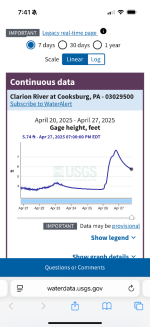
My wife, father in law, good friend and I dropped a shuttle vehicle at mill creek canoe access near clarion, Pennsylvania and then made the hour long drive to our put in 40 miles upstream at Irwin run. We made it there by 7:00 PM. I’d been watching the cooksburg river gauge hoping the river levels would rise. The gauge was at 3.66 and dropping Friday evening. It looked low when we arrived. We stayed at the walk in campsite at Irwin run, but left the canoes on the trailer. If levels didn’t rise, we’d be driving downstream to put in and shorten the trip. We were enjoying some wine in camp after dinner when the skies just opened about 10:00. Nothing violent, but it was raining hard as we went to bed. It rained hard for hours as the very slow moving system just sat over the area dumping moisture.
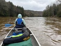
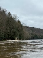
When we arose Saturday morning, the river was brown and swollen. The stick I had placed in the bank to mark the river level was not visible under the water. The river was up at least 2’ and continued to rise as we ate breakfast and packed. Temps were still in the low 60’s, rain had stopped.
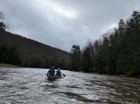
We hit the river by 9:30 and just flew downstream. This was perhaps more than I’d hoped for, but it was fun! I checked my Gaia app periodically and we were averaging 5 mph with very few forward strokes.
The rapids did require some of our paddling skills as some were Class II at this level. We had standing wave trains of 3-4’ and took plenty of water in the boats. We stopped at clear creek state park to eat some lunch and dump water out of the boats.
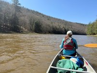
Meanwhile, temps had fallen to upper 40’s and it got very windy. The wind was mostly a headwind. We had to paddle to keep the boats straight, but the swift current kept us moving in spite of the wind.
We encountered hopeful paddlers at the park who had canceled their trip because the state parks had closed their launches (the launch we used is federal). The state parks deemed the river to be at flood stage. It had approached its banks in some places, flooding some trees, but the river did not feel unsafe to us. We continued on as the river continued to rise with the surrounding mountains draining their moisture. The hopeful paddlers reported that the gauge now read 7 feet at cooksburg! When I was able to look at the gauge report online after exiting the river today, I saw that it crested at 7.5 at about 9 PM Saturday evening.
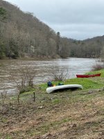
We stayed Saturday night at Thompson eddy canoe sites. It was lovely.
Finished in the best part of the river today. It was very fast and at least two of the rapids were still at class II. My gauge stick stuck in the bank at our campsite showed that the water had dropped about a foot by Sunday morning.
My wife, father in law, good friend and I dropped a shuttle vehicle at mill creek canoe access near clarion, Pennsylvania and then made the hour long drive to our put in 40 miles upstream at Irwin run. We made it there by 7:00 PM. I’d been watching the cooksburg river gauge hoping the river levels would rise. The gauge was at 3.66 and dropping Friday evening. It looked low when we arrived. We stayed at the walk in campsite at Irwin run, but left the canoes on the trailer. If levels didn’t rise, we’d be driving downstream to put in and shorten the trip. We were enjoying some wine in camp after dinner when the skies just opened about 10:00. Nothing violent, but it was raining hard as we went to bed. It rained hard for hours as the very slow moving system just sat over the area dumping moisture.
When we arose Saturday morning, the river was brown and swollen. The stick I had placed in the bank to mark the river level was not visible under the water. The river was up at least 2’ and continued to rise as we ate breakfast and packed. Temps were still in the low 60’s, rain had stopped.
We hit the river by 9:30 and just flew downstream. This was perhaps more than I’d hoped for, but it was fun! I checked my Gaia app periodically and we were averaging 5 mph with very few forward strokes.
The rapids did require some of our paddling skills as some were Class II at this level. We had standing wave trains of 3-4’ and took plenty of water in the boats. We stopped at clear creek state park to eat some lunch and dump water out of the boats.
Meanwhile, temps had fallen to upper 40’s and it got very windy. The wind was mostly a headwind. We had to paddle to keep the boats straight, but the swift current kept us moving in spite of the wind.
We encountered hopeful paddlers at the park who had canceled their trip because the state parks had closed their launches (the launch we used is federal). The state parks deemed the river to be at flood stage. It had approached its banks in some places, flooding some trees, but the river did not feel unsafe to us. We continued on as the river continued to rise with the surrounding mountains draining their moisture. The hopeful paddlers reported that the gauge now read 7 feet at cooksburg! When I was able to look at the gauge report online after exiting the river today, I saw that it crested at 7.5 at about 9 PM Saturday evening.
We stayed Saturday night at Thompson eddy canoe sites. It was lovely.
Finished in the best part of the river today. It was very fast and at least two of the rapids were still at class II. My gauge stick stuck in the bank at our campsite showed that the water had dropped about a foot by Sunday morning.
Attachments
Last edited: