- Joined
- Mar 27, 2022
- Messages
- 29
- Reaction score
- 34
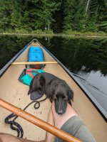
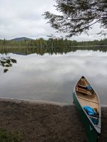
For my first overnight solo canoe trip (well, except for the company of my dog, Monty), I did a slightly modified version of the justly popular Floodwood Pond Loop.
I left from Binghamton, NY, around 2:30am on Thursday, September 7--a bit of an alpine start, but I had limited time and wanted to maximize daylight. Following @dtvburns's advice, I dropped my canoe (a new-to-me Nova Craft Fox 14') and gear at the Floodwood Outpost and then drove about a mile down the road to the Long Pond access point. I parked my truck there and walked back to the Floodwood Outpost with Monty. This allows one both to skip the last, longest, and swampiest portage and to paddle further on Long Pond at the end of the loop--a win-win. Once back to the Floodwood Outpost, I signed-in at the trail register and set off across Floodwood Pond around 8:30am.
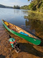
My plan for the first day was to paddle to Follensby Clear Pond and find a campsite there. There are no portages on the first day, so it's easy to get into a groove and cruise. Monty and I did just that--a good idea, as it turned out, since some brief but vigorous storms passed through shortly after we set up camp. In any case, the loop, if done counter-clockwise, begins with a southeast traverse of Floodwood Pond. From there, one picks up a quaint, south-flowing waterway called Fish Creek. The woods along the creek were absolutely teaming with birds when we paddled through, which Monty loved. Fish Creek passes along the eastern side of Little Square Pond and then contniues for a ways. It eventually becomes Fish Creek Ponds, which is home to Fish Creek Pond Campground. The campground caters more to the pontoon boat/RV crowd, but it was quiet enough when we passed through. I imagine one could get a hot shower here if they wanted.
The Fish Creek Ponds make up the southern-most point of the loop. After paddling across the first Fish Creek Pond, one turns northeast, passes under Route 30, and enters the second Fish Creek Pond. I was happy to make this turn, since it meant I was almost to quieter and more remote waters.
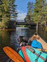
At its northeast corner, the second of the Fish Creek Ponds empties into Spider Creek, which connects the Fish Creek Ponds to Follensby Clear Pond. Spider Creek is another quaint waterway. It passes under Route 30 again, except this time, the passage marks a transition to quieter waters.
Monty and I reached Follensby Clear Pond around 11:30am--earlier than expected but just in time, as the wind was picking up and dark clouds were moving in. I wanted to find an island campsite that was otherwise unoccupied so I could let Monty off leash for a while. The first few island sites on Follensby Clear Pond were all occupied. There was one small, unoccupied island, but it had a 'Camping Prohibited' sign, so we moved on.
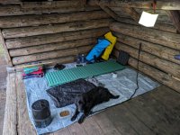
Shortly after Follensby Clear Pond narrows, we found an unoccupied island site--and with a lean-to, at that! Especially with rain coming, we decided to camp here for the first night. An hour or so after I set up camp, it started raining pretty hard and with a healthy dose of wind, thunder, and lightning. I had to hang a tarp on the front of the lean-to to prevent the rain from blowing in. Monty and I hunkered down. I read a few pages and, as the early start caught up with me, I fell asleep.
When I woke up, the rain had stopped. I decided to go fishing since we still had a couple hours until dinnertime. I caught a handful of small perch, a couple pumpkinseed fish, and a smallmouth bass. No keepers, though. This was my first time fishing with Monty in the canoe. He tends to obsess over small animals, so I was interested--and a bit nervous--to see how he would react to the fish. Surprisingly, he was mostly uninterested.
After dinner, I read some more and then went to bed pretty early. It was one of those days that felt, in hindsight, like it was way too long to be a single day.
The next morning, we paddled nothward to the end of Follensby Clear Pond and to the first portage. There are two canoe carries at the northern end of the pond. The one on the left, which I was supposed to take, goes to Polliwog Pond. The one on the right, which I actually took--completely absent-mindedly--goes to Green Pond. Once on Green Pond, I realized my mistake fairly quickly, via one of those 'this doesn't feel quite right, let me check the map' feelings. The fact that the water was a beautiful green color might have helped me out at the subconscious level, too. Oh well--pretty minor, as far as mistakes go, and the water really is impressively green. So as to avoid an extra portage, I decided to paddle across Green Pond, walk up to Floodwood Road, and then pick up the carry to Hoel Pond from there (the carry from Polliwog Pond to Hoel Pond crosses Floodwood Road anyway). However, this didn't work out, since there's no way to go from Green Pond to Floodwood Road without cutting through someone's yard: Green Pond is completely surrounded by private cottages.
So we backtracked. Back to Follensby Clear Pond. Then a quick paddle to the correct carry to Polliwog Pond. Then a brief, northward paddle across Polliwog Pond, and a longer carry to Hoel Pond. Since I parked at Long Pond, this was the longest carry. I would put it on the long side of 1/2 mile--not terrible, but long enough to make two trips annoying. At least Monty got a nice walk.
I was feeling a little flustered from my mistake and from my failed attempt to redeem it, so I paddled fairly quickly across Hoel Pond. At its northwestern end, Hoel Pond connects to Turtle Pond via a small culvert. The 'proper' way to get to Turtle Pond it to carry over the culvert, but we went through it. I suspect a lot of people do. It's a fun little tunnel. I walked behind the canoe but left Monty in it. He looked concerned but never tried to jump ship. Good boy. For anyone who likes to baby their boats: there's a ~8" drop from the culvert into Turtle Pond that makes it tricky to exit the culvert, which is made of concrete, without scratching the bottom of one's canoe--especially if one's canoe is loaded with, among other things, a medium-sized dog. We managed to (mostly) avoid this, but it was a bit precarious.
Turtle Pond lies just inside the St. Regis Canoe Area and is where the quiet really begins to set in. This was a welcome transition. I think I'd like for my next trip to be all within the St. Regis Area. In fact, I never quite appreciated how the town of Saranac Lake is prefectly located between some of the best paddling and best hiking and climbing on the East Coast. I fantisized, during this stretch, about moving there.
In any case, Turtle Pond connects, at its western edge, to Slang Pond via a shallow, narrow channel. People who want to avoid scratches might want to walk their canoes through here, as well. Monty and I found a nice campsite on Slang Pond and went through the normal evening routine of setting up camp, eating dinner, cleaning up, and then reading a few pages before bed.
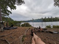
Not a whole lot of paddling remained for Saturday: a short paddle across Slang Pond, a carry to Long Pond, and then a (longer) paddle across Long Pond. Since the parking area for Long Pond is at its western tip, one gets to paddle basically all of it if they park there instead of at the Floodwood Outpost. I think the last day was my favorite from a pure paddling perspective. It doesn't look much different from the rest of the loop, but the water was perfectly glassy, there was no noise except my paddle in the water and the occasional loon call, and I was feeling superbly at home in my canoe: everything was just plain smooth.
After a ~1/4 mile carry to my truck and a quick stop at the Floodwood Outpost to sign out at the trail register (and, of course, buy an ice cream sandwhich), our short trip was a wrap. I would highly recommend this trip--especially, but not only, to relative beginners like me. It could easily be done in two days, but there's enough worth lingering over to merit a third.
I left from Binghamton, NY, around 2:30am on Thursday, September 7--a bit of an alpine start, but I had limited time and wanted to maximize daylight. Following @dtvburns's advice, I dropped my canoe (a new-to-me Nova Craft Fox 14') and gear at the Floodwood Outpost and then drove about a mile down the road to the Long Pond access point. I parked my truck there and walked back to the Floodwood Outpost with Monty. This allows one both to skip the last, longest, and swampiest portage and to paddle further on Long Pond at the end of the loop--a win-win. Once back to the Floodwood Outpost, I signed-in at the trail register and set off across Floodwood Pond around 8:30am.

My plan for the first day was to paddle to Follensby Clear Pond and find a campsite there. There are no portages on the first day, so it's easy to get into a groove and cruise. Monty and I did just that--a good idea, as it turned out, since some brief but vigorous storms passed through shortly after we set up camp. In any case, the loop, if done counter-clockwise, begins with a southeast traverse of Floodwood Pond. From there, one picks up a quaint, south-flowing waterway called Fish Creek. The woods along the creek were absolutely teaming with birds when we paddled through, which Monty loved. Fish Creek passes along the eastern side of Little Square Pond and then contniues for a ways. It eventually becomes Fish Creek Ponds, which is home to Fish Creek Pond Campground. The campground caters more to the pontoon boat/RV crowd, but it was quiet enough when we passed through. I imagine one could get a hot shower here if they wanted.
The Fish Creek Ponds make up the southern-most point of the loop. After paddling across the first Fish Creek Pond, one turns northeast, passes under Route 30, and enters the second Fish Creek Pond. I was happy to make this turn, since it meant I was almost to quieter and more remote waters.

At its northeast corner, the second of the Fish Creek Ponds empties into Spider Creek, which connects the Fish Creek Ponds to Follensby Clear Pond. Spider Creek is another quaint waterway. It passes under Route 30 again, except this time, the passage marks a transition to quieter waters.
Monty and I reached Follensby Clear Pond around 11:30am--earlier than expected but just in time, as the wind was picking up and dark clouds were moving in. I wanted to find an island campsite that was otherwise unoccupied so I could let Monty off leash for a while. The first few island sites on Follensby Clear Pond were all occupied. There was one small, unoccupied island, but it had a 'Camping Prohibited' sign, so we moved on.
Shortly after Follensby Clear Pond narrows, we found an unoccupied island site--and with a lean-to, at that! Especially with rain coming, we decided to camp here for the first night. An hour or so after I set up camp, it started raining pretty hard and with a healthy dose of wind, thunder, and lightning. I had to hang a tarp on the front of the lean-to to prevent the rain from blowing in. Monty and I hunkered down. I read a few pages and, as the early start caught up with me, I fell asleep.

When I woke up, the rain had stopped. I decided to go fishing since we still had a couple hours until dinnertime. I caught a handful of small perch, a couple pumpkinseed fish, and a smallmouth bass. No keepers, though. This was my first time fishing with Monty in the canoe. He tends to obsess over small animals, so I was interested--and a bit nervous--to see how he would react to the fish. Surprisingly, he was mostly uninterested.
After dinner, I read some more and then went to bed pretty early. It was one of those days that felt, in hindsight, like it was way too long to be a single day.
The next morning, we paddled nothward to the end of Follensby Clear Pond and to the first portage. There are two canoe carries at the northern end of the pond. The one on the left, which I was supposed to take, goes to Polliwog Pond. The one on the right, which I actually took--completely absent-mindedly--goes to Green Pond. Once on Green Pond, I realized my mistake fairly quickly, via one of those 'this doesn't feel quite right, let me check the map' feelings. The fact that the water was a beautiful green color might have helped me out at the subconscious level, too. Oh well--pretty minor, as far as mistakes go, and the water really is impressively green. So as to avoid an extra portage, I decided to paddle across Green Pond, walk up to Floodwood Road, and then pick up the carry to Hoel Pond from there (the carry from Polliwog Pond to Hoel Pond crosses Floodwood Road anyway). However, this didn't work out, since there's no way to go from Green Pond to Floodwood Road without cutting through someone's yard: Green Pond is completely surrounded by private cottages.
So we backtracked. Back to Follensby Clear Pond. Then a quick paddle to the correct carry to Polliwog Pond. Then a brief, northward paddle across Polliwog Pond, and a longer carry to Hoel Pond. Since I parked at Long Pond, this was the longest carry. I would put it on the long side of 1/2 mile--not terrible, but long enough to make two trips annoying. At least Monty got a nice walk.
I was feeling a little flustered from my mistake and from my failed attempt to redeem it, so I paddled fairly quickly across Hoel Pond. At its northwestern end, Hoel Pond connects to Turtle Pond via a small culvert. The 'proper' way to get to Turtle Pond it to carry over the culvert, but we went through it. I suspect a lot of people do. It's a fun little tunnel. I walked behind the canoe but left Monty in it. He looked concerned but never tried to jump ship. Good boy. For anyone who likes to baby their boats: there's a ~8" drop from the culvert into Turtle Pond that makes it tricky to exit the culvert, which is made of concrete, without scratching the bottom of one's canoe--especially if one's canoe is loaded with, among other things, a medium-sized dog. We managed to (mostly) avoid this, but it was a bit precarious.
Turtle Pond lies just inside the St. Regis Canoe Area and is where the quiet really begins to set in. This was a welcome transition. I think I'd like for my next trip to be all within the St. Regis Area. In fact, I never quite appreciated how the town of Saranac Lake is prefectly located between some of the best paddling and best hiking and climbing on the East Coast. I fantisized, during this stretch, about moving there.
In any case, Turtle Pond connects, at its western edge, to Slang Pond via a shallow, narrow channel. People who want to avoid scratches might want to walk their canoes through here, as well. Monty and I found a nice campsite on Slang Pond and went through the normal evening routine of setting up camp, eating dinner, cleaning up, and then reading a few pages before bed.

Not a whole lot of paddling remained for Saturday: a short paddle across Slang Pond, a carry to Long Pond, and then a (longer) paddle across Long Pond. Since the parking area for Long Pond is at its western tip, one gets to paddle basically all of it if they park there instead of at the Floodwood Outpost. I think the last day was my favorite from a pure paddling perspective. It doesn't look much different from the rest of the loop, but the water was perfectly glassy, there was no noise except my paddle in the water and the occasional loon call, and I was feeling superbly at home in my canoe: everything was just plain smooth.


After a ~1/4 mile carry to my truck and a quick stop at the Floodwood Outpost to sign out at the trail register (and, of course, buy an ice cream sandwhich), our short trip was a wrap. I would highly recommend this trip--especially, but not only, to relative beginners like me. It could easily be done in two days, but there's enough worth lingering over to merit a third.
Last edited:
