Cree River Section 5
Sometimes the best maps will not guide you.
You can't see what's round the bend.
(Bruce Cockburn, Pacing the Cage)
Here, the trip report takes a turn. For six weeks at least I have been unable to find my maps and the cut out section from the Archer book. Both these items contain notes to help me review where I camped and notes about the river and its shores. Rather than continue to delay this report, I will push on in much the way I did the river, never knowing for sure where I am.
I've never seen a place like the forested shores along the Cree River. The woods are open, carpeted with reindeer moss and various other lichens, and the trees are narrow unless they are fortunate enough to be on the edge and stretching into the extra light. The middle story is absent. It has a subtle beauty and I have to slow my heart and and brain to appreciate it. Full of greens of various shades.
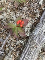
This time of year, the most color comes from the bright red berries of Canada Mayflower. Occasional rocks are coated with lichens. There are none of the huge rocks or exposed bedrock as we are used to on the Canadian Shield.
Canadian Mayflower. In the spring, it boasts beautiful cream flowers.
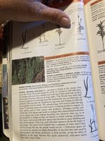
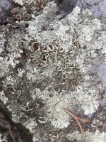
I know the name of this lichen, but can’t remember it at this time. The interesting aspect of this lichen is the cup shaped structures which tell us the symbiotic fungus is an Ascomycete, the “cup fungi.” The brown inside the cups are the spores.
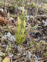
Ground pines are small replicas of the trees for which they are named. They gather in some of the damper areas of the trail. I found a small group of a kind I had never seen before. I took several pictures to increase the chances I would be able to identify them after the trip.
The moose have laid deep and easy game trails through the reindeer moss. This bench stretches for maybe a half mile before descending once again into wet meadows.
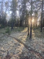
It is easy to see there is no midstory in these forests. Just tall trees and lowly lichens. The moose and others carve the easiest trails parallel to the shoreline.
AUGUEST 28, 2024 -
maybe
Woke in bliss. Comfortable is too weak a word for it. I don't even want to move. Dozed on. Woke fully at 7 am. Held friends and family in the Light and expressed gratitude for feeling so good.
Yesterday the paddling flew by so quickly. It took forever to load the canoe. I lost my knee pads, so I cut up the Ridge Rest to pad my knees. A slice out of the center to accommodate the central D-ring.
The first challenge was to pull the canoe over the rocks to the current and into a small eddy behind a rock pile. The water is deeper than I can get into the boat. I positioned the boat near a slightly larger rock so I can stand on it and manage to get in spite of the current. (Another prayer of gratitude.) There is supposed to be an RI, then a couple of K of RII and then into Hawk Rapids which is mostly RI but has two RII ledges. This is all per Archer. But there are no signs on the river telling you when you are moving, rather quickly, from one “set” to another. It looks so neat in the Archer book maps and it is a total mystery on the river.
The water just goes and goes and goes and I, in Dancer, ride with it. I'm back paddling in the large waves, then brace and paddle on. Taking the curves, which cannot be taken on the inside due to rocks and strainers. Ran into some huge waves except they weren't waves exactly. I had never see anything like them before. It is like a big swell in Gulf; you go up, up, up and then the water drops out from under you. I am back paddling as hard as I can and Dancer takes them like she was born to it. I end up sideways to the current, maybe a bit backwards, it is all happening so fast I can't keep track.
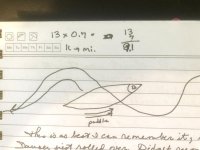
This sketch is the best I can remember it. (I sketched it out that night when my memory was fresh.) But it could be wrong. It did not seem like a ledge - too smooth. Plus it was on RL and there weren't supposed to be any ledges on RL.
Now it is mostly shallow rocks. Got stuck and had to get out twice. This is tricky with the fast current and rocks about the size of grapefruits, all round and slippery. Carefully saying to myself: "Get out on the upstream side. Do not put yourself between the canoe and the rock. Don't get downstream of the canoe." I'm doing my best to wiggle the canoe in between the shallow or larger rocks. Sudden stop. Crunch. The sound turned my stomach sick, but I could not find anything wrong with the boat and it still floated (when there was enough water) so we soldiered on.
Some hits I managed to lean hard downstream toward the rock and the current set me free. I was proud of myself to remember that bit of white water wisdom.
Came across a huge tower of rock in the center of the river. Could it be Hawk Island? If so, I was close to the end. But it all seemed to go so fast, too fast to already be at Hawk Island.
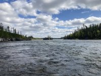
Hawk Island. It is much taller than appears in the photo. There are rock cliffs on either side of the river and they are about two stories high. The island is also that high. Clearly at some point in time, the river blasted through the rock ridge.
If it weren't twisty enough, the river now becomes a network of criss-crossing threads of current through the rocks. How to decide which one to pick? The river is wide and sometimes you (or I anyway) can't see to the end. How to pick?
Crash. Again. I get out on the upstream side and before I can grab and end, the canoe slips broadside and hits another rock, this time on the other end of the canoe. I now have that which no one wants to confront on a canoe trip: A canoe stuck broadside to the current. You could said it was lucky the water was shallow and the current not as steep as some could be. And you would be right. But nevertheless, it was a bad place for me to be. How was I going to get the canoe floating again. The current was too strong for me to move either end of the boat.
I had just passed a bigger bunch of dry rocks and I had thought to stop there. Too late, I was now downstream of those rocks.
My journal states I "started to walk the canoe to RR." But there is no mention of how I got the canoe off the rocks. But apparently I did.
BUT the rocks I was stranded on were not actually ON RR. There were a couple of reefs of rock to drag over, but most concerning was a narrow but fast moving current, like a river.
I fell. This happened frequently so is not of great note, except for that streaming current. The water became deeper, which was predictable based on the fast dark current. Once I no longer had contact with the ground, the current takes us all away. (Keep your feet up, Erica!) I can see in an instant how this could turn out very badly.
I can't stand, so I crawl on the slippery rocks in the current. Holding my staff in my right hand and the canoe with my left hand. Stumbling badly. Another fall. The water lifts the staff out of my hand, even though the strap is around my wrist. It was gentle and like magic. It just lifted my staff off my hand and took it away. In a microsecond. I never did find it. (This reinforced my image of what would happen should the canoe be wrested out of my hand.)
I push, push, push across the current for the shore as we are being pulled downstream. I grab at some grasses growing between rocks in the river. It's not much, and they pull out a couple of times, but that little extra allows me to pull myself up to standing. Canoe is still in my left hand.
There is no eddy. I know some of you reading this are going to this that is nonsense. But I promise you there was no eddy. The current pushes through everything in its way. It is a long slow pull up to the rocks on the shoreline. I look longingly at the larger space just upstream, but getting there would require getting back into the current. I choose to stay.
My notes now say: "Remember the time I was getting back in the boat and my left heel got stuck in the bow cover? Remember the time you decided to run a rapid sitting?" The answer is, No, I don't remember either situation and I have no idea what I was referring to. I assume it was two other times I got myself into a comical set of circumstances.
I am sitting on a dry pile of rocks at the edge of the river. The sun is warm on my face. My clothes are drying out And it comes over me: I am finally on a canoe trip.
Research later showed me to be just downstream of Hawk Island. Tall bluffs of sandstone perched on either side of the river.
I am too tired to fight the river this afternoon. In fact, I am too tired to do much besides sit in the sun. I
will find somewhere here to pitch the tent. Later in the afternoon I will discover I can't find my solar charger and the bow of the boat is (cringe) beaten up. But right now, in the sun, I am blissfully ignorant of these future challenges.

